Relief shown pictorially and by hachures. and Shows the Canadian-United States border from Lake Ontario along the St. Lawrence River to 45₋p0₋s N. latitude, east to the Connecticut River, and northeast along the "Height of the land." Coverage of areas away fr
Subject (Geographic):
Canada--Boundaries--United States--Maps--Early works to 1800, New York (State)--Maps--Early works to 1800, Québec (Province)--Maps--Early works to 1800, and United States--History--Revolution, 1775-1783--British forces
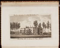
Opposite page 1. Description of the villa of Horace Walpole ...
Image Count:
1
Resource Type:
still image
Abstract:
A view of the east front of Strawberry Hill, looking from the Thames. A gentleman and lady converse on the left. On the right a workman tends the lawn with a scythe
An album of engraved tickets, invitations, bookplates, and other designs, some in mulitple impressions and states, mostly black and white, with some in sepia ink and colored inks. Mostly by Bartolozzi and his pupils. Other artists and printmakers include: I.C.B., G.B. Cipriani, Edward Burney, E. Edwards, Smirk, L. Legoux, H. Bunbury, W. Hamilton, Robert Cooper, Topham, Angelica Kaufman, Anthony Pasquin [pseudo. of John Williams], M. Vdr. Gucht, A. Van Assen. Most engravings are untitled and undated; the dated tickets fall between 1776-1796 A few plates with printers and publishers named: W. Hinton, G. Graglia, Mr. Sandby, J. Sewell. Occasional contemporary annotations, including the stamped initials "M. R."
Errata: 8 lines on p. xv., Imperfect: p. 17-18, 657-658, and all after p. 686 wanting. Date of publication and part of publisher's names torn from t.-p.; plate 3 mutilated., Includes index., and Page xv misnumbered vx.