Skip to search
Skip to main content
Skip to first result
Search
You Searched For
Format
cartographic
Genre
Engravings
Genre
Maps in books
New Search
Search Results
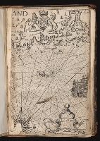
Published / Created:
[Ca. 1612]
Call Number:
Pequot G325
Collection Title:
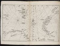
Descriptio ac delineatio geographica detectionis freti, sive, transitus ad occasum supra terras
Image Count:
1
Description:
Bound in after p. [40]. and Scale [ca. 1:10,000,000].
Subject (Geographic):
Barents Sea --Maps --Early works to 1800 and Norwegian Sea --Maps --Early works to 1800
Collection Created:
Amsterodami Ex officina Hesse lij Gerardi. Anno 1613
Found in:
Beinecke Rare Book and Manuscript Library > [Barents Sea and Norwegian Sea]
Published / Created:
[Ca. 1612]
Call Number:
Taylor 258
Collection Title:
Descriptio ac delineatio geographica detectionis freti, sive, transitus ad occasum supra terras
Image Count:
1
Description:
Bound in after p. [40]., Map has water stain on recto in upper right corner., Printed on recto in lower right corner: F., and Scale [ca. 1:10,000,000].
Subject (Geographic):
Barents Sea --Maps --Early works to 1800. and Norwegian Sea --Maps --Early works to 1800
Collection Created:
Amsterodami Ex officina Hesse lij Gerardi. Anno 1613
Found in:
Beinecke Rare Book and Manuscript Library > [Barents Sea and Norwegian Sea]
Published / Created:
[1618]
Call Number:
Taylor 275
Collection Title:
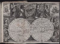
Journal ou relation exacte du voyage de Guill Schouten
Image Count:
1
Description:
Bound in after p. [8]., Busts of various explorers depicted around edges of map., Four small areas with stains on verso., Scale not given., and Western hemisphere of North and South America hand colored.
Subject (Topic):
Oceania --Discovery and exploration --Early works to 1800, Voyages around the world --Early works to 1800, and World maps --Early works to 1800
Collection Created:
A Paris : chez M. Gobert, au Palais en la gallerie des prisonniers, et les cartes, chez M. Tauernier, graueur du roy, demeurant au pont Marchand, 1618
Found in:
Beinecke Rare Book and Manuscript Library > [Double hemisphere map of the world showing track of Schouten’s voyage in 1615-1617]
Published / Created:
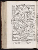
[1554]
Call Number:
Taylor 115 1
Collection Title:
Primo volume, & seconda editione delle nauigationi et viaggi
Container / Volume:
v. 1
Image Count:
1
Abstract:
Map of Africa. South oriented projection.
Description:
Bound in. 284 recto.
Subject (Geographic):
Africa--Maps--Early works to 1800. and Nile River--Maps--Early works to 1800
Collection Created:
In Venetia : nella stamperia de Giunti,
Found in:
Beinecke Rare Book and Manuscript Library > [Map of Africa]
Call Number:
1974 +231
Collection Title:
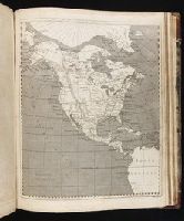
A new and elegant general atlas, comprising all the new discoveries, to the present time
Image Count:
1
Description:
Map 36 from table of contents.
Subject (Geographic):
North America--Maps
Collection Created:
Philadelphia, J. Conrad & co., Baltimore, M. & J. Conrad & co. [etc., etc.] 1804
Found in:
Beinecke Rare Book and Manuscript Library > [Map of North America]
Published / Created:
1618?
Call Number:
Taylor 278
Collection Title:
Jovrnal ou Description dv merveillevx voyage de Gvillavme Schovten, hollandois natif de Hoorn
Image Count:
1
Description:
Bound in facing p. 72., Imperfect: Map wormed, with loss of text; repair made on back of map., and Scale not given.
Subject (Geographic):
New Guinea --Maps --Early works to 1800
Subject (Name):
Schouten, Willem Corneliszoon, d. 1625
Collection Created:
A Amstredam : Chez Harman Ianson, marchand libraire, demeurant en la VVarmoes-straet, a le Sereine, 1619
Found in:
Beinecke Rare Book and Manuscript Library > [Map of Nova Guinea]
Creator:
Published / Created:
Undated
Call Number:
Taylor 216A
Collection Title:
Iohn Huighen van Linschoten, his Discours of Voyages into ye Easte & West Indies : deuided into
Image Count:
1
Description:
Bound in following title page of second book. and Map has small tear at bottom fold in center.
Subject (Geographic):
Africa --Maps --Early works to 1800, Cape of Good Hope --Maps, Congo (Democratic Republic) --Maps, and Madagascar --Maps --Early works to 1800
Subject (Name):
Wolfe, John, d. 1601, printer
Subject (Topic):
Voyages and travels --Early works to 1800
Collection Created:
[London] : Printed at London by [John Windet for] Iohn Wolfe, printer to ye Honorable Cittie of London, [1598]
Found in:
Beinecke Rare Book and Manuscript Library > [Map of southern Africa and Madagascar]
Creator:
Call Number:
1974 +231
Collection Title:
A new and elegant general atlas, comprising all the new discoveries, to the present time
Image Count:
1
Description:
Map 57 from table of contents.
Subject (Geographic):
Louisiana Purchase--Pictorial works, Louisiana--Maps--1804, and North America--Maps
Collection Created:
Philadelphia, J. Conrad & co., Baltimore, M. & J. Conrad & co. [etc., etc.] 1804
Found in:
Beinecke Rare Book and Manuscript Library > [Map of the Louisiana Territory]
Call Number:
1974 +231
Collection Title:
A new and elegant general atlas, comprising all the new discoveries, to the present time
Image Count:
1
Description:
Map 37 from table of contents.
Subject (Geographic):
North America--Maps and United States--Maps--1804
Collection Created:
Philadelphia, J. Conrad & co., Baltimore, M. & J. Conrad & co. [etc., etc.] 1804
Found in:
Beinecke Rare Book and Manuscript Library > [Map of the United States of America]
Published / Created:
[1632]
Call Number:
Z40 026
Collection Title:
The generall historie of Virginia, New-England, and the Summer Isles : with the names of the
Image Count:
1
Alternative Title:
Nevv England
Description:
Bound with photostat facsimile of earlier state. and Imperfect, one page extant, bound before p. 203.
Subject (Geographic):
New England --History --Colonial period, ca. 1600-1775. and North America--Discovery and exploration
Collection Created:
London : Printed by I.[ohn] D.[awson] and I.[ohn] H.[aviland] for Edward Blackmore, anno 1632
Found in:
Beinecke Rare Book and Manuscript Library > [New England]
Branch:v1.61.8 ,Deployed:2024-06-20T11:14:55-04:00