Skip to search
Skip to main content
Skip to first result
Search
You Searched For
Genre
Engravings
Genre
Maps in books
New Search
Search Results
Call Number:
1973 Folio 116
Collection Title:
The English pilot: describing the West-India navigation, from Hudson's-Bay to the river Amazones
Image Count:
1
Subject (Geographic):
Atlantic Ocean --Maps --Early works to 1800 and South Carolina --Maps --Early works to 1800
Subject (Topic):
Navigation --Early works to 1800, Pilot guides --Atlantic Coast (U.S.) --Early works to 1800, and Pilot guides --Caribbean Area --Early works to 1800
Collection Created:
London :
Found in:
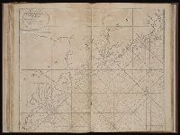
Beinecke Rare Book and Manuscript Library > A large draft of South Carolina from Cape Roman to Port Royall
Call Number:
1973 Folio 114
Collection Title:
The English pilot: describing the West-India navigation, from Hudson's-Bay to the river Amazones
Image Count:
1
Resource Type:
Maps, Atlases & Globes
Subject (Geographic):
Atlantic Ocean --Maps --Early works to 1800 and South Carolina --Maps --Early works to 1800
Subject (Topic):
Navigation --Early works to 1800, Pilot guides --Atlantic Coast (U.S.) --Early works to 1800, and Pilot guides --Caribbean Area --Early works to 1800
Collection Created:
London : Printed for W. and J. Mount, T. Page and son, on Tower-Hill, MDCCLIX [1759]
Found in:
Beinecke Rare Book and Manuscript Library > A large draft of South Carolina from Cape Roman to Port Royall
Call Number:
1978 Folio 10
Collection Title:
The English pilot: describing the West-India navigation, from Hudson's-Bay to the river Amazones
Image Count:
1
Subject (Geographic):
Antigua --Maps --Early works to 1800, Atlantic Ocean --Maps --Early works to 1800, and West Indies --Maps --Early works to 1800
Subject (Topic):
Navigation --Early works to 1800, Pilot guides --Atlantic Coast (U.S.) --Early works to 1800, and Pilot guides --Caribbean Area --Early works to 1800
Collection Created:
London : Printed for Thomas Page, William and Fisher Mount, in Postern-Row on Tower-hill, MDCCXXV [1725]
Found in:
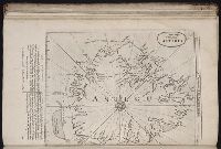
Beinecke Rare Book and Manuscript Library > A large draft of the island Antegua
Call Number:
1973 Folio 116
Collection Title:
The English pilot: describing the West-India navigation, from Hudson's-Bay to the river Amazones
Image Count:
1
Subject (Geographic):
Antigua --Maps --Early works to 1800, Atlantic Ocean --Maps --Early works to 1800, and West Indies --Maps --Early works to 1800
Subject (Topic):
Navigation --Early works to 1800, Pilot guides --Atlantic Coast (U.S.) --Early works to 1800, and Pilot guides --Caribbean Area --Early works to 1800
Collection Created:
London :
Found in:
Beinecke Rare Book and Manuscript Library > A large draft of the island Antegua
Call Number:
1973 Folio 114
Collection Title:
The English pilot: describing the West-India navigation, from Hudson's-Bay to the river Amazones
Image Count:
1
Resource Type:
Maps, Atlases & Globes
Subject (Geographic):
Antigua --Maps --Early works to 1800, Atlantic Ocean --Maps --Early works to 1800, and West Indies --Maps --Early works to 1800
Subject (Topic):
Navigation --Early works to 1800, Pilot guides --Atlantic Coast (U.S.) --Early works to 1800, and Pilot guides --Caribbean Area --Early works to 1800
Collection Created:
London : Printed for W. and J. Mount, T. Page and son, on Tower-Hill, MDCCLIX [1759]
Found in:
Beinecke Rare Book and Manuscript Library > A large draft of the island Antegua
Call Number:
1974 Folio 72
Collection Title:
The English pilot: describing the West-India navigation, from Hudson's-Bay to the river Amazones
Image Count:
1
Subject (Geographic):
Antigua --Maps --Early works to 1800, Atlantic Ocean --Maps --Early works to 1800, and West Indies --Maps --Early works to 1800
Subject (Topic):
Navigation --Early works to 1800, Pilot guides --Atlantic Coast (U.S.) --Early works to 1800, and Pilot guides --Caribbean Area --Early works to 1800
Collection Created:
London : Printed for W. and J. Mount, T. Page and son, on Tower-Hill, MDCCLX [1760]
Found in:
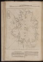
Beinecke Rare Book and Manuscript Library > A large draft of the island of Antegua
Call Number:
1978 Folio 10
Collection Title:
The English pilot: describing the West-India navigation, from Hudson's-Bay to the river Amazones
Image Count:
1
Subject (Geographic):
Atlantic Ocean --Maps --Early works to 1800, Boston (Mass.) --Maps --Early works to 1800, Boston Harbor (Mass.) --Maps --Early works to 1800, New England --Maps --Early works to 1800, and New York (State) --Maps --Early works to 1800
Subject (Topic):
Navigation --Early works to 1800, Pilot guides --Atlantic Coast (U.S.) --Early works to 1800, and Pilot guides --Caribbean Area --Early works to 1800
Collection Created:
London : Printed for Thomas Page, William and Fisher Mount, in Postern-Row on Tower-hill, MDCCXXV [1725]
Found in:
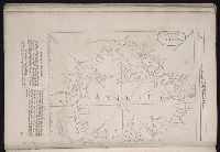
Beinecke Rare Book and Manuscript Library > A large draught of New England, New York, and Long Island
Call Number:
1976 1233
Collection Title:
Forty-two new maps of Asia, Africa, and America ... : all engrav’d, according to the latest
Image Count:
1
Alternative Title:
America in general
Description:
In ink on verso: 23.
Subject (Geographic):
America --Maps --Early works to 1800, North America --Maps --Early works to 1800, and South America --Maps --Early works to 1800
Subject (Name):
Nicholson, John, d. ca. 1717, bookseller
Subject (Topic):
Atlases --Early works to 1800
Collection Created:
London : Printed for J. Nicholson ..., 1716 ...
Found in:
Beinecke Rare Book and Manuscript Library > A map of America according to ye newest and most exact observations
Creator:
Published / Created:
1786 January 1
Call Number:
1982 Folio 10
Image Count:
1
Description:
Also appeared in Faden's [General atlas. London : William Faden, 1811?]., Imperfect: torn along fold, with no loss of text., No. 31 of 43 maps bound together in composite atlas., Relief shown pictorially., Scale [ca. 1:480,000]., and Sheets pasted together to form 1 sheet.
Publisher:
Printed for Wm. Faden
Subject (Geographic):
India, Northeastern --Maps --Early works to 1800
Found in:
Beinecke Rare Book and Manuscript Library > A map of Bengal, Bahar, Oude & Allahabad with part of Agra and Delhi : exhibiting the course of the Ganges from Hurdwar to the sea
Branch:v1.61.8 ,Deployed:2024-06-20T11:14:55-04:00