Germany. Heer. Abteilung für Kriegskarten- und Vermessungswesen. IV. Mil.-Geo
Published / Created:
1942
Call Number:
32 M312 1942
Container / Volume:
BRBL_00052
Image Count:
14
Resource Type:
Maps, Atlases & Globes
Alternative Title:
England 1:10 000 ; GB 4, BB 12e, 12f, 12g, 12h, 12i, 12k, 12l, 12m, 12n, 12o, 12p, 12q, 12r, 12s and Stadtplan von Manchester mit Mil.-Geo.-Eintragungen
Description:
"Militärgeogr. Angaben nach den bis zum 15. III. 1942 vorhandenen Unterlagen.", Relief shown by contours, hachures, and spot heights., and Shows features of military interest.
Publisher:
Generalstab des Heeres, Abteilung für Kriegskarten- u. Vermessungswesen (IV Mil.-Geo.),
"To accompany the Commissioner's joint report dated November 26, 1951. Upon the establishment of the boundary from Tongass Passage to Mount St. Elias in accordance with the convention of January 24, 1903, the award of the tribunal, appointed under the convention signed at London October 20, 1903 ..."
Publisher:
U.S. G.P.O.,
Subject (Geographic):
Alaska--Boundaries--Canada--Maps, Canada--Boundaries--United States--Maps, and United States--Boundaries--Canada--Maps
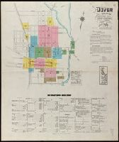
Fire insurance map, colored to show building construction, property boundaries and house and block numbers.
Alternative Title:
Dover, Del., Dover, Delaware, and June 1919, Dover, Del.
Description:
"15 sheets (2729).", Coordinates not present on map and are approximated., Includes index to streets and buildings., Sheet 1 includes key to building colors and other features of construction, water facilities and fire department, index map for the adjoining sheets., and Stamps on sheet 1: CLF 33650; Sep. 9, 1919.
Publisher:
Sanborn Map Company,
Subject (Geographic):
Dover (Del.)--Maps.
Subject (Topic):
Fire risk assessment--Delaware--Dover--Maps. and Real property--Delaware--Dover--Maps.
Includes 5 insets, var. scales: Hypsometrical and bathymetrical chart -- Political division of the Japanese Empire -- Chishima (Kurile Islands) -- [Taiwan and Ryūkyū Islands] -- Ogasawa-Jima (Bonin Islands), Ka and Relief shown by contours and spot heights.
Publisher:
Tōyōdō,
Subject (Geographic):
Japan--Administrative and political divisions--Maps, Japan--Maps, and Taiwan--Maps
Subject (Name):
Matsudaira, N, Suzuki, Kiyotada, and Togawa, Tametsugu
Fire insurance map, colored to show building construction, property boundaries and house and block numbers.
Alternative Title:
Milford, Del., Milford, Delaware, and Nov. 1919, Milford, Del.
Description:
"15 sheets (2932).", Coordinates not present on map and are approximated., Includes index to streets and buildings., Sheet 1 includes key to building colors and other features of construction, water facilities and fire department, index map for the adjoining sheets., and Stamps below title: CLF 33891; Feb. 13, 1920.
Publisher:
Sanborn Map Company,
Subject (Geographic):
Milford (Del.)--Maps.
Subject (Topic):
Fire risk assessment--Delaware--Milford--Maps. and Real property--Delaware--Milford--Maps.
Contents: The environs of London, reduced from an actual survey, in 16 sheets, by the late John Rocque ... with new improvements to the year 1763. - An exact survey of the city's of London, Westminster, ye borough of Southwark and the country near ten mil