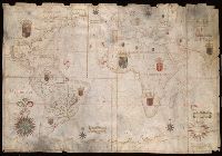
"Feita por João Teix[ei]ra Albernass Cosmographo los Reinos de Portugal por Sua Mag[esta]de. O anno de 1665. L[i]x[bo]a", Contains five compass roses., Decoration: coats of arms in territories., Imperfect: chipped along edges., Manuscript annotations on verso., Pen-and-ink in black, red, blue, yellow and green., Portolan chart with seaport names given for all coastlines., and Title devised by cataloger.
Subject (Geographic):
Atlantic Ocean--Maps--Early works to 1800., Indian Ocean--Maps--Early works to 1800., and Pacific Ocean--Maps--Early works to 1800.
Subject (Topic):
Nautical charts--Atlantic Ocean--Early works to 1800., Nautical charts--Indian Ocean--Early works to 1800., and Nautical charts--Pacific Ocean--Early works to 1800.
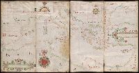
"Made by Nicholas Comberford dwelling neare to the way end of the school house at the signe of the Platt in Radcliffe, anno 1647.", Contains two and a half compass roses and four listings of indexed names., Decoration: city views with banners., Pen-and-ink in black, red, blue, green, yellow and gold., Portolan chart with seaport names given for all coastlines., Scale "containeth one hundreth English leagues after twentie to a degree.", and Title devised by cataloger.
Subject (Geographic):
Black Sea--Maps--Early works to 1800. and Mediterranean Sea--Maps--Early works to 1800.
Subject (Topic):
Nautical charts--Black Sea--Early works to 1800. and Nautical charts--Mediterranean Sea--Early works to 1800.
Following is the description of the chart from Auktion XXXVIII, p. 72, published by Haus der Bücher AG and L'Art Ancien S.A.: "Portolankarte. Anonyme portugiesische Seekarte von Teilen des atlantischen Ozeans. Portugal, 17. J and Title supplied by cataloger.
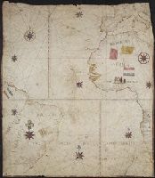
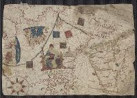
Color: pen and ink with green and blue shading., In the corner there is a table of the Florida and Cuban cays with their locations on the map. On the Island of Jamaica is marked Pta. Portland, presumably named after the Earl of Portland, councillor for trade and navigation, who died in 1663, or his son, who was killed fighting the Dutch in the battle off the Texel in 1665., On Jamaica the name "Kiniston" (Kingston) has been added early on, presumably about 1695, soon after its foundation, and in Hayti the name St. Luiz at a later period., and Spanish manuscript portolan chart on vellum. Unsigned and undated.
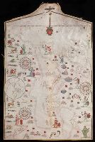
Colors: red, greens, and blues., Crucifix at top of map., Inset: The world., Joan Riezo figlo de mastro dominico [Olives] in missina año 1590., and Notes: gold ribbon along borders of map, missing from far right hand side.
Subject (Geographic):
Europe--Maps--Early works to 1800 and Mediterranean Sea--Maps--Early works to 1800
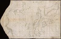
Contains five compass roses., Decoration: city views with banners, figures holding armorial shields, animals, and Jesus Christ on the cross flanked by the Virgin Mary and Mary Magdalene., Includes degrees of latitude along left edge: 18°N to 63°N., Includes two North Atlantic islands "Frislandia" and "Stilanda" in upper left corner and inset map of the world in the lower center., Pen-and-ink in black, red, blue and green., Portolan chart with seaport names given for all coastlines., and Title devised by cataloger; last two numerals of date have been altered.
Subject (Geographic):
Baltic Sea--Maps--Early works to 1800, Mediterranean Sea--Maps--Early works to 1800, and North Atlantic Ocean--Maps--Early works to 1800