Imray, James F. (James Frederick), 1829?-1891, cartographer James Imray and Son, issuing body
Call Number:
23cea 1886
Container / Volume:
BRBL_00021
Image Count:
2
Resource Type:
Maps, Atlases & Globes
Alternative Title:
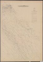
Western Pacific, sheet no. 4
Description:
Hydrographic chart of the western Pacific Ocean, including eastern Australia, Papua New Guinea, the Solomon Islands, New Hebrides, New Caledonia, and the northwest of New Zealand., Mellish Reef., and Relief shown by hachures and spot heights. Depth shown by iso
Subject (Geographic):
Melanesia--Maps and Pacific Ocean--Maps
Subject (Topic):
Nautical charts--Melanesia and Nautical charts--Pacific Ocean
I, Includes sailing directions., Map of the western shore of the Bay of Yedo, Japan with relief shown by hachures. Depth shown by soundings., and Views: Perry I. W.-Mt. Fusee-Webster I. N.W. by W. -- Uraga-Cape Kamisaki -- Saddle N.E. 3/4 N-C. Sagami N.E. 3/4 E.
Publisher:
Hydrographic Dept.],
Subject (Geographic):
Japan--Maps
Subject (Name):
Bien, Julius, 1826-1909, Maury, William L, Perry, Matthew Calbraith, 1794-1858, Sels, Edward, Siebert, Selmar, and United States Naval Expedition to Japan--1852-1854
DLC, Includes notes., and The whale chart was released as series F a part of Maury's "Wind and current charts", series A-F. For complete discussion, see "The wind and current chart series produced by Matthew Fontaine Maury," by Marc I. Pinsel, in Navigation : J
Publisher:
National Observatory,
Subject (Name):
Maury, Matthew Fontaine, 1806-1873. Wind and current charts, United States Naval Observatory, United States. Bureau of Ordnance and Hydrography, W. Endicott & Co, and Warrington, L. (Lewis), 1782-1851
Subject (Topic):
Right whales--Maps, Sperm whale--Maps, Whales--Maps, and Whaling--Maps
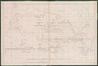
[Maury map collection ; Series D1], Maury's wind & current chart : thermal sheet., North Atlantic, and Thermal sheet
Description:
"Series D.", DLC, Includes notes in map area and signature of M.F. Maury., Sheet 1 (1850), 3 copies -- Sheet 1 (1852) -- Sheet 2, 2 copies -- Sheet 3, 3 copies -- Sheet 4, 3, Shows temperature of the water at the surface by month., and Various eds. of some sheets.
Publisher:
United States Hydrographical Office,
Subject (Geographic):
North Atlantic Ocean--Maps
Subject (Name):
Gantt, Benjamin S., -1852, Maury, Matthew Fontaine, 1806-1873. Wind and current charts, United States Naval Observatory, United States. Bureau of Ordnance and Hydrography, United States. Hydrographic Office, and Warrington, L. (Lewis), 1782-1851
Subject (Topic):
Nautical charts--North Atlantic Ocean and Ocean temperature--North Atlantic Ocean--Maps
[Maury map collection ; Series D1], Maury's wind & current chart : thermal sheet., North Atlantic, and Thermal sheet
Description:
Copy imperfect: Sheet torn and repaired along fold-line and edges. Discoloration throughout., Each sheet numbered in upper left margin, e.g.: 14, 15., Includes notes in map area and signature of M.F. Maury., and Sheet 1 (1850), 3 copies -- Sheet 1 (1852) -- Shee
Publisher:
United States Hydrographical Office,
Subject (Geographic):
North Atlantic Ocean--Maps
Subject (Name):
Gantt, Benjamin S., -1852, Maury, Matthew Fontaine, 1806-1873. Wind and current charts, United States Naval Observatory, United States. Bureau of Ordnance and Hydrography, United States. Hydrographic Office, and Warrington, L. (Lewis), 1782-1851
Subject (Topic):
Nautical charts--North Atlantic Ocean and Ocean temperature--North Atlantic Ocean--Maps
[Maury map collection ; Series D1], Maury's wind & current chart : thermal sheet., North Atlantic, and Thermal sheet
Description:
Copy imperfect: Sheet torn and repaired along fold-line and edges. Discoloration throughout., Each sheet numbered in upper left margin, e.g.: 14, 15., and Sheet 1 (1850), 3 copies -- Sheet 1 (1852) -- Sheet 2, 2 copies -- Sheet 3, 3 copies -- Sheet 4, 3 copies
Publisher:
United States Hydrographical Office,
Subject (Geographic):
North Atlantic Ocean--Maps
Subject (Name):
Gantt, Benjamin S., -1852, Maury, Matthew Fontaine, 1806-1873. Wind and current charts, United States Naval Observatory, United States. Bureau of Ordnance and Hydrography, United States. Hydrographic Office, and Warrington, L. (Lewis), 1782-1851
Subject (Topic):
Nautical charts--North Atlantic Ocean and Ocean temperature--North Atlantic Ocean--Maps
[Maury map collection ; Series D1], Maury's wind & current chart : thermal sheet., North Atlantic, and Thermal sheet
Description:
DLC, Each sheet numbered in upper left margin, e.g.: 14, 15., Includes notes in map area and signature of M.F. Maury., Shows temperature of the water at the surface by month., and Thermal charts were released as series D a part of Maury's "Wind and current charts
Publisher:
United States Hydrographical Office,
Subject (Geographic):
North Atlantic Ocean--Maps
Subject (Name):
Gantt, Benjamin S., -1852, Maury, Matthew Fontaine, 1806-1873. Wind and current charts, United States Naval Observatory, United States. Bureau of Ordnance and Hydrography, United States. Hydrographic Office, and Warrington, L. (Lewis), 1782-1851
Subject (Topic):
Nautical charts--North Atlantic Ocean and Ocean temperature--North Atlantic Ocean--Maps
[Maury map collection ; Series A4], Maury's wind & current chart, North Pacific, Maury's wind and current chart, North Pacific, North Pacific, and Wind and current chart, North Pacific
Description:
"Lith. of J. Bien, 180 Broadway N.Y."--Sheets 6 and 10, lower right margin., "Series A.", Complete in 10, Copy imperfect: All sheets fold lined, with some tears along fold-line. Sheet 4 discoloration throughout, mounted on cloth backing., DLC, and Includes notes.
Publisher:
United States Hydrographical Office,
Subject (Geographic):
North Pacific Ocean--Charts, diagrams, etc
Subject (Name):
Bien, Julius, 1826-1909, Fillebrown, Thomas Scott, 1834-1884, Gibbon, Lardner, Johnson, A. W, Maury, Matthew Fontaine, 1806-1873. Wind and current charts, Porter, B. S, United States Naval Observatory, United States. Bureau of Ordnance and Hydrography, and United States. Hydrographic Office
[Maury map collection ; Series A4], Maury's wind & current chart, North Pacific, Maury's wind and current chart, North Pacific, North Pacific, and Wind and current chart, North Pacific
Description:
Sheet 1 (not issued) -- Sheet 2 (1851) -- Sheet 3 (1850) -- Sheet 4 (no date) -- Sheet 5 (1849) -- Sheet 6 (no date) -- Sheet 7 (no date) -- Sheet 8 (no date) -- Sheet 9 (no date) -- Sheet 10 (1852) -- Sheet 11 (1852). and Shows prevailing wind direction by m
Publisher:
United States Hydrographical Office,
Subject (Geographic):
North Pacific Ocean--Charts, diagrams, etc
Subject (Name):
Bien, Julius, 1826-1909, Fillebrown, Thomas Scott, 1834-1884, Gibbon, Lardner, Johnson, A. W, Maury, Matthew Fontaine, 1806-1873. Wind and current charts, Porter, B. S, United States Naval Observatory, United States. Bureau of Ordnance and Hydrography, and United States. Hydrographic Office
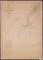
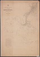
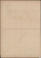
[Maury map collection ; Series D2], Maury's wind & current chart : South Atlantic, and South Atlantic
Description:
"Series D.", Copy imperfect: Sheets 1-4 torn and repaired along fold line, Does not cover the southeastern Atlantic south of latitude 40° S., and Originally intended to be complete in 6 sheets. Sheets 5 and 6, covering the southeastern Atlantic, were not issued.
Publisher:
United States Hydrographical Office,
Subject (Geographic):
South Atlantic Ocean--Maps
Subject (Name):
Maury, Matthew Fontaine, 1806-1873. Wind and current charts, Morris, Charles, 1784-1856, United States Naval Observatory, United States. Bureau of Ordnance and Hydrography, and United States. Hydrographic Office
Subject (Topic):
Nautical charts--South Atlantic Ocean and Ocean temperature--South Atlantic Ocean--Maps