
You Searched For
« Previous
| 1 - 10 of 229 |
Next »
Search Results

2.

- Published / Created:
- Undated
- Call Number:
- 1973 Folio 10
- Image Count:
- 1
- Resource Type:
- Maps, Atlases & Globes
- Description:
- Additional map not listed on manuscript contents page.
- Subject (Geographic):
- Rhine River
- Found in:
- Beinecke Rare Book and Manuscript Library > A view of Prince Charles's passage over ye Rhine being a new and correct plan of that river from ye city of Maintz to Fort Louis
- Creator:
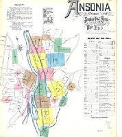
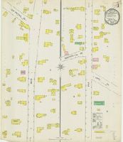
- Sanborn-Perris Map Co., issuing body
- Published / Created:
- 1890
- Call Number:
- 766 An81 1890
- Image Count:
- 13
- Resource Type:
- Maps, Atlases & Globes
- Abstract:
- Sanborn fire insurance maps are a rich source of historic data on the urban built environment of North America during the 19th and early 20th centuries. The atlases were created for the purpose of underwriting fire insurance policies, which depended upon accurate and frequently-updated information about construction materials, municipal and transportation infrastructure, industrial and commercial landuse and more. The Yale University Library Map Department scanned its holdings of Sanborn fire insurance maps (consisting primarily of Connecticut towns) in order to make the maps more accessible.
- Alternative Title:
- Ansonia, Connecticut and Dec. 1890, Ansonia, Conn.
- Description:
- "13 sheets (4176).", Contains information on population, water facilities, and fire department., Includes index of streets and specials., Partial cadastral map., and SMLMAPL 766 An81 1890: Sheets disbound. "Triplicate" stamp on all sheets. Library of Congress copyright stamp on title sheet.
- Subject (Geographic):
- Ansonia (Conn.)--Maps
- Subject (Name):
- Library of Congress Stamp
- Subject (Topic):
- Fire risk assessment--Connecticut--Ansonia--Maps and Real property--Connecticut--Ansonia--Maps
- Found in:
- Beinecke Rare Book and Manuscript Library > Ansonia, New Haven Co., Connecticut.
- Creator:
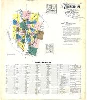
- Sanborn Map Company, issuing body
- Published / Created:
- 1924
- Call Number:
- 766 An81 1924
- Image Count:
- 39
- Resource Type:
- Maps, Atlases & Globes
- Abstract:
- Sanborn fire insurance maps are a rich source of historic data on the urban built environment of North America during the 19th and early 20th centuries. The atlases were created for the purpose of underwriting fire insurance policies, which depended upon accurate and frequently-updated information about construction materials, municipal and transportation infrastructure, industrial and commercial landuse and more. The Yale University Library Map Department scanned its holdings of Sanborn fire insurance maps (consisting primarily of Connecticut towns) in order to make the maps more accessible.
- Alternative Title:
- Ansonia, Connecticut and Mar. 1924, Ansonia, Conn.
- Description:
- "39 sheets (1516).", Contains information on population, prevailing winds, water facilities, and fire department., Includes index of streets and specials., Partial cadastral map., and SMLMAPL 766 An81 1924: Sheets disbound.
- Subject (Geographic):
- Ansonia (Conn.)--Maps
- Subject (Topic):
- Fire risk assessment--Connecticut--Ansonia--Maps and Real property--Connecticut--Ansonia--Maps
- Found in:
- Beinecke Rare Book and Manuscript Library > Ansonia, New Haven Co., Connecticut.

- Creator:
- Tuttle-Ayers-Woodward Co
- Call Number:
- 816ad K134 1925
- Container / Volume:
- BRBL_00563
- Image Count:
- 29
- Resource Type:
- Maps, Atlases & Globes
- Description:
- Imperfect: incomplete, 29 plates on 19 sheets.
- Publisher:
- The Company,
- Subject (Geographic):
- Jackson County (Mo.)--Maps and Kansas City (Mo.)--Maps
- Subject (Topic):
- Real property--Missouri--Jackson County--Maps and Real property--Missouri--Kansas City--Maps
- Found in:
- Beinecke Rare Book and Manuscript Library > Atlas of Kansas City, Missouri, and environs, 1925.
- Creator:
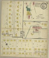
- Sanborn Map Company, issuing body
- Published / Created:
- 1911
- Call Number:
- 766 B217 1911
- Image Count:
- 3
- Resource Type:
- Maps, Atlases & Globes
- Abstract:
- Sanborn fire insurance maps are a rich source of historic data on the urban built environment of North America during the 19th and early 20th centuries. The atlases were created for the purpose of underwriting fire insurance policies, which depended upon accurate and frequently-updated information about construction materials, municipal and transportation infrastructure, industrial and commercial landuse and more. The Yale University Library Map Department scanned its holdings of Sanborn fire insurance maps (consisting primarily of Connecticut towns) in order to make the maps more accessible.
- Alternative Title:
- Baltic, Connecticut and May 1911, Baltic, Conn.
- Description:
- "3738, 3 sheets.", Contains information on population, prevailing winds, water facilities and fire department., Includes index of specials., Partial cadastral map., and SMLMAPL 766 B217 1911: Imperfect: sheet slightly chipped and torn, with no loss of text. Sheets disbound.
- Subject (Geographic):
- Sprague (Conn. : Town)--Maps
- Subject (Topic):
- Fire risk assessment--Connecticut--Sprague (Town)--Maps and Real property--Connecticut--Sprague (Town)--Maps
- Found in:
- Beinecke Rare Book and Manuscript Library > Baltic, New London County, Connecticut.

- Creator:
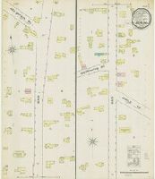
- Sanborn Map Company, issuing body
- Published / Created:
- 1932
- Call Number:
- 766 B217 1932
- Image Count:
- 5
- Resource Type:
- Maps, Atlases & Globes
- Abstract:
- Sanborn fire insurance maps are a rich source of historic data on the urban built environment of North America during the 19th and early 20th centuries. The atlases were created for the purpose of underwriting fire insurance policies, which depended upon accurate and frequently-updated information about construction materials, municipal and transportation infrastructure, industrial and commercial landuse and more. The Yale University Library Map Department scanned its holdings of Sanborn fire insurance maps (consisting primarily of Connecticut towns) in order to make the maps more accessible.
- Alternative Title:
- Baltic, Conn., Jan. 1932 and Baltic, Connecticut
- Description:
- "(1530).", "(5 sheets).", Contains information on population, prevailing winds, water facilities and fire department., Includes index of streets and specials., Partial cadastral map., and SMLMAPL 766 B217 1932: Imperfect: sheet 1 slightly chipped, with no loss of text. Sheets disbound.
- Subject (Geographic):
- Sprague (Conn. : Town)--Maps
- Subject (Topic):
- Fire risk assessment--Connecticut--Sprague (Town)--Maps and Real property--Connecticut--Sprague (Town)--Maps
- Found in:
- Beinecke Rare Book and Manuscript Library > Baltic, New London County, Connecticut.

- Creator:
- Cassini, Cesar-Francois, 1714-1784
Homann Erben (Firm)
Mayer, Tobias, 1723-1762
Snellius, Willebrord, 1580-1626 - Call Number:
- 1973 Folio 30
- Collection Title:
- [Atlas factice of 32 maps and 1 distance table, produced by the Homann Erben firm]
- Image Count:
- 2
- Alternative Title:
- Belgium Catholicum seu decem provinciae Germaniae inferioris and Carte des Pais Bas catholiques ou des X provinces de l’Allegmagne inferieure, etc. dessinee au juste selon les exactes observations astronomiques et operations geometriques des Messur. Cassini, Snellius, Muschenbrok, etc. dressee par Sr. Tobias Maier, mathematicien; aux depens des Heritiers de Homann
- Subject (Geographic):
- Belgium --Maps --Early works to 1800 and Luxembourg --Maps --Early works to 1800
- Subject (Topic):
- Atlases, German --Early works to 1800
- Collection Created:
- [Nuremberg : s.n.,
- Found in:
- Beinecke Rare Book and Manuscript Library > Belgivm Catholicvm seu decem provinciae Germaniae inferioris : cum confiniis Germaniae svp. et Franciae legitime omnia delineata et ad ductum observationum astronomicarum, nec non geometricarum operationum a Cassinio Snellio Muschenbrokio aliisqve rite ha
- Creator:
- Sanborn Map & Publishing Co., issuing body
- Published / Created:
- 1887
- Call Number:
- 766 B45 1887
- Image Count:
- 2
- Resource Type:
- Maps, Atlases & Globes
- Abstract:
- Sanborn fire insurance maps are a rich source of historic data on the urban built environment of North America during the 19th and early 20th centuries. The atlases were created for the purpose of underwriting fire insurance policies, which depended upon accurate and frequently-updated information about construction materials, municipal and transportation infrastructure, industrial and commercial landuse and more. The Yale University Library Map Department scanned its holdings of Sanborn fire insurance maps (consisting primarily of Connecticut towns) in order to make the maps more accessible.
- Alternative Title:
- Nov. 1887, Berlin, Conn.
- Description:
- "2 sheets.", Contains information on population, prevailing winds, water facilities and fire department., Partial cadastral map., and SMLMAPL 766 B45 1887: Sheets disbound. "Triplicate" stamp on all sheets.
- Subject (Geographic):
- Berlin (Conn.)--Maps
- Subject (Topic):
- Fire risk assessment--Connecticut--Berlin--Maps and Real property--Connecticut--Berlin--Maps
- Found in:
- Beinecke Rare Book and Manuscript Library > Berlin, Conn.
- Creator:
- Sanborn-Perris Map Co., issuing body
- Published / Created:
- 1895
- Call Number:
- 766 B45 1895
- Image Count:
- 3
- Resource Type:
- Maps, Atlases & Globes
- Abstract:
- Sanborn fire insurance maps are a rich source of historic data on the urban built environment of North America during the 19th and early 20th centuries. The atlases were created for the purpose of underwriting fire insurance policies, which depended upon accurate and frequently-updated information about construction materials, municipal and transportation infrastructure, industrial and commercial landuse and more. The Yale University Library Map Department scanned its holdings of Sanborn fire insurance maps (consisting primarily of Connecticut towns) in order to make the maps more accessible.
- Alternative Title:
- Aug. 1895, Berlin, Conn. and Berlin, Conn.
- Description:
- "3 sheets, 8118.", Contains information on population, prevailing winds, water facilities and fire department., Partial cadastral map., and SMLMAPL 766 B45 1895: Sheets disbound. "Triplicate" stamp on all sheets. Library of Congress copyright stamp on title sheet.
- Subject (Geographic):
- Berlin (Conn.)--Maps
- Subject (Name):
- Library of Congress Stamp
- Subject (Topic):
- Fire risk assessment--Connecticut--Berlin--Maps and Real property--Connecticut--Berlin--Maps
- Found in:
- Beinecke Rare Book and Manuscript Library > Berlin, Hartford Co., Conn.