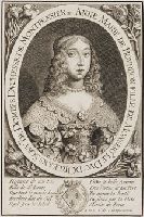
Portrait of Anne Marie Louise de Bourbon, daughter of Gaston Duke of Orléans; half-length, slightly turned to right and looking towards the viewer, wavy hair tumbling about her shoulders, and a gown with a lace collar
Alternative Title:
Anne Marie de Bourbon ...
Description:
Title engraved within oval border., Place and date of publication supplied by cataloger., Ten lines of verse engraved below image, five on either side of the Duke of Orléans's arms: Resource de nos lis, fille de St. Louis, que tout le monde honore ..., "A.D.V. Sr. de Champ-courtois"--Lower right corner., Sheet trimmed within plate mark., Mounted on page 63 of Richard Bull's copiously extra-illustrated copy of: Walpole, H. A description of the villa of Mr. Horace Walpole. Strawberry Hill : Printed by Thomas Kirgate, 1784. See Hazen, A.T. Bibliography of the Strawberry Hill Press (1973 ed.), no. 30, copy 13., and For further information, consult library staff.
Publisher:
publisher not identified
Subject (Name):
Montpensier, Anne-Marie-Louise d'Orléans, duchesse de, 1627-1693,
Bellin, Jacques Nicolas, 1703-1772, creator France, Depot des cartes et plans de la marine
Published / Created:
1755?
Call Number:
2003 Folio 85
Image Count:
1
Description:
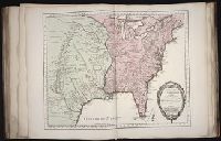
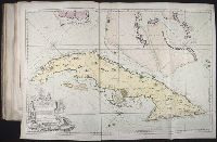
Available also through the Library of Congress Web site as a raster image., BEIN 2003 Folio 85: No. 23 of 45 maps bound together with binder's spine title: Atlas of America; ms. table of contents. Bookplate: Robinson. Bookplate of Paul Mellon., Covers the area from Quebec to the Gulf of Mexico and west of Santa Fe, N.M., Hand colored., LC Maps of North America, 1750-1789,, Longitude du meridien de l'ile de Fer., Par le Sr. Bellin, ingr. ordre. de la marine, 1750., Relief shown pictorially., Scale [ca. 1:5,800,000]., Shows cities and towns, forts, some trails, and Indian villages and tribal territory., and Sur de nouvelles observations on a corrige les lacs, et leurs environs, 1755.
Subject (Geographic):
Louisiana -- Maps -- Early works to 1800 and North America -- Maps -- Early works to 1800
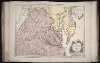
Fry, Joshua, 1700 (ca.)-1754 Haussard, Elisabeth. Jefferson, Peter, 1708-1757 Robert de Vaugondy, Gilles, 1688-1766 Robert de Vaugondy, Gilles, 1688-1766, creator
Published / Created:
1755
Call Number:
2003 Folio 85
Image Count:
1
Description:
BEIN 2003 Folio 85: No. 22 of 45 maps bound together with binder's spine title: Atlas of America; ms. table of contents. Bookplate: Robinson. Bookplate of Paul Mellon., dressee sur la grande carte angloise de Mrs. Josue Fry et Pierre Jefferson ; par le Sr. Robert de Vaugondy, geographe ordinaire du Roi., Grave E. Haussard., Hand colored., Relief shown pictorially., Scale [ca. 1:870,000], and Shows Virginia, Maryland, and De La War counties.
Subject (Geographic):
Maryland -- Maps -- 1755, Maryland -- Maps -- Early works to 1800, Middle Atlantic States -- Maps -- 1755, Middle Atlantic States -- Maps -- Early works to 1800, Virginia -- Maps -- 1755, and Virginia -- Maps -- Early works to 1800
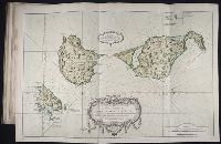
BEIN 2003 Folio 85: No. 11 of 45 maps bound together with binder's spine title: Atlas of America; ms. table of contents. Bookplate: Robinson. Bookplate of Paul Mellon., Hand colored., Leve sure les lieux a 6 lignes pour cent toises par le Sr Fortin, ingenieur geographe., par le Sr. Bellin, ingenieur de la Marine., Relief shown pictorially. Depths shown by soundings., and Scale [ca. 1:50,000].
Publisher:
s.n
Subject (Topic):
Coasts -- Saint Pierre and Miquelon -- Maps -- Early works to 1800 and Nautical charts -- Saint Pierre and Miquelon -- Early works to 1800
Bellin, Jacques Nicolas, 1703-1772, creator Choiseul, Etienne-Francois, duc de, 1719-1785 France, Depot des cartes et plans de la marine
Published / Created:
1762?
Call Number:
2003 Folio 85
Image Count:
1
Description:
BEIN 2003 Folio 85: No. 29 of 45 maps bound together with binder's spine title: Atlas of America; ms. table of contents. Bookplate: Robinson. Bookplate of Paul Mellon., dressee au Depot des cartes et plans de la marine pour la service des vaisseaux du Roy ; par ordre de M. le duc de Choiseul, colonel general des suisses et grisons, ministre de la guerre et de la marine ; par le S. Bellin, ingenieur de la marine et du Depost des plans, censeur royal de l'Academie de marine et de la Societe royale de Londres, M.DCC.LXII., Hand colored., Relief shown pictorially. Depths shown by soundings., and Scale [ca. 1:1,250,000].
BEIN 2003 Folio 85: No. 8 of 45 maps bound together with binder's spine title: Atlas of America; ms. table of contents. Bookplate of Paul Mellon., dressee au depost des cartes, plans et journaux de la marine pour le service des vaisseaux du Roi ; par ordre de M. Rouille., Hand-colored., Relief shown pictorially; depths shown by soundings., and Scale not given.
Subject (Geographic):
Saint Lawrence, Gulf of -- Maps -- Early works to 1800
Subject (Topic):
Nautical charts -- Saint Lawrence, Gulf of -- Early works to 1800
Captions below each of three images of full-length images of men in fashionable styles of the period: Habillement a l'anglaise ; Habit de cour ; Costume d'é́té́ et chapeau suisse
Description:
Title etched above image; subtitle below captions. and Plate from?: Gourdon de Genouillac, H. Paris à travers les siècles (Paris : F. Roy, 1840-1882).