Forty-two new maps of Asia, Africa, and America ... : all engrav’d, according to the latest
Image Count:
1
Alternative Title:
A chart of the coasts of Peru, &c
Description:
In pencil on verso: 29. and Table of contents for maps 2-20 in section "America" misnumbered.
Subject (Geographic):
Darien (Panama and Colombia) --Early works to 1800, Peru --Maps --Early works to 1800, Popayan (Colombia), Quito (Ecuador) --Maps, and South America --Maps --Early works to 1800
Also appeared in Faden's [General atlas. London : William Faden, 1811?]., Depths shown by soundings., No. 13 of 43 maps bound together in composite atlas., Scale [ca. 1:3,200,000]., and Shows ports, sailing directions, etc.
Publisher:
Engraved & published by Wm. Faden
Subject (Geographic):
Mediterranean Sea --Maps --Early works to 1800
Subject (Topic):
Coasts --Africa, North --Maps --Early works to 1800, Coasts --Portugal --Maps --Early works to 1800, Coasts --Spain --Maps --Early works to 1800, Nautical charts --Africa, North --Early works to 1800, Nautical charts --Mediterranean Sea --Early works to 1800, Nautical charts --Portugal --Early works to 1800, and Nautical charts --Spain --Early works to 1800
Also appeared in Faden's [General atlas. London : William Faden, 1811?]., Includes 11 coastal profiles., No. 9 of 43 maps bound together in composite atlas., Relief shown by hachures; depths by soundings., Scale [ca. 1:364,000]., and Shows rocks and redoubts or guardhouses on the French coast, anchorages, etc.
Publisher:
W. Faden
Subject (Geographic):
Brittany (France) --Maps --Early works to 1800, Channel Islands --Maps --Early works to 1800, and Normandy (France) --Maps --Early works to 1800
Subject (Topic):
Coasts --France --Brittany --Maps --Early works to 1800, Coasts --France --Normandy --Maps --Early works to 1800, Nautical charts --Channel Islands --Early works to 1800, Nautical charts --France --Brittany --Early works to 1800, and Nautical charts --France --Normandy --Early works to 1800
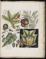
14. Cupressus Americana. The cypress of America|15. Liquid-ambari arbor / The sweet gum-tree|16. Arbor tulipifera Virginiana. The tulip-tree|19. Arbor in aqua nascens ... The water tupelo.
, 23. Cornus mas Virginiana ... The Dogwood-tree|24. Amelanchior Virginiana ... The Fringe-tree|25. Agrifolium Carolinense ... The Dahoon Holly|26. Cassena vera Floridanorum ... The Yapon., 27. Arbor in aqua nascens ... The Tupelo-tree|28. Laurus Carolinensis ... The Red Bay|29. Ligustrum Lauri folio ... The Purple-berried Bay|30. Cornus mas odorato ... The Sassafras-tree., 39. Frutex foliis oblongis acuminatis ... The Sorrel-tree|40. Pseudo-acacia hispida floribus roseis = The Acacia with rose-coloured flowers|41. Myrtus Brabantice similis Caroliniensis ... The Candle-berry Myrtle|42. Acacia, abruae foliis ... The Water Acacia., 55. Cistus Virginiana, flore & periclymini = The Upright Honey-suckle|56. Jasminum luteum odoratum Virginianum ... The Yellow Jessamin|57. Hamamelis|58. Frutex cornii foliis conjugatis; floribus instar anemones stellatae, petalis crassis, rigidis, colore sordide rubente; cortice aromatico., Hortus Britanno-Americanus., and Hortus Europae americanus: or, A collection of 85 curious trees and shrubs, the produce of North America; : adapted to the climates and soils of Great B
BEIN 2003 Folio 85: No. 7 of 45 maps bound together with binder's spine title: Atlas of America; ms. table of contents. Bookplate of Paul Mellon., Engraved by: Thomas Jefferys, geographer to his majesty., Hand-colored., Kershaw, Kenneth. Early printed maps of Canada, vol. 4, no. 1015., Map shows details of British and French positions during the siege of Quebec and table of references identifies British military units., Overlay provides details of changed position of British troops at the battle of September 13, 1759., Published in: A general topography of North America, London, 1768., and Scale 1:18,500.
Publisher:
Thos. Jefferys, the corner of St. Martins Lane Charing Cross
Subject (Geographic):
QueÌbec (QueÌbec) -- Maps -- Early works to 1800, QueÌbec Campaign, 1759 -- Maps, and United States -- History -- French and Indian War, 1755-1763 -- Maps
Bowen, Emanuel, d. 1767 Cook, James, fl. 1766, creator
Published / Created:
Decr. 1766
Call Number:
2003 Folio 85
Image Count:
1
Description:
BEIN 2003 Folio 85: No. 24 of 45 maps bound together with binder's spine title: Atlas of America; ms. table of contents. Bookplate: Robinson. Bookplate of Paul Mellon., by their humble servt. James Cook ; approv'd of by Mr. Joiner 20 years a pilot of that place., Depths shown by soundings., Emanl. Bowen sculpt., Hand colored., and Scale [1:65,000].
Publisher:
By the author
Subject (Geographic):
Port Royal (S.C.) -- Maps -- Early works to 1800
Subject (Topic):
Nautical charts -- Port Royal (S.C.) -- Early works to 1800
Bowen, Emanuel, d. 1767 Cook, James, 1728-1779, creator
Published / Created:
Decem'r. 1766
Call Number:
2003 Folio 85
Image Count:
1
Description:
BEIN 2003 Folio 85: No. 15 of 45 maps bound together with binder's spine title: Atlas of America; ms. table of contents. Bookplate: Robinson. Bookplate of Paul Mellon., by James Cook, when surveyor of His Majesty's Ship the Mars., Depths shown by soundings., Eman'l. Bowen sculp't., Hand colored., and Scale [ca. 1:64,000].
Publisher:
Published by the author according to Act of Parliament
Subject (Geographic):
Halifax (N.S.) -- Maps -- Early works to 1800
Subject (Topic):
Coasts -- Nova Scotia -- Maps -- Early works to 1800 and Nautical charts -- Nova Scotia -- Early works to 1800
BEIN 2003 Folio 85: No. 26 of 45 maps bound together with binder's spine title: Atlas of America; ms. table of contents. Bookplate: Robinson. Bookplate of Paul Mellon., Cartouche with dedication to John Ellis, Esq., King's agent for the province of west Florida, by James Cook., Depths shown by soundings., Hand colored., Inserts are A plan of Pensacola Harbour with the marks for going in (scale 1:95,000) and A draught of Spirito Sancto and coast adjacent (scale ca. 1:140,000)., and Scale [ca. 1:550,000].
Publisher:
Published by the author according to Act of Parliament
Subject (Geographic):
Florida -- Maps -- Early works to 1800
Subject (Topic):
Coasts -- Florida -- Maps -- Early works to 1800 and Nautical charts -- Florida -- Early works to 1800