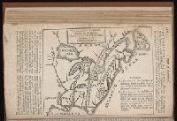
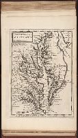
The English pilot: describing the West-India navigation, from Hudson's-Bay to the river Amazones
Image Count:
1
Resource Type:
Maps, Atlases & Globes
Subject (Geographic):
Atlantic Ocean --Maps --Early works to 1800, Maryland --Maps --Early works to 1800, New Jersey --Maps --Early works to 1800, and Virginia --Maps --Early works to 1800
Subject (Topic):
Navigation --Early works to 1800, Pilot guides --Atlantic Coast (U.S.) --Early works to 1800, and Pilot guides --Caribbean Area --Early works to 1800
Collection Created:
London : Printed for W. and J. Mount, T. Page and son, on Tower-Hill, MDCCLIX [1759]
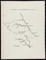
Des Barres, Joseph F. W. (Joseph Frederick Wallet), 1722-1824
Published / Created:
1775?-1781?]
Call Number:
1983 Folio 25
Image Count:
3
Resource Type:
Maps, Atlases & Globes
Abstract:
A made-up collection of charts, plans and views, partly hand colored, from the Atlantic Neptune comprising [v. 1]: the charts of the South East Coast of Nova Scotia, with the title page of The charts of the coast and harbors of New England, 1781 bound in front (31 items, dated between 1777 and 1781). [v. 2]: Charts of the coast and harbours in the Gulph and river of St. Lawrence, 1780, including the charts of the coast of New England (36 items, dated between 1775 and 1781). [v. 3]: Charts of several harbours and divers parts of the coast of North America from New York south westwards to the Gulph of Mexico, 1780, including some 16 charts belonging to the New England part of the work (35 items, dated between 1776 and 1781). General title page wanting.
Description:
Includes indexes.
Publisher:
The Admiralty,
Subject (Geographic):
North America--Maps and North America--Pictorial works