Search
You Searched For
Search Results
- Creator:
- Jefferys, Thomas, -1771
- Published / Created:
- 20 Feby., 1775.
- Call Number:
- 792cea 1775C
- Container / Volume:
- BRBL_00519
- Image Count:
- 1
- Resource Type:
- Maps, Atlases & Globes
- Found in:
- Beinecke Rare Book and Manuscript Library > The island of Cuba with part of the Bahama banks & the Martyrs / by Thos. Jefferys.
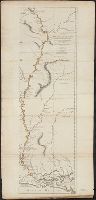
- Creator:
- Ross, Lieut
- Published / Created:
- 1 June 1775.
- Call Number:
- 807 1775
- Container / Volume:
- BRBL_00550
- Image Count:
- 1
- Resource Type:
- Maps, Atlases & Globes
- Found in:
- Beinecke Rare Book and Manuscript Library > Course of the river Mississippi from the Balise to Fort Chartres : taken on an expedition to the Illinois, in the latter end of the year 1765 / by Lieut. Ross of the 34th Regiment ; improved from the surveys of the river made by the French.
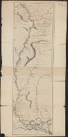
- Creator:
- Ross, Lieut
- Published / Created:
- 1 June 1775.
- Call Number:
- 807 1775A
- Container / Volume:
- BRBL_00550
- Image Count:
- 1
- Resource Type:
- Maps, Atlases & Globes
- Found in:
- Beinecke Rare Book and Manuscript Library > Course of the river Mississippi from the Balise to Fort Chartres : taken on an expedition to the Illinois, in the latter end of the year 1765 / by Lieut. Ross of the 34th Regiment ; improved from the surveys of the river made by the French.
- Creator:
- Kitchin, Thomas, d. 1784
- Published / Created:
- June 1st. 1789.
- Call Number:
- 755 1789
- Container / Volume:
- BRBL_00435
- Image Count:
- 1
- Resource Type:
- Maps, Atlases & Globes
- Found in:
- Beinecke Rare Book and Manuscript Library > North America, wherein are particularly distinguished the British dominions, the United States, and the adjacent Spanish territories / by Thomas Kitchin, hydrographer to His Majesty.
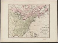
- Creator:
- Fry, Joshua, approximately 1700-1754
- Published / Created:
- 1794
- Call Number:
- 783 1794
- Container / Volume:
- BRBL_00507
- Image Count:
- 1
- Resource Type:
- Maps, Atlases & Globes
- Found in:
- Beinecke Rare Book and Manuscript Library > A map of the most inhabited part of Virginia containing the whole province of Maryland with part of Pensilvania, New Jersey and North Carolina / drawn by Joshua Fry & Peter Jefferson in 1775.
- Creator:
- Jefferys, Thomas, -1771
- Published / Created:
- 25 May, 1775.
- Call Number:
- BrSides Double Folio 2018 82
- Image Count:
- 1
- Resource Type:
- Maps, Atlases & Globes
- Found in:
- Beinecke Rare Book and Manuscript Library > An exact chart of the river St. Laurence : from Fort Frontenac to the island of Anticosti shewing the soundings, rocks, shoals &c. with views of the lands and all necessary instructions for navigating that river to Quebec / by ... Thos. Jefferys.
- Creator:
- Jefferys, Thomas, d. 1771
- Published / Created:
- 20 Feby. 1775.
- Call Number:
- 792cea 1775
- Container / Volume:
- BRBL_00519
- Image Count:
- 1
- Resource Type:
- Maps, Atlases & Globes
- Found in:
- Beinecke Rare Book and Manuscript Library > The coast of West Florida and Louisiana [cartographic material] : the Peninsula and Gulf of Florida or Channel of Bahama with the Bahama Islands / by Thos. Jefferys ...
- Creator:
- Jefferys, Thomas, d. 1771
- Published / Created:
- 25 May, 1775.
- Call Number:
- 7345cea 1775
- Container / Volume:
- BRBL_00689
- Image Count:
- 1
- Resource Type:
- Maps, Atlases & Globes
- Found in:
- Beinecke Rare Book and Manuscript Library > An exact chart of the river St. Laurence : from Fort Frontenac to the island of Anticosti shewing the soundings, rocks, shoals & c with views of the lands and all necessary instructions for navigating that river to Quebec / by ... Thos. Jefferys.
- Creator:
- Jefferys, Thomas, d. 1771
- Published / Created:
- 20, Feby. 1775.
- Call Number:
- 894 1775
- Container / Volume:
- BRBL_00697
- Image Count:
- 1
- Resource Type:
- Maps, Atlases & Globes
- Found in:
- Beinecke Rare Book and Manuscript Library > The Bay of Honduras [cartographic material] / by Thos. Jefferys, Geographer to His Majesty.