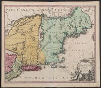
Cf. McCorkle, B.B. New England in early printed maps 1513-1800, no. 724.1., Map features New Jersey, New York and New England., Relief represented pictorially., and Sheet measures 51.5 x 60.4 cm.
Publisher:
[s.n.,
Subject (Geographic):
New England--Maps--Early works to 1800, New Jersey--Maps--Early works to 1800, and New York--Maps--Early works to 1800
Cf. McCorkle, B.B. New England in early printed maps 1513-1800, no. 724.1., Map features New Jersey, New York and New England., Relief represented pictorially., and Sheet measures 53.1 x 64.8 cm. Ms. no. on verso: 226. Cross Collection no. 182.
Publisher:
[s.n.,
Subject (Geographic):
New England--Maps--Early works to 1800, New Jersey--Maps--Early works to 1800, and New York--Maps--Early works to 1800
"Cum privilegio Sac. Caes. Maj.", Map features New Jersey, New York and New England., Relief represented pictorially., and Sheet measures 53.6 x 62.3 cm. Ms. no. on verso: 141. Title in ms. on verso. Franklin Collection no. 131 1759-2.
Publisher:
[s.n.,
Subject (Geographic):
New England--Maps--Early works to 1800, New Jersey--Maps--Early works to 1800, and New York--Maps--Early works to 1800
"Cum Privilegio Sac. Caes. Maj.", Inset in upper right margin shows continuation of Halland., Relief shown pictorially., and Watermark. Manuscript number in upper right corner. Manuscript waste pasted to verso. From the Karpinski-von Wieser Map Collection.
Publisher:
[Johann Baptist Homann]
Subject (Geographic):
Blekinge län (Sweden)--Maps--Early works to 1800., Hallands län (Sweden)--Maps--Early works to 1800., Skåne (Sweden)--Maps--Early works to 1800., Sweden--Blekinge län, Sweden--Hallands län, and Sweden--Ma
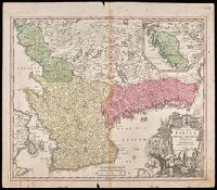
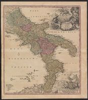
Novissima & exactissima totius regni Neapolis tabula, Novissima & exactissima totius regni Neapolis tabvla, Novissima and exactissima totius regni Neapolis tabula, and Novissima and exactissima totivs regni Neapolis tabvla
Description:
"Cum priv. S.C.M.", Bar scales given in "milliaria Germanica," "milliaria Gallica," and "milliaria Italica.", Copy 2: Ms. number on verso: XXXVIII. Sheet measures 61.9 x 54.4 cm., Includes legend and ill., and Relief shown pictorially.
Publisher:
Johann Baptist Homann,
Subject (Geographic):
Naples (Italy : Province)--Maps--Early works to 1800 and Naples (Kingdom)--Maps--Early works to 1800
[Atlas factice of 42 maps, produced by the Homann Erben firm]
Image Count:
2
Alternative Title:
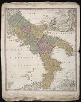
Novissima & exactissima totius regni Neapolis tabula, Novissima and exactissima totius regni Neapolis tabula, and Novissima and exactissima totivs regni Neapolis tabvla
Publisher:
Johann Baptist Homann
Subject (Geographic):
Naples (Italy : Province) --Maps --Early works to 1800 and Naples (Kingdom) --Maps --Early works to 1800