
You Searched For
« Previous
| 11 - 17 of 17 |
Next »
Search Results

- Creator:
- Teleki, Pál, gróf, 1879-1941
- Published / Created:
- 1919
- Call Number:
- 11hcf 1919-51
- Container / Volume:
- BRBL_00010L
- Image Count:
- 1
- Resource Type:
- Maps, Atlases & Globes
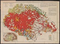
- Alternative Title:
- Carte ethnographique de la Hongrie construite en la accordance avec la densité de la population and Ethnographical map of Hungary based on the density of population
- Description:
- "Every square millimeter coloured indicates 100 inhabitants. According to the census of 1910.", Imperfect. text and leaf wanting. Copy 2 mounted on linen., In English, Hung, and Includes 1 inset map showing area around Budapest, sclae 1:5,000,000.
- Publisher:
- Hungarian Geographical Institut,
- Subject (Geographic):
- Carpathian Mountains Region--Maps, Czechoslovakia--Maps, Hungary--Maps, Romania--Romania--Transylvania--Maps, Yugoslavia--Maps, and Zakarpatsʹka oblastʹ (Ukraine)--Maps
- Subject (Topic):
- Ethnolo, Ethnology--Carpathian Mountains Region--Maps, Ethnology--Czechoslovakia--Maps, Ethnology--Hungary--Maps, Ethnology--Romania--Transylvania--Maps, and Ethnology--Ukraine--Zakarpatsʹka oblastʹ--Maps
- Found in:
- Beinecke Rare Book and Manuscript Library > Magyarország néprajzi térképe a népsürüség alapján = / szerkesztette Grof Teleki Pál = Ethnographical map of Hungary based on the density of population / by Count Paul Teleki = Carte ethnographique de la Hongrie construite en la accordance avec

- Creator:
- Teleki, Pál, gróf, 1879-1941
- Published / Created:
- 1919
- Call Number:
- 11hcf 1919-51
- Container / Volume:
- BRBL_00010L
- Image Count:
- 1
- Resource Type:
- Maps, Atlases & Globes
- Alternative Title:
- Carte ethnographique de la Hongrie construite en la accordance avec la densité de la population and Ethnographical map of Hungary based on the density of population
- Description:
- "Every square millimeter coloured indicates 100 inhabitants. According to the census of 1910.", Imperfect. text and leaf wanting., In English, Hungarian and French., and Includes 1 inset map showing area around Budapest, sclae 1:5,000,000.
- Publisher:
- Hungarian Geographical Institut,
- Subject (Geographic):
- Carpathian Mountains Region--Maps, Czechoslovakia--Maps, Hungary--Maps, Romania--Romania--Transylvania--Maps, Yugoslavia--Maps, and Zakarpatsʹka oblastʹ (Ukraine)--Maps
- Subject (Topic):
- Ethnolo, Ethnology--Carpathian Mountains Region--Maps, Ethnology--Czechoslovakia--Maps, Ethnology--Hungary--Maps, Ethnology--Romania--Transylvania--Maps, and Ethnology--Ukraine--Zakarpatsʹka oblastʹ--Maps
- Found in:
- Beinecke Rare Book and Manuscript Library > Magyarország néprajzi térképe a népsürüség alapján = / szerkesztette Grof Teleki Pál = Ethnographical map of Hungary based on the density of population / by Count Paul Teleki = Carte ethnographique de la Hongrie construite en la accordance avec
- Creator:
- Teleki, Pál, gróf, 1879-1941
- Published / Created:
- [1910?]
- Call Number:
- 43ed 1910
- Container / Volume:
- BRBL_00251
- Image Count:
- 1
- Resource Type:
- Maps, Atlases & Globes
- Alternative Title:
- Ethnographical map of Hungary based on the density of population
- Description:
- "Every square millimeter coloured indicates 100 inhabitants. According to the census of 1910.", Inset: Magyarország hegy- és vízrajzi térképe = Mountains and plains of the old Kingdom of Hungary., and Legend in English and Hungarian.
- Publisher:
- Hungarian Geographical Institut,
- Subject (Geographic):
- Carpathian Mountains--Maps, Czechoslovakia--Maps, Hungary--Census, 1910--Maps, Hungary--Maps, Romania--Transylvania--Maps, Yugoslavia--Maps, and Zakarpatsʹka oblastʹ (Ukraine)--Maps
- Subject (Topic):
- Ethnology--Carpathian Mountains Region--Maps, Ethnology--Czechoslovakia--Maps, Ethnology--Hungary--Maps, Ethnology--Romania--Transylvania--Maps, Ethnology--Slovakia--Maps, and Ethnology--Ukraine--Zakarpat
- Found in:
- Beinecke Rare Book and Manuscript Library > Magyarország néprajzi térképe a népsűrűség alapján = / szerkesztette Gróf Teleki Pál = Ethnographical map of Hungary based on the density of population / by Count Paul Teleki.

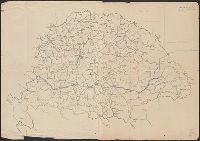
- Creator:
- Királyi Magyar Térképészeti Intézet
- Published / Created:
- [1918?-1943?]
- Call Number:
- 304 1886A
- Container / Volume:
- BRBL_00740
- Image Count:
- 9
- Resource Type:
- Maps, Atlases & Globes
- Description:
- BEIN Series 304 1886A: Imperfect: all sheets but C2-4, D2-4, E2-4 wanting., In upper margin of some maps: Domborzati áttekintés., Maps individually numbered and subtitled in upper margin, e.g.: B.4. Pola, Zara, Comacchio -- C2. Brno -- D.2. Kassa és Kraków -- E3. Koloszvár -- F.3. Bielcy, Kisziniew, Jassi., Publisher's name in lower margin differs: M. Kir. Térképészeti Intézet -- M. Kir. Állami Térképészeti Intézet -- M. Kir. Állami Térképészet -- M.kir. állami térképészet nyomása., Subtitles for the same map may differ according to ed., Title devised by cataloger., and Various eds. of some maps.
- Publisher:
- M. Kir. Térképészeti Intézet,
- Subject (Geographic):
- Europe, Eastern--Maps
- Found in:
- Beinecke Rare Book and Manuscript Library > [Kelet-Európa térképe] [cartographic material].
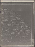
- Published / Created:
- 1919?]
- Call Number:
- 11hcf 1919C-4-1
- Container / Volume:
- BRBL_00010V
- Image Count:
- 1
- Resource Type:
- Maps, Atlases & Globes
- Description:
- Ms. notes in orange showing areas of "Czech occupation" and the "Roumanian Occupation", and a blue notes: "Line of the Treaty of Belgrade" and "Feb. 1, 1919."
- Publisher:
- s.n.,
- Subject (Geographic):
- Hungary--Maps
- Subject (Topic):
- Boundaries--Hungary--Maps
- Found in:
- Beinecke Rare Book and Manuscript Library > [Manuscript map of Hungary].
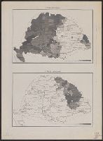
- Published / Created:
- 191-?]
- Call Number:
- 11hcf 1919D-18
- Container / Volume:
- BRBL_00010W
- Image Count:
- 2
- Resource Type:
- Maps, Atlases & Globes
- Description:
- 1. Romai katholikusok. -- 2. Görög katholikusok. -- 3. Görög keletiek. -- 4. Ag hitv. evangelikusok., Inferred title on sheet 2., and Maps show religious population in Hungary, by denomination.
- Publisher:
- s.n,
- Subject (Geographic):
- Hungary--Maps
- Found in:
- Beinecke Rare Book and Manuscript Library > [XII. A Népesség Hitfelekezet Szerint.]