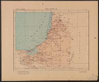
Mexico. Dirección de Estudios Geográficos y Climatológicos
Published / Created:
[1922]
Call Number:
8893 1922
Container / Volume:
BRBL_00656
Image Count:
2
Resource Type:
Maps, Atlases & Globes
Description:
"No. 4.", Accompanied by physiographic plate covering same area, showing only relief and drainage (1 sheet : col. ; 47 cm.)., and Relief shown by shading.
Publisher:
La Dirección,
Subject (Geographic):
Campeche (Mexico : State)--Maps
Subject (Name):
Mexico. Dirección de Estudios Geográficos y Climatológicos. Atlas geográfico de la República Mexicana
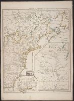
"Avec Privilege du Roi.", Insets: Map of territory west of Lake Superior; map of territory west of Florida; view of "Sault du Niagara, de 135 pieds de haut"., Relief shown pictorially., Second state: contains two keys to colors "Couleur selon les pretentions des Anglois" and "Selon les pretentions de la France.", and Watermark. Manuscript number on verso: XV 256.
Publisher:
[Georges-Louis Le Rouge] Rue des Augustins,
Subject (Geographic):
Atlantic States--Maps--Early works to 1800., France--Colonies--America--Maps--Early works to 1800., Great Britain--Colonies--America--Maps--Early works to 1800., Maritime Provinces--Maps--Early works to 1800., and United States--History--French and Indian War, 1754-1763--Maps--Early works to 1800.
1st state: Contains only 1 key to colors., 755 1755L: Hand col. Sheet measures 72.5 x 5, Insets: Map of territory west of Lake Superior; map of territory west of Florida; view of "Sault du Niagara, de 135 pieds de haut"., Relief shown pictorially., and Watermark.
Subject (Geographic):
Atlantic States--Maps--Early works to 1800, Great Britain--Colonies--America--Maps--Early works to 1800, Maritime Provinces--Maps--Early works to 1800, and United States--History--French and Indian War, 1755-1763--Maps--Early
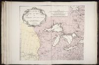
Anville, Jean Baptiste Bourguignon d', 1697-1782 Haye, G. de la
Published / Created:
Novembre 1755
Call Number:
2003 Folio 85
Image Count:
1
Description:
BEIN 2003 Folio 85: No. 3 of 45 maps bound together with binder's spine title: Atlas of America; ms. table of contents. Bookplate: Robinson. Bookplate of Paul Mellon., From the author's Atlas general. 1743-80., Hand colored., Has watermarks., National Maritime Museum. Catalog,, par le Sr. d'Anville ... ; [Gravee par] G. De-La-Haye., Relief shown pictorially., Scale [ca. 1:2,750,000]., and Sous le privilege de l'Academie.
Publisher:
Chez l'auteur, aux galeries du Louvre
Subject (Geographic):
Canada -- Maps -- Early works to 1800, Louisiana -- Maps -- Early works to 1800, and North America -- Maps -- Early works to 1800
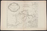
Anville, Jean Baptiste Bourguignon d', 1697-1782, cartographer
Published / Created:
Novembre MDCCLV [1755]
Call Number:
71 1755T
Container / Volume:
BRBL_00364
Image Count:
3
Resource Type:
Maps, Atlases & Globes
Description:
"Sous le privilége de l'Academie.", From Anville's Atlas général., Includes 5 bar scales., Prime meridian: Ferro., Relief shown pictorially., and Watermarks.
Publisher:
Chez l'auteur, aux galeries du Louvre, ‡c Novembre MDCCLV [1755]
Subject (Geographic):
Canada--Maps--Early works to 1800, Louisiana--Maps--Early works to 1800, and North America--Maps--Early works to 1800
Subject (Name):
Anville, Jean Baptiste Bourguignon d', 1697-1782. Atlas général and Haye, G. de la, engraver
From Aa's Nouvel Atlas ... A Leide : Chez Pierre Van der Aa ..., [1714], Mounted on paper. Sheet measures 29.8 x 36 cm. Cross Collection no. 165., and Relief shown pictorially.