Gouwen, Gilliam van der Visscher, Nicolaes, 1649-1702, creator
Published / Created:
[1690?]
Call Number:
1973 Folio 10
Image Count:
1
Resource Type:
Maps, Atlases & Globes
Alternative Title:
Landkaart vertonende het Graafschap Holland
Description:
Alternate title in upper margin: Landkaart vertonende het Graafschap Holland, seer dienstig om te reysen na : en van syne naburige provincien, als mede de Hoven van Soestdyk, 't Loo en Cleef / t' Amsteldam door Nicolaus Visscher met privilegie., Bar scales in Milliaria Germanica communia and Milliaria Gallica sive horae itineris., Ferro meridian., Includes col. ill. of figures in title cartouche., No. 44 of 69 maps bound together in composite atlas., Place-names in Dutch., Relief shown pictorially., and Scale [ca. 1:300 000].
Uytenbogaart, J. W. H. (Johannes Wilhelmus Huybert) Wit, Frederik de., creator
Published / Created:
[1680?]
Call Number:
1973 Folio 10
Image Count:
1
Resource Type:
Maps, Atlases & Globes
Description:
Appears in the Wit's Atlas from 1680., Dedication: Amplissimo Doctissimoque Viro Domino Do. Joanni Uytenbogaert Jcto. nomine Illustrium et praepotent. DD. ordinum Hollandiae et Westvrisiae Aerary Publici Amstelodamensis Tribuno., Includes color illustrated views of Messina, Catania, and Trapano, and ancillary maps of Milazzo and Palermo., No. 21 of 69 maps bound together in composite atlas., Oriented with north toward the upper left., Relief shown pictorially., Scale indeterminable., and Urbibus praecipuis exornatum et novissime editum per F. de Wit.
Publisher:
Gedruckt tot Amsterdam by Frederik de Wit inde Kalverstraet by den Dam inde Witte Paskaert
Ferro meridian., Gemeene Duytsche mylen van 15 in een graedt., No. 53 of 69 maps bound together in composite atlas., Relief shown pictorially., and Scale [ca 1:8 750 000].
Publisher:
By Frederick de Wit in de Kalversbraet in de Witte Pascaert
Descriptio ac delineatio geographica detectionis freti, sive, transitus ad occasum supra terras
Image Count:
1
Abstract:
Map depicts the Coat of Arms of the United Kingdom (era of the Union of the Crowns), reigning between the years 1603-1707.
Alternative Title:
Tabula nautica, qua repraesentantur orae maritimae, meatus, ac freta, noviter a H. Hudsono Anglo ad Caurum supra Novam Franciam
Description:
Bound in after p. [2]., In pencil on recto: 170., Map cut and folded irregularly., Map has multiple small stains on both the recto and verso., and Scale [ca. 1:9,000,000].
Charts and title pages in English, text in Dutch., Map oriented with North at bottom left., and Volvelle on p. [17].
Publisher:
Jodocus Hondius excudit,
Subject (Geographic):
Europe --Maps --Early works to 1800, Great Britain --Maps --Early works to 1800, Netherlands --Maps --Early works to 1800, and North Sea --Maps --Early works to 1800
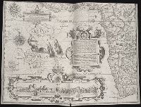
Nauigatio ac itinerarium Iohannis Hugonis Linscotani in Orientalem siue Lusitanorum Indiam
Image Count:
1
Description:
[Scale ca. 1:13,000,000]., Bound in following title page of "Descriptio totius Guineae tractus ...", In ink on top left panel of left verso: 3., and Map has several small tears now repaired on verso.
Subject (Geographic):
Africa, West --Maps --Early works to 1800
Subject (Name):
Claesz, Cornelis, ca. 1546-1609, publisher, Elzevier, Gillis, bookseller, and Hendricksz, Aelbrecht, fl. 1573-1605, printer
Subject (Topic):
Voyages and travels --Early works to 1800
Collection Created:
Hagae-Comitis : Ex officina Alberti Henrici, impensis authoris & Cornelii Nicolai, prostantque apud Aegidium Elseuirum, anno 1599
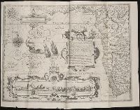
... Iohn Hvighen van Linschoten. his Discours of Voyages into ye Easte & West Indies. Deuided into
Image Count:
1
Abstract:
Engraved map depicts part of the south and west edge of Africa and also the islands of Ascension and Saint Helena within a special border.
Description:
[Scale ca. 1:13,000,000]., Bound in following title page of the second book., Map has been repaired with tape on verso., Map has black line on verso in center., Map has mirror image of brown marks on verso on bottom folded panels., and Map properly belongs to the Dutch edition of 1596.
Subject (Geographic):
Africa --Maps --Early works to 1800, Africa, West --Description and travel --Early works to 1800, Africa, West --Maps --Early works to 1800, Ascension Island (Atlantic Ocean) --Description and travel, and Saint Helena --Description and travel
Subject (Topic):
Voyages and travels --Early works to 1800
Collection Created:
Printed at London by Iohn Wolfe Printer to ye Honorable Cittie of London [1598]