

- None2
You Searched For
1 - 5 of 5
Search Results
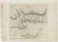
- Creator:
- Blaskowitz, Charles
- Published / Created:
- 1777.
- Call Number:
- 777.09.01.05++
- Image Count:
- 1
- Description:
- Relief shown by hachures., Appears in William Faden's Atlas of battles of the American Revolution. [1845], Oriented with north to the left., Indexed for points of interest., Available also through the Library of Congress Web site as a raster image., and Library copy annotated "12" in black ink at lower right.
- Subject (Geographic):
- Newport (R.I.)
- Found in:
- Lewis Walpole Library > A plan of the town of Newport in Rhode Island
3.

- Creator:
- Blaskowitz, Charles
- Published / Created:
- 1777.
- Call Number:
- Drawer 777.07.22.01+
- Image Count:
- 1
- Description:
- Relief shown by hachures. Depths shown by soundings and form lines., Inscribed "To the Right Honourable Hugh Earl Percy ... with His Lordship's permission ... by ... Wm. Faden.", and Includes text, "References to the batteries," and "A list of the principal farms in Rhode Island."
- Publisher:
- Engraved & printed for Wm. Faden
- Subject (Geographic):
- Narragansett Bay (R.I.), Rhode Island, and Narragansett Bay
- Subject (Topic):
- Nautical charts and Defenses
- Found in:
- Lewis Walpole Library > A topographical chart of the bay of Narraganset in the province of New England : with all the isles contained therein, among which Rhode Island and Connonicut have been particularly surveyed, shewing the true position & bearings of the banks, shoals, rocks &c. as likewise the soundings: To which have been added the several works & batteries raised by the Americans. Taken by order of the principal farmers on Rhode Island
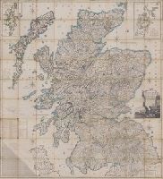
- Creator:
- Ainslie, John (Surveyor)
- Published / Created:
- [1800]
- Call Number:
- Folio 15 800Ai
- Image Count:
- 1
- Resource Type:
- cartographic image
- Alternative Title:
- Scotland drawn and engraved from a series of angles and astronomical observations
- Description:
- Title from cartouche., Engraved throughout., Relief shown by contour lines and pictures., Scale of miles 69 1/2 to a degree., Another imprint: "Published according to Act of Parliament Jan. 1st. 1789 by John Ainslie ... and William Faden ..." at bottom of sheet., Inset maps: "Shetland Islands laid down upon a less scale than the map ... "; "A Map of the Orkney Islands ...", Distance tables and lists of heights of hills and roads from Edinburgh to London., Edinburgh meridian, with note of degrees from Greenwich., Title cartouche shows men fishing and herding cattle, with sheep goats and foliage., Six compass roses., This issue not in Chubb, T. Printed maps in the atlases of Great Britain and Ireland., and Scotland.
- Publisher:
- Printed and sold by the proprietor Thomas Brown, North Bridge Street, Edinburgh and Publish'd according to Act of Parliament with improvements till 1800 by Thomas Brown ... Edinburgh and William Faden ... London
- Subject (Geographic):
- Scotland, Orkney (Scotland), Shetland (Scotland), Scotland., Orkney., and Shetland.
- Subject (Topic):
- Description and travel and Travel
- Found in:
- Lewis Walpole Library > Scotland : drawn and engrav'd from a series of angles and astronomical observations

- Creator:
- Ram, Johannes de, 1648-1693, printmaker
- Published / Created:
- [approximately 1690]
- Call Number:
- 724 690R
- Image Count:
- 59
- Resource Type:
- still image
- Abstract:
- Views of Rome (including the Vatican City), London, Amsterdam, and Tangier
- Description:
- All engraved. and Bound in full contemporary calf, spine gilt, red morocco label. For further information, consult library staff.
- Publisher:
- publisher not identified
- Subject (Geographic):
- London (England), Rome (Italy), Amsterdam (Netherlands), and Vatican City
- Found in:
- Lewis Walpole Library > Voornaamste gebouwen vande stadt Romen t'Amsterdam