Homann Erben (Firm) Homann, Johann Baptist, 1663-1724 Meyer, Tobias
Published / Created:
1749
Call Number:
1973 Folio 30
Collection Title:
[Atlas factice of 32 maps and 1 distance table, produced by the Homann Erben firm]
Image Count:
1
Alternative Title:
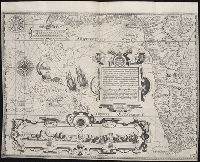
General map of Great Britain and Ireland with part of Holland Flandres France &c. agreable to modern history by the heirs of late Mr. Homann at Nueremburg 1749, priviledged by Emperours Majesty
Publisher:
Edentibg. Homan[n]ianis heredibus
Subject (Geographic):
Great Britain --Maps --Early works to 1800 and Ireland --Maps --Early works to 1800
Descriptio ac delineatio geographica detectionis freti, sive, transitus ad occasum supra terras
Image Count:
1
Abstract:
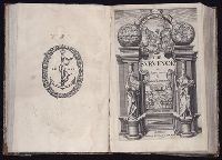
Map depicts the Coat of Arms of the United Kingdom (era of the Union of the Crowns), reigning between the years 1603-1707.
Alternative Title:
Tabula nautica, qua repraesentantur orae maritimae, meatus, ac freta, noviter a H. Hudsono Anglo ad Caurum supra Novam Franciam
Description:
Bound in after p. [2]., In pencil on recto: 170., Map cut and folded irregularly., Map has multiple small stains on both the recto and verso., and Scale [ca. 1:9,000,000].
Descriptio ac delineatio geographica detectionis freti, sive, transitus ad occasum supra terras
Image Count:
1
Abstract:
Map depicts the Coat of Arms of the United Kingdom (era of the Union of the Crowns), reigning between the years 1603-1707.
Alternative Title:
Tabula nautica ...
Description:
Bound in after p. [6]., In ink on recto: place names "Okkak", "Nain"[?] and one longer handwritten note on the bottom margin., Map cut and folded irregularly., Map has been repaired with multiple pieces of tape on verso., Map has multiple small stains on both the recto and verso., Printed on recto in lower right corner: A1., and Scale [ca. 1:9,000,000].
Subject (Geographic):
North Atlantic Ocean --Maps --Early works to 1800
Subject (Name):
Hudson, Henry, d. 1611
Collection Created:
Amsterodami Ex officina Hesse lij Gerardi. Anno 1613
Charts and title pages in English, text in Dutch., Map oriented with North at bottom left., and Volvelle on p. [17].
Publisher:
Jodocus Hondius excudit,
Subject (Geographic):
Europe --Maps --Early works to 1800, Great Britain --Maps --Early works to 1800, Netherlands --Maps --Early works to 1800, and North Sea --Maps --Early works to 1800
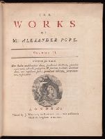
Errata on p. [1] at end., Made-up volume bound in 2 v. with groups r, s and t as per Griffith 372 (on thin paper; half-title (A2) of group r, on thick paper, bound in at front of 2:2), groups u (on thin paper) and v (on thick paper; quire C² on thin paper) as per Griffith 514, and groups s and u (on thick paper) as per Griffith 515., Signatures: A⁴ [superscript chi]B⁴ B-I⁴ K²(-K2) [superscript chi]K²(-K1) ²K2(K1+[superscript chi]A²), ²G-I⁴ ³[superscript chi]K²(-K1), ³B-C⁴ D² *F²(-*F2) F-K⁴, ⁴A-L⁴, ⁵A⁴ B⁴(-B4), ⁶B-2H⁴ [²[superscript chi]K1 signed K2]., The sheets of this edition were reissued, possibly in 1739, in a number of made-up copies in thick paper which include, in varying combinations, other separately published pieces by Pope up to 1738, (see Griffith, R.H. Pope, 514)., Title page in red and black., and With a half-title.
Publisher:
Printed by J. Wright, for Lawton Gilliver at Homer's Head in Fleetstreet,