According to Kershaw this map is the second state., From: The English pilot, the fourth book, published between 1732 and 1749., and Map is showing shoals and depth is shown by soundings.
Publisher:
Sold by Willm. Mount & Tho. Page at the Postern on Great Tower Hill,
Subject (Geographic):
Atlantic Coast (North America)--Maps--Early works to 1800
Subject (Name):
Mount, William, d. 1769, bookseller and Page, Thomas, d. 1733, bookseller
Subject (Topic):
Nautical charts--Atlantic Coast (North America)--Early works to 1800
Copper engraving, colored to show coasts of Eng., Decorative cartouche containing royal arms; on respective countries - coats of arms; compass rose - n. to right; Neptune carrying union jack in upper left; 2 ships, a whale., and Removed fr. the Atlas Maritimus.
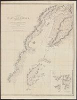
From: Vancouver's A voyage of discovery to the North Pacific Ocean and round the world. London, 1798., In top right margin: 5., Insets: Entrance of Columbia River -- Gray's Harbour -- Port Discovery., and Relief shown pictorially and by hachures. Depths shown by soundings.
Publisher:
J. Edwards & G. Robinson,
Subject (Geographic):
British Columbia--Maps--Early works to 1800 and Washington (State)--Maps--Early works to 1800
Subject (Name):
Arnold, Robert M.--Ownership, Baker, Joseph, 1768-1817, Edwards, James, 1757-1816, Robinson, G. G. (George G.), and Vancouver, George, 1757-1798. Voyage of discovery to the North Pacific Ocean and round the world. 1
Subject (Topic):
Coasts--British Columbia--Maps--Early works to 1800 and Coasts--Washington (State)--Maps--Early works to 1800
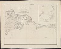
From: Vancouver's A voyage of discovery to the North Pacific Ocean and round the world. London, 1798., In top right margin: 7., Includes inset of "A survey of Port Stewart.", and Relief shown pictorially and by hachures. Depths shown by soundings.
Publisher:
J. Edwards & G. Robinson,
Subject (Geographic):
Alaska--Maps--Early works to 1800 and British Columbia--Maps--Early works to 1800
Subject (Name):
Arnold, Robert M.--Ownership, Baker, Joseph, 1768-1817, Edwards, James, 1757-1816, Robinson, G. G. (George G.), and Vancouver, George, 1757-1798. Voyage of discovery to the North Pacific Ocean and round the world. 1
Subject (Topic):
Coasts--Alaska--Early works to 1800 and Coasts--British Columbia--Maps--Early works to 1800
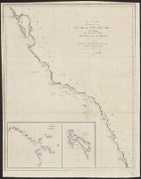
From: Vancouver's A voyage of discovery to the North Pacific Ocean and round the world. London, 1798., In top right margin: Plate 3., Includes inset of "Bay of Trinidad.", and Relief shown pictorially and by hachures. Depths shown by soundings.
Publisher:
J. Edwards & G. Robinson,
Subject (Geographic):
California--Maps--Early works to 1800 and Oregon--Maps--Early works to 1800
Subject (Name):
Arnold, Robert M.--Ownership, Baker, Benjamin, Baker, Joseph, 1768-1817, Edwards, James, 1757-1816, Robinson, G. G. (George G.), and Vancouver, George, 1757-1798. Voyage of discovery to the North Pacific
Subject (Topic):
Coasts--California--Maps--Early works to 1800 and Coasts--Oregon--Maps--Early works to 1800
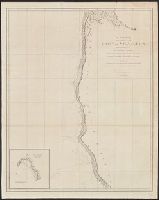
From: Vancouver's A voyage of discovery to the North Pacific Ocean and round the world. London, 1798., In top right margin: 14., and Relief shown pictorially and by hachures.
Publisher:
J. Edwards & G. Robinson,
Subject (Geographic):
Alaska--Maps--Early works to 1800 and Northwest Coast of North America--Maps--Early works to 1800
Subject (Name):
Arnold, Robert M.--Ownership, Edwards, James, 1757-1816, Roberts, Edward, Robinson, G. G. (George G.), and Vancouver, George, 1757-1798. Voyage of discovery to the North Pacific Ocean and round the world. 1798
From: Vancouver's A voyage of discovery to the North Pacific Ocean and round the world. London, 1798., In top right margin: No. 8., Insets: Entrance of Port Sn. Francisco -- Port Sn. Diego., and Relief shown pictorially and by hachures. Depths shown by soundings.
Publisher:
J. Edwards & G. Robinson,
Subject (Geographic):
California--Maps--Early works to 1800
Subject (Name):
Arnold, Robert M.--Ownership, Baker, Joseph, 1768-1817, Edwards, James, 1757-1816, Foot, T. (Thomas), Robinson, G. G. (George G.), and Vancouver, George, 1757-1798. Voyage of discovery to the North Pacifi
From: Vancouver's A voyage of discovery to the North Pacific Ocean and round the world. London, 1798., In top right margin: No. 11., Includes inset of "A survey of Port Chalmers.", and Relief shown pictorially and by hachures. Depths shown by soundings.
Publisher:
J. Edwards & G. Robinson,
Subject (Geographic):
Alaska--Map--Early works to 1800
Subject (Name):
Arnold, Robert M.--Ownership, Baker, Joseph, 1768-1817, Edwards, James, 1757-1816, Foot, T. (Thomas), Robinson, G. G. (George G.), and Vancouver, George, 1757-1798. Voyage of discovery to the North Pacifi
From: Vancouver's A voyage of discovery to the North Pacific Ocean and round the world. London, 1798., Includes inset of "A survey of Port Chatham.", and Relief shown pictorially and by hachures. Depths shown by soundings.
Publisher:
J. Edwards & G. Robinson,
Subject (Geographic):
Alaska--Maps--Early works to 1800
Subject (Name):
Arnold, Robert M.--Ownership, Baker, Joseph, 1768-1817, Edwards, James, 1757-1816, Neele, Samuel John, 1758-1824, Robinson, G. G. (George G.), and Vancouver, George, 1757-1798. Voyage of discovery to the
From: Vancouver's A voyage of discovery to the North Pacific Ocean and round the world. London, 1798., In top right margin: No. 12., Insets: Entrance into Cross Sound -- A survey of Port Conclusion -- A survey of Port Protection., and Relief shown pictorially and by hachures.
Publisher:
J. Edwards & G. Robinson,
Subject (Geographic):
Alaska--Maps--Early works to 1800
Subject (Name):
Arnold, Robert M.--Ownership, Baker, Joseph, 1768-1817, Edwards, James, 1757-1816, Foot, T. (Thomas), Robinson, G. G. (George G.), and Vancouver, George, 1757-1798. Voyage of discovery to the North Pacifi