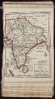
Vidal, A. T. E. (Alexander Thomas Emeric), 1792-1863, author
Call Number:
655 1827
Container / Volume:
BRBL_00345
Image Count:
1
Resource Type:
Maps, Atlases & Globes
Description:
Depths shown by isolines and soundings., Manuscript annotations on verso. Manuscript number in upper left corner: 666., Prime meridian: Greenwich., and Relief shown by hachures and spot heights.
Subject (Geographic):
Atlantic Coast (Africa)--Maps and South Atlantic Ocean--Navigation
Subject (Name):
Great Britain. Hydrographic Office, publisher, J. & C. Walker (Firm), engraver, Mudge, William, 1762-1820, and Owen, W. F. W., 1774-1857
Anville, Jean Baptiste Bourguignon d', 1697-1782 Compagnie des Indes Jefferys, Thomas, d. 1771, creator Kitchin, Thomas, d. 1784 Robert Laurie and James Whittle Sayer, Robert, 1725-1794
Published / Created:
1789 January 1
Call Number:
1982 Folio 10
Image Count:
1
Description:
Also appeared in Kitchin's General atlas describing the whole universe. London : Printed for Robert Sayer, [1780]., Has illustrated cartouche and includes text., No. 36 of 43 maps bound together in composite atlas., Norwich, O.I. Norwich's maps of Africa., Prime meridians: Ferro and London., Relief shown pictorially; depths by soundings., Scale [ca. 1:1,850,000]., and This map is copied from an original drawn by Monsr. D'Anville at the expense of the French East India Company, & published at Paris. The country thorough [sic] which the R. Senegal runs has been improved & corrected from a large & curious survey of that river found in the Fort of Senegal.
Publisher:
Printed for by Robert Sayer
Subject (Geographic):
Africa, West --Maps --Early works to 1800
Subject (Topic):
Coasts --Africa, West --Maps --Early works to 1800
"This map is copied from an original drawn by Monsr. D'Anville ... & published at Paris in 1751. But since the Peace of 1762, that map has been supressed [sic] ... ", Includes descriptive notes,, Prime meridians: Ferro and London., and Relief shown pictorially.
Publisher:
Printed for Robert Sayer in Fleet Street & Thomas Jefferys in the Strand,
Subject (Geographic):
Africa, West--Maps--Early works to 1800, Coasts--Africa, West--Maps--Early works to 1800, and Gambia--Colonization--Maps--Early works to 1800
Subject (Name):
Anville, Jean Baptiste Bourguignon d', 1697-1782 and Sayer, Robert, 1725-1794
"This map is copied from an original drawn by Monsr. D'Anv, Also appeared in Kitchin's General atlas describing the whole universe. London : Printed for Robert Sayer, [1780]., Prime meridians: Ferro and London., and Relief shown pictorially; depths by soundings.
Publisher:
Printed for Robert Sayer,
Subject (Geographic):
Africa, West--Maps--Early works to 1800
Subject (Name):
Abbot, Charles,--Baron Colchester,--1757-1829--Bookplate, Anville, Jean Baptiste Bourguignon d', 1697-1782, Kitchin, Thomas, d. 1784. General atlas describing the whole universe, and Robert Laurie and James Whittle
Imperfect: chipped., Insets: Canton River -- Van Diemen's Land -- Mouths of the River Hoogly -- Island and town of Singapore -- Colony of Good Hope., and Relief shown by hachures.
Subject (Name):
Copley, Charles, engraver, Karpinski, Louis Charles,--1878-1956--Ownership., Karpinski-von Wieser Map Collection., and Wieser, Franz,--Ritter von,--1848-1923--Ownership.
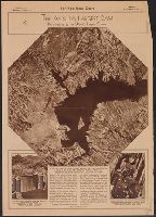
7 photos and text of international news on verso., Aerial photo from height of 20,000 ft. covering area of over 200 square miles., From The New York Times photogravure picture section, Sunday, September 1, 1935., and Includes text and photos of Hoover Dam and William Webber, cameraman.
Publisher:
New York Times,
Subject (Geographic):
Hoover Dam (Ariz. and Nev.)--Aerial views and Mead, Lake (Ariz. and Nev.)--Aerial views