Covers the area from Norfolk north to Lancaster Court House and west past Richmond and Petersburg., Shows fortifications, roads, railroads, towns, drainage, and vegetation., and This map varies from the one described by Library of Congress on OCLC Record #51294
Publisher:
United States Coast Survey,
Subject (Geographic):
Virginia--History--Civil War, 1861-1865--Maps and Virginia--Maps
"To accompany Report of Rear Admiral C. H. Davis, U.S.N., ordered by Resolution of the Senate of the United States of March 19, 1866., In right upper margin: No. V., Inset: Pr, and Shows proposed route of Panama Canal, railroads, roads, and existing settlements.
Publisher:
Govt. Printing Office,
Subject (Geographic):
Panama Canal (Panama)--Maps and Panama--Maps
Subject (Name):
Bowen & Co, Davis, Charles Henry, 1807-1877, Hergesheimer, E. (Edwin), and Panama Railroad Co.--Maps
United States. Army. Corps of Topographical Engineers
Published / Created:
1850 [i.e. 1851]
Call Number:
80 1850D
Container / Volume:
BRBL_00534
Image Count:
2
Resource Type:
Maps, Atlases & Globes
Description:
Date on map is 1850, however Wheat writes " ... ostensibly published in 1850, though it could not have gone to the engravers, Sherman and Smith of New York, until early in 1851" (Mapping the transmississippi West, 696)., On 2 sheets (each 62 x 105 cm.) and mounted on linen., and Relief shown by hachures.
United States. Congress. House. Report ; 23rd Congress, 1st session, 474.
Description:
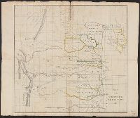
"This map prepared in the War Dept. by Lieut. Washington Hood"--Wheat, Mapping the transmississippi West, 405., Annotated on verso in ink., Covers lands in the Great Plains., From United States Congress, House Committee on Indian Affairs's Regulating the Indian Department. Washington, D.C.: Gales & Seaton, Print., 1834., In upper left: Rep. 474., Includes text about land that may be granted to the Cherokees., Prime meridian: Washington., Relief shown by hachures and pictorially., and Shows locations of Indian tribes.
Publisher:
Gales & Seaton, Print.,
Subject (Geographic):
Great Plains--Maps
Subject (Name):
Gales & Seaton and United States. Congress. House. Committee on Indian Affairs. Regulating the Indian Department
United States. Congress. House. Report ; 23rd Congress, 1st session, 474.
Description:
"This map prepared in the War Dept. by Lieut. Washington Hood"--Wheat, Mapping the transmississippi West, 405., Covers lands in the Great Plains., From United States Congress, House Committee on Indian Affairs's Regulating the Indian Department. Washington, D.C.: Gales & Seaton, Print., 1834., In upper left: Rep. 474., Includes text about land that may be granted to the Cherokees., Prime meridian: Washington., Relief shown by hachures and pictorially., and Shows locations of Indian tribes.
Publisher:
Gales & Seaton, Print.,
Subject (Geographic):
Great Plains--Maps
Subject (Name):
Gales & Seaton and United States. Congress. House. Committee on Indian Affairs. Regulating the Indian Department
United States. Army. Corps of Topographical Engineers
Published / Created:
1859
Call Number:
846 1859
Container / Volume:
BRBL_00620
Image Count:
1
Resource Type:
Maps, Atlases & Globes
Description:
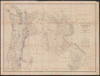
At head of title: Department of Oregon., Includes list of authorities and note., Relief shown by shading., and Shows Oregon, Washington, Idaho and Western Montana.
Publisher:
The Bureau],
Subject (Geographic):
Northwest, Pacific--Maps, Oregon--Maps, and Washington (State)--Maps
Subject (Name):
Dougal, William H., 1822-1895, Floyd, John B. (John Buchanan), 1806-1863, and United States. Army. Dept. of Oregon
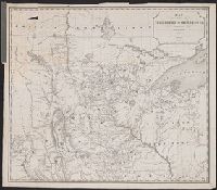
Includes "Note" and "Authorities.", Incorporates note and surveys added after Jan. 8, 1858., Relief shown by hachures and spot heights., and Shows Indian tribal locations, military posts, routes and dates of expeditions and surveys.
Publisher:
War Dept.,
Subject (Geographic):
West (U.S.)--Maps
Subject (Name):
Siebert, Selmar and United States. War Dept
Subject (Topic):
Pacific railroads--Explorations and surveys--Maps and Railroads--West (U.S.)--Maps
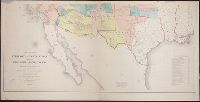
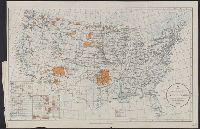
Insets: Mission Ind. res. in California. [Scale ca. 1:1,600,000] -- Indian pueblo grants in New Mexico. [Scale ca 1:2,300,000] -- Northeastern Oklahoma [Scale ca. 1:1,600,000]. and Map originally bound in: Annual report of the Department of the Interior.
Publisher:
Office of Indian Affairs],
Subject (Name):
Valentine, Robert G. (Robert Grosvenor), 1872-1916
Subject (Topic):
Indian reservations--United States--Maps and Indians of North America--Maps