
- None2
You Searched For
1 - 4 of 4
Search Results

1. England [art original]
- Creator:
- Hughes, J., active 1872, artist
- Published / Created:
- [30 March 1872]
- Call Number:
- Drawings H893 no. 1 Box D128
- Image Count:
- 1
- Resource Type:
- still image
- Abstract:
- A comic map of Great Britain: an old woman is shown in profile, facing to the left, and seated on the back of a dolphin-like monster. At the top her cap is Scotland; her neck is labeled R. Tees (River Tees) and along her back is "Humber" and "The Wash" The mouth of the creature is labeled "Thames". The other points on the map are: Isle of Wight and Bristol Channel, Cardogan Bay, and Anglesea (a bird perched on the woman's out-stretched hand).
- Alternative Title:
- Britannia
- Description:
- Title supplied by artist above design., Added title supplied by cataloger, based on the Gillray print of which this is a copy., Signed and dated by the artist in lower margin., and Drawn after James Gillray's print "Britannia", published 25 June 1791. Cf. No. 8045 in the Catalogue of prints and drawings in the British Museum. Division I, political and personal satires, v. 6.
- Subject (Geographic):
- England
- Found in:
- Lewis Walpole Library > England [art original]
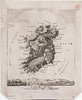
2. Geography bewitched!, or, A droll caricature map of Ireland [graphic].
- Creator:
- Dighton, Robert, 1752-1814, printmaker
- Published / Created:
- [1793]
- Call Number:
- 793.00.00.04
- Image Count:
- 1
- Resource Type:
- still image
- Alternative Title:
- Droll caricature map of Ireland
- Description:
- Title from item., Printmaker and publication date from British Museum catalogue., Two lines of text below title: This portrait of Lady Hibernia Bull ..., Temporary local subject terms: Comic maps -- Witch as a map -- Capes -- Harbors -- Emblems: Irish harp., and Text below title erased from this impression.
- Publisher:
- Printed for Bowles & Carver, No. 69 St Paul's Church Yard
- Subject (Geographic):
- Ireland
- Subject (Topic):
- Harps, Leprechauns, and Witches
- Found in:
- Lewis Walpole Library > Geography bewitched!, or, A droll caricature map of Ireland [graphic].

3. Voornaamste gebouwen vande stadt Romen t'Amsterdam
- Creator:
- Ram, Johannes de, 1648-1693, printmaker
- Published / Created:
- [approximately 1690]
- Call Number:
- 724 690R
- Image Count:
- 59
- Resource Type:
- still image
- Abstract:
- Views of Rome (including the Vatican City), London, Amsterdam, and Tangier
- Description:
- All engraved. and Bound in full contemporary calf, spine gilt, red morocco label. For further information, consult library staff.
- Publisher:
- publisher not identified
- Subject (Geographic):
- London (England), Rome (Italy), Amsterdam (Netherlands), and Vatican City
- Found in:
- Lewis Walpole Library > Voornaamste gebouwen vande stadt Romen t'Amsterdam
4. [Globe gores forgery after Martin Waldseemüller].
- Published / Created:
- [early 20th century]
- Call Number:
- GEN MSS 1486 (Oversize)
- Container / Volume:
- Box (Oversize)
- Image Count:
- 2
- Resource Type:
- still image
- Abstract:
- A photomechanical print probably created during the early twentieth century as a forgery that reproduces twelve gores for a globe published in 1507 by Martin Waldseemüller based on his wall map, Universalis Cosmographia (1507). and Evidence of the forgery includes the superimposition of the gores over glue already on the paper surface, which suggests use of a sheet removed from a period volume, as well as details that replicate gores from an authentic woodcut print formerly owned by Austrian cartographer Franz Hauslab and acquired by the James Ford Bell Library at the University of Minnesota in 1954
- Description:
- A gore is a roughly triangular or wedge-shaped segment of an object, as found in domes and globes, where a sector of a curved surface, or a curved surface that lies between two close lines of longitude on a globe, and flattened to a plane surface with little distortion., Martin Waldseemüller (1470-1519) was a German cartographer. His wall map Universalis Cosmographia (1507) and printed globes contemporarily derived from it were the first published globular maps of the Western Hemisphere and the first maps on which the name America appears in honor of Italian explorer Amerigo Vespucci (1454-1512)., In Latin., Title devised by cataloger., and Publication place and date of creation supplied by the cataloger.
- Subject (Geographic):
- America
- Subject (Name):
- Hauslab, Franz, 1798-1883., Vespucci, Amerigo, 1451-1512., and Waldseemüller, Martin, 1470-1519
- Subject (Topic):
- Forgeries, Globes, World maps, Discovery and exploration, and Name
- Found in:
- Beinecke Rare Book and Manuscript Library > [Globe gores forgery after Martin Waldseemüller].