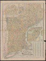
Map of New England showing state, county & township boundaries, railroads, post offices & distances
Description:
"Copyright 1897, by National Publishing Co.", Includes population of cities with over 2000 inhabitants., Insets: Map of Boston proper, Northern part of Maine, S.E. part of Maine., and Oriented with north toward the upper left.
Publisher:
National Pub. Co.,
Subject (Geographic):
New England--Maps
Subject (Topic):
Post Office Buildings--New England--Maps and Railroads--New England--Maps
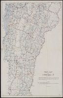
"Showing the State Roads, or Selected Highways, which are being improved by State aid and under state supervision in accordance with Chapters 193 and 194 General Laws. Revised by the State Highway Commissioner, Montpelier, Vt. Issued by Secretary of State, Publicity Department, Montpelier, Vt. 1917"