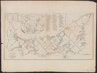
[Gulf of St. Laurence] -- The contents of the respective divisions of the island of St. John -- A list of lots and proprietors names., Depths shown by soundings., and Hand col. Sheet measures 55.2 x 73.8 cm. Cross Collection no. 172.
Publisher:
R. Sayer & J. Bennett?],
Subject (Geographic):
Prince Edward Island--Administrative and political divisions--Maps--Early works to 1800
Subject (Name):
Holland, Samuel, 1728-1801
Subject (Topic):
Real property--Prince Edward Island--Maps--Early works to 1800
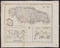
Draught of Port Royal or Kingston Harbour in Jamaica., Draught of the harbour of Port Antonio & St. Francis on the north east coast of Jamaica, and New and accurate map of the Island of Jamaica
Description:
From Bowen's Complete system of geography. London : Printed for William Innys, Richard Ware, Aaron Ward ..., 1747., London meridian., Scale given in English miles., Sheet measures 40.7 x 50.7 cm., and Shows boundaries, roads, forests, plantations and settlements.
Publisher:
s.n.,
Subject (Geographic):
Jamaica--Maps--Early works to 1800
Subject (Name):
Bowen, Emanuel, d. 1767. Complete system of geography
Subject (Topic):
Harbors--Jamaica--Kingston--Maps--Early works to 1800, Harbors--Jamaica--Port Antonio--Maps--Early works to 1800, and Harbors--Jamaica--Port Royal--Maps--Early works to 1800
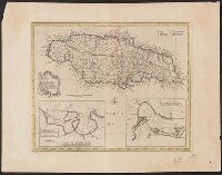
Draught of Port Royal or Kingston Harbour in Jamaica., Draught of the harbour of Port Antonio & St. Francis on the north east coast of Jamaica, and New and accurate map of the Island of Jamaica
Description:
"No. 66.", Cross Collection no. 283., From Bowen's Complete atlas ... London : Printed for William Innys and J, Hand col., London meridian., Scale given in English miles., and Shows boundaries, roads, forests, plantations and settlements.
Publisher:
s.n.,
Subject (Geographic):
Jamaica--Maps--Early works to 1800
Subject (Name):
Bowen, Emanuel, d. 1767. Complete atlas
Subject (Topic):
Harbors--Jamaica--Kingston--Maps--Early works to 1800, Harbors--Jamaica--Port Antonio--Maps--Early works to 1800, and Harbors--Jamaica--Port Royal--Maps--Early works to 1800
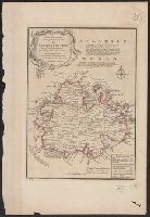
"No. 67" in lower left corner., Bar scale given in Enlgish miles., Cross Collection no. 295., From Bowen's A complete system of geography ... London : Printed for W. Innys, R. Ware ..., 1747., Has descriptive notes and ornamental cartouche., Imperfect: wormhole, with no loss of text. Hand col., and With paper tab pasted to left margin.
Publisher:
Printed for W. Innys, R. Ware ...,
Subject (Geographic):
Antigua--Maps--Early works to 1800
Subject (Name):
Bowen, Emanuel, d. 1767. A complete system of geography
Bar scale in miles., From The London magazine, or, Gentleman's monthly intelligencer. Oct. 1762, v. 21., Hand col. Mounted on linen. S, In upper margin: For the London magazine 1762., and Includes indexed inset of "A plan of the harbour & town of Havana" and ill.
Publisher:
Printed for R. Baldwin,
Subject (Geographic):
Cuba--Maps--Early works to 1800
Subject (Name):
Baldwin, R. (Robert), 1737-1810, bookseller
Subject (Topic):
Nautical charts--Caribbean Sea--Early works to 1800
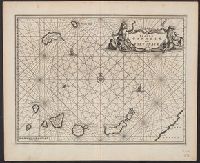
Ogilby, John, 1600-1676 Ogilby, John, 1600-1676. Africa, being an accurate description of the regions of Egypt, Barbary
Published / Created:
1670]
Call Number:
214 1670
Image Count:
1
Resource Type:
Maps, Atlases & Globes
Description:
Covers the Canary Islands and Madeira Islands., From Ogilby's Africa, being an accurate description of the regions of Egypt, Barbary, Lybia and Billedulgerid. 1, Has watermarks., Includes ill., rhumb lines, and decorative cartouche., and Relief shown pictorially.
Publisher:
Printed by T. Johnson for the author,
Subject (Geographic):
Canary Islands--Maps--Early works to 1800 and Madeira Islands--Maps--Early works to 1800
Subject (Topic):
Nautical charts--Canary Islands--Early works to 1800 and Nautical charts--Madeira Islands--Early works to 1800