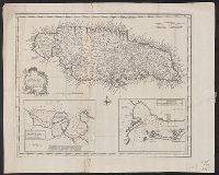
Draught of Port Royal or Kingston Harbour in Jamaica., Draught of the harbour of Port Antonio & St. Francis on the north east coast of Jamaica, and New and accurate map of the Island of Jamaica
Description:
From Bowen's Complete system of geography. London : Printed for William Innys, Richard Ware, Aaron Ward ..., 1747., London meridian., Scale given in English miles., Sheet measures 40.7 x 50.7 cm., and Shows boundaries, roads, forests, plantations and settlements.
Publisher:
s.n.,
Subject (Geographic):
Jamaica--Maps--Early works to 1800
Subject (Name):
Bowen, Emanuel, d. 1767. Complete system of geography
Subject (Topic):
Harbors--Jamaica--Kingston--Maps--Early works to 1800, Harbors--Jamaica--Port Antonio--Maps--Early works to 1800, and Harbors--Jamaica--Port Royal--Maps--Early works to 1800
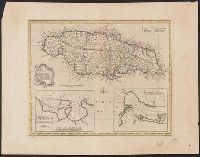
Draught of Port Royal or Kingston Harbour in Jamaica., Draught of the harbour of Port Antonio & St. Francis on the north east coast of Jamaica, and New and accurate map of the Island of Jamaica
Description:
"No. 66.", Cross Collection no. 283., From Bowen's Complete atlas ... London : Printed for William Innys and J, Hand col., London meridian., Scale given in English miles., and Shows boundaries, roads, forests, plantations and settlements.
Publisher:
s.n.,
Subject (Geographic):
Jamaica--Maps--Early works to 1800
Subject (Name):
Bowen, Emanuel, d. 1767. Complete atlas
Subject (Topic):
Harbors--Jamaica--Kingston--Maps--Early works to 1800, Harbors--Jamaica--Port Antonio--Maps--Early works to 1800, and Harbors--Jamaica--Port Royal--Maps--Early works to 1800