- Creator:
- United States. Army Map Service
- Published / Created:
- 1943
- Call Number:
- 533gm 1943
- Container / Volume:
- BRBL_00288
- Image Count:
- 1
- Resource Type:
- Maps, Atlases & Globes
- Alternative Title:
- [Its A.M.S. ; 5207] and Its. A.M.S. ; 5207.
- Description:
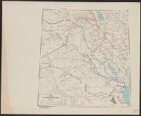
- "Lambert conformal conic projection.", Elevations are shown by hachures and spot heights in meters., Includes "Glossary.", Inset shows area with detailed transportation information., and Three classes of roads or trails and three classes of railroads are shown.
- Publisher:
- Army Map Service,
- Subject (Geographic):
- Iraq--Maps
- Subject (Topic):
- Transportation--Iraq--Maps
- Found in:
- Beinecke Rare Book and Manuscript Library > ʻIrāq [cartographic material] : special strategic map.
Search
Limit your search
- Public✖[remove]171
- cartographic171
- Maps✖[remove]171
- Cloth maps2
- Military maps1
- United States. Army Map Service✖[remove]171
- Great Britain. War Office. General Staff. Geographical Section9
- Manila Fire Insurance Association8
- U.S. Coast and Geodetic Survey3
- U.S. Lake Survey2
- United States. Aeronautical Chart Service2
- Geological Survey (U.S.)1
- Great Britain. War Office1
- United States. Army. Infantry Regiment, 17th1
- United States. Army. Philippine Scouts1
- Railroads--Soviet Union--Maps6
- Cities and towns--Korea (North)--Maps3
- Aeronautical charts--Japan2
- Cities and towns--Korea (South)--Maps2
- Transportation--Cyprus--Maps2
- Transportation--Finland--Maps2
- Transportation--Greece--Kyklades--Maps2
- Transportation--Sweden--Maps2
- Aeronautical charts--China1
- Transportation--Azores--Maps1
Current results range from 1941 to 1974