Homann Erben (Firm) L'Isle, Guillaume de, 1675-1726 Riccioli, Giovanni Battista, 1598-1671
Published / Created:
[1742?]
Call Number:
1975 Folio 31
Collection Title:
[Atlas factice of 42 maps, produced by the Homann Erben firm]
Image Count:
1
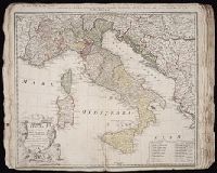
Alternative Title:
Gli stati d’Italia secondo le osservationi fatte dalla Societa di Se di Parigi, dal R.P. Riccioli della S. die Giesu ed. altri astronomi, di prima geograficamente delineati ... Sgr. de l’Isle ... alle spese degl’ heredi d’Homan[n] l’An[n]o MDCCXLII
Homann Erben (Firm) Homann, Johann Baptist, 1663-1724
Published / Created:
1729
Call Number:
1975 Folio 31
Collection Title:
[Atlas factice of 42 maps, produced by the Homann Erben firm]
Image Count:
1
Alternative Title:
General map of Great Britain and Ireland with part of Holland, Flanders France &c. agreable to modern history by the heirs of late Mr. Homann at Nuremburg, priviledged by Emperours Majesty
Publisher:
Homann Erben
Subject (Geographic):
Great Britain --Maps --Early works to 1800 and Ireland --Maps --Early works to 1800
[Atlas factice of 32 maps and 1 distance table, produced by the Homann Erben firm]
Image Count:
2
Alternative Title:
Carte des etats de la Covronne de Pologne
Publisher:
Luci publicae tradita per Homannianos Heredes
Subject (Geographic):
Belarus --Maps --Early works to 1800, Lithuania --Maps --Early works to 1800, Poland --Maps --Early works to 1800, and Ukraine --Maps --Early works to 1800
[Atlas factice of 42 maps, produced by the Homann Erben firm]
Image Count:
2
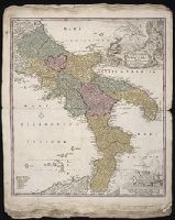
Alternative Title:
Novissima & exactissima totius regni Neapolis tabula, Novissima and exactissima totius regni Neapolis tabula, and Novissima and exactissima totivs regni Neapolis tabvla
Publisher:
Johann Baptist Homann
Subject (Geographic):
Naples (Italy : Province) --Maps --Early works to 1800 and Naples (Kingdom) --Maps --Early works to 1800
Hase, Johann Matthias, 1684-1742 Homann Erben (Firm) Lowitz, G. M. (George Moritz), 1722-1774
Published / Created:
1746
Call Number:
1975 Folio 31
Collection Title:
[Atlas factice of 42 maps, produced by the Homann Erben firm]
Image Count:
1
Alternative Title:
Mappe-monde qui represente les deux hemispheres savoir celui de l’orient et celui de l’occident, tiree des quatre cartes generales de feu M. le profess. Hasius, dressee par Mr. G.M. Lowitz et publiee par les Heritiers de Homann, avec privil. imper and Planiglobii terrestris mappa vniversalis
Publisher:
Homann Erben
Subject (Topic):
Atlases, German --Early works to 1800, Religion --Maps --Early works to 1800, and World maps --Early works to 1800
Hase, Johann Matthias, 1684-1742 Homann Erben (Firm) Lowitz, G. M. (George Moritz), 1722-1774
Published / Created:
1746
Call Number:
1973 Folio 30
Collection Title:
[Atlas factice of 32 maps and 1 distance table, produced by the Homann Erben firm]
Image Count:
1
Alternative Title:
Mappe-monde qui represente les deux hemispheres savoir celui de l’orient et celui de l’occident, tiree des quatre cartes generales de feu M. le profess. Hasius, dressee par Mr. G.M. Lowitz et publiee par les Heritiers de Homann and Planiglobii terrestris mappa vniversalis
Description:
Map colored to show distribution of religions.
Publisher:
[Homann Erben]
Subject (Topic):
Atlases, German --Early works to 1800, Religion --Maps --Early works to 1800, and World maps --Early works to 1800