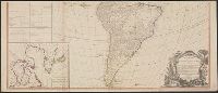
"Publish'd by Laurie & Whittle, No. 53 Fleet Street, as the Act directs, 12th May 1794.", Appears in Thomas Kitchin's General atlas, describing the whole universe., Copy 2: Joined into two sheets measuring 53.7 x 125.6 cm. and 53.7 x 125.6 cm. Stamped number on sheets: 34. Franklin Collection no. 131 1794 11-12., Includes table, "The Continent and Islands of America are Divided and Possessed as follows viz.", Inset: The supplement to North America containing the countries adjoining to Baffins & Hudson bays., Prime meridian: Ferro., Re-issue of John Gibson's map of [1763], 1772, 1777, 1783, and 1786., Relief shown pictorially., Shows the Western Hemisphere with some political borders, tabular information indicates national possessions; cities and rivers., and Title from ornamental cartouche.
Publisher:
Laurie & Whittle,
Subject (Geographic):
America--Maps--Early works to 1800 and West Indies--Maps--Early works to 1800
Subject (Name):
Gibson, J. (John), Kitchin, Thomas, d. 1784. General atlas describing the whole universe, Pownall, Thomas, 1722-1805, and Robert Laurie and James Whittle
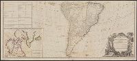
"Publish'd by Laurie & Whittle, No. 53 Fleet Street, as the Act directs, 12th May 1794.", Appears in Thomas Kitchin's General atlas, describing the whole universe., Copy 3: Joined into two sheets measuring 54.7 x 123.5 cm. and 54.6 x 123.4 cm. Stamped number on top sheet: 32. Stamped number on top sheet: 33. Franklin Collection no. 131 1794 13-14., Includes table, "The Continent and Islands of America are Divided and Possessed as follows viz.", Inset: The supplement to North America containing the countries adjoining to Baffins & Hudson bays., Prime meridian: Ferro., Re-issue of John Gibson's map of [1763], 1772, 1777, 1783, and 1786., Relief shown pictorially., Shows the Western Hemisphere with some political borders, tabular information indicates national possessions; cities and rivers., and Title from ornamental cartouche.
Publisher:
Laurie & Whittle,
Subject (Geographic):
America--Maps--Early works to 1800 and West Indies--Maps--Early works to 1800
Subject (Name):
Gibson, J. (John), Kitchin, Thomas, d. 1784. General atlas describing the whole universe, Pownall, Thomas, 1722-1805, and Robert Laurie and James Whittle
"To the Rt. Honble Anthony Earle of Shaftesbury Baron Ashley of Wimbourne St. Giles and Lord Cooper of Pawlet....", Has watermark., Includes decorative cartouche and ill., and Relief shown pictorially.
Copper engraved sea chart, colored by hand to show coasts of English counties and French providinces, Flanders, Holland, etc ... Loxodromes, direction of compass, shoals, soundings, coastal towns., Decorative title, dedicatory, and scal, and Preliminary record.
Bd. with before plate 37): his: The shape, skeleton and foliage of ... trees. [London, 1786]. In manuscript on half-title: "From the author". Uncut. Bound to 38 cm., Plates 17-36 (numbered 1-20) printed four to a plate., and Signatures: [A]-K2.
Publisher:
Printed for the author, by J. Dixwell, in St. Martin's Lane: and sold by Mr. A. Cozens, no. 4, Leicester Street, Leicester Fields; and J. Dodsley, in Pall Mall,