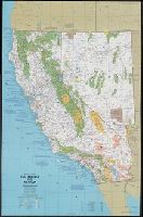
National Geographic Society (U.S.). Cartographic Division
Published / Created:
c1977.
Call Number:
7821 1977
Container / Volume:
BRBL_00506
Image Count:
2
Resource Type:
Maps, Atlases & Globes
Alternative Title:
Arizona, New Mexico, Utah, Colorado, Close-up: U.S.A., Arizona, New Mexico, Utah, Colorado, and Southwest
Description:
In upper right: Supplement to the National Geographic, October 1977, page 486A, vol. 152 no. 4-Close-up U.S.A., the Southwest., Includes list of abreviations., Relief shown by shading and spot heights., Shows points of interest., and Text and col. ill. on verso.
Publisher:
The Society,
Subject (Geographic):
Four Corners Region--Maps and Southwest, New--Maps
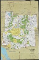
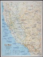
National Geographic Society (U.S.). Cartographic Division
Published / Created:
1984
Call Number:
80 1984
Container / Volume:
BRBL_00536
Image Count:
2
Resource Type:
Maps, Atlases & Globes
Description:
Ancillary maps on verso : 1. Spanish imprint, 1697-1823 -- 2. Sudden transition, 1821-1860 -- 3. The new Eden, 1860-1900 -- 4. Water, the key to growth, 1900-1940 -- 5. Explosive growth, 1940-present. Inset: and Folded title: The making of America, Far West.
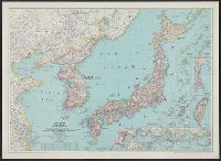
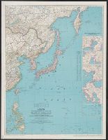
National Geographic Society (U.S.). Cartographic Division
Published / Created:
1945
Call Number:
57 1945
Container / Volume:
BRBL_00303
Image Count:
1
Resource Type:
Maps, Atlases & Globes
Description:
"Albers conical equal-area projection.", Copy 2 mounted on linen., Includes glossary of geographical terms., and Insets: 1-2. Kuril Islands.--3. Pescadores.--4. Karafuto.--5-7. Ryukyu Islands.--8. Formosa.--9. Tokyo.--10. Location of Japan in the Western Pacific
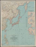
National Geographic Society (U.S.). Cartographic Division
Published / Created:
1945
Call Number:
57 1945
Container / Volume:
BRBL_00303
Image Count:
1
Resource Type:
Maps, Atlases & Globes
Description:
"Albers conical equal-area projection.", Includes glossary of g, Insets: 1-2. Kuril Islands.--3. Pescadores.--4. Karafuto.--5-7. Ryukyu Islands.--8. Formosa.--9. Tokyo.--10. Location of Japan in the Western Pacific., and Relief shown by shading and spot heights.
National Geographic Society (U.S.). Cartographic Division
Published / Created:
1944
Call Number:
556 1944A
Container / Volume:
BRBL_00293
Image Count:
1
Resource Type:
Maps, Atlases & Globes
Description:
"Azimuthal equidistant projection centered on Tokyo.", Insets: Industrial centers of Japan (5 maps)--Marshall Islands., Issued with the National geographic magazine, v. 85, no. 4, Apr. 1944., and Relief shown by hachures and spot heights.
National Geographic Society (U.S.). Cartographic Division
Published / Created:
1944
Call Number:
57 1944A
Container / Volume:
BRBL_00303
Image Count:
1
Resource Type:
Maps, Atlases & Globes
Description:
"Azimuthal equidistant projection centered on Tokyo.", Insets: Industrial centers of Japan (5 maps)--Marshall Islands., Issued with the National geographic magazine, v. 85, no. 4, Apr. 1944., and Relief shown by hachures and spot heights.
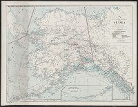
National Geographic Society (U.S.). Cartographic Division
Published / Created:
1914
Call Number:
848 1914D
Container / Volume:
BRBL_00631
Image Count:
1
Resource Type:
Maps, Atlases & Globes
Alternative Title:
National Geographic Magazine map of Alaska
Description:
"The Matthews-Northrup Works, Buffalo, N.Y.", At head of title: The National Geographic Magazine., Includes inset of "Western extension of Aleutian Islands" (scale l:7,500,000)., and Supplement to February, 1914 issue of The National Geographic Magazine.
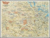
National Geographic Society (U.S.). Cartographic Division
Published / Created:
1986
Call Number:
8101 1986
Container / Volume:
BRBL_00552
Image Count:
2
Resource Type:
Maps, Atlases & Globes
Alternative Title:
Making of America ; no. 13
Description:
"Supplement to the National Geographic, December 1986, page 786A, vol. 170, no. 6.", Includes historical notes and key to abbreviations., Panel title: The making of America, Northern Plains., Relief shown by shading and spot heights., and Text, col. ill., and 5 m
Publisher:
The Society,
Subject (Geographic):
Great Plains--History--Maps, Great Plains--Maps, Middle West--History--Maps, and Middle West--Maps