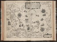
Tertia pars Indiae Orientalis ... / de Germanico in Latinum translata, & bono ordine disposita a
Image Count:
1
Description:
In pencil on verso: Part 3 p 132.
Subject (Geographic):
Arctic Ocean --Maps, Arctic regions --Discovery and exploration --Maps --Early works to 1800, Finland --Maps --Early works to 1800, Norway --Maps, and Sweden --Maps
Collection Created:
Francofurti : Excudebat Matthaeus Beckerus, anno MDCI [1601]
Manuscript on paper of Poggio Bracciolini, Dialogus in avariciam., The text has been glossed by a contemporary hand, in both Latin and German., and The text is the revised version made by Poggio following the suggestions of Niccolo Niccoli. The original version was printed in Basel (1538) and Strasbourg (1513), whereas the revised edition was never printed, although it exists in many manuscripts.
Description:
Binding: place uncertain, s. xx. Limp vellum case., Modern binder's blanks and contemporary blanks not scanned., On paper, and Written in elegant batarde by a single scribe.
Subject (Topic):
Avarice, Avarice--Early works to 1800, Dialogues, Latin (Medieval and modern), Manuscripts, Medieval--Connecticut--New Haven, and Medieval and Renaissance Manuscripts in Beinecke Library
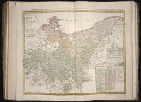
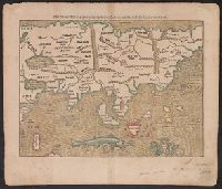
Laender Asie nach ihrer Gelegenheit biβ in Indiam, werden in dieser Tafeln verzeichnet
Description:
Appears in the author's Cosmographia., German, Latin., Hand col. Sheet measures 35 x 40 cm. Lanman Collection., Text, ill., "xxiiij" on verso., and Title on verso: India neuw.
Publisher:
H. Petri,
Subject (Geographic):
Asia--Maps--Early works to 1800
Subject (Name):
Münster, Sebastian, 1489-1552. Cosmographia and Petri, Heinrich, 1508-1579
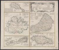
Cross Collection no. 245., Imperfect: map of Jamaica cut-out. Two maps (Antigua and Barbados)., Includes explanatory notes and index., Relief shown pictorially., Scales in millaria Anglica communia and/or millaria Anglica statuta., and Sheet title in Latin and German. Individual map titles and text in German. Maps in English and German.
Publisher:
Homann Erben,
Subject (Geographic):
Antigua--Maps--Early works to 1800, B, Barbados--Maps--Early works to 1800, Jamaica--Maps--Early works to 1800, Saint Kitts and Nevis--Maps--Early works to 1800, and West Indies--Maps--Early works to 1800
Cross Collection no. 253., Includes explanatory notes and index., Ms. notes in upper right corner., Relief shown pictorially., Scales in millaria Anglica communia and/or millaria Anglica statuta., Sheet title in Latin and German. Individual map titles and text in German. Maps in English and German., and Three maps (Antigua, Barbados, Jamaica). Mounted on linen.
Publisher:
Homann Erben,
Subject (Geographic):
Antigua--Maps--Early works to 1800, Barbados--Maps--Early works to 1800, Bermuda Islands--Maps--Early works to 1800, Jamaica--Maps--Early works to 1800, and Saint Kitts and Nevis--Maps--Early works to 1800