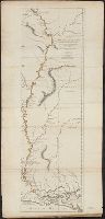
From Jefferys's The American atlas ... London : Printed and sold by R. Sayer and J. Bennett, 1776., Relief shown pictorially; depths by soundings., Sheets pasted together to form 1 sheet. Hand col. Sheets, and Shows forts, Indian villages, etc.
Publisher:
Printed for Robt. Sayer ...,
Subject (Geographic):
Mississippi River--Maps--Early works to 1800
Subject (Name):
Jefferys, Thomas, d. 1771. American atlas and Sayer, Robert, 1725-1794
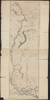
From Jefferys's The American atlas ... London : Printed and sold by R. Sayer and J. Bennett, 1776., Relief shown pictorially; depths by soundings., and Shows forts, Indian villages, etc.
Publisher:
Printed for Robt. Sayer ...,
Subject (Geographic):
Mississippi River--Maps--Early works to 1800
Subject (Name):
Jefferys, Thomas, d. 1771. American atlas and Sayer, Robert, 1725-1794
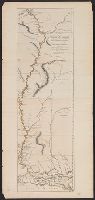
From Jefferys's The American atlas ... London : Printed and sold by R. Sayer and J. Bennett, 1776., Relief shown pictorially; depths by soundings., and Shows forts, Indian villages, etc.
Publisher:
Printed for Robt. Sayer ...,
Subject (Geographic):
Mississippi River--Maps--Early works to 1800
Subject (Name):
Jefferys, Thomas, d. 1771. American atlas and Sayer, Robert, 1725-1794
From Jefferys's The American atlas ... London : Printed, Relief shown pictorially; depths by soundings., and Sheets pasted together to form 1 sheet. Hand col. Sheets measure 62.5 x 55.3 cm. and 60.2 x 55.3 cm. Stamped no. on verso: 25. Cross Collection no. 225.
Publisher:
Printed for Robt. Sayer ...,
Subject (Geographic):
Mississippi River--Maps--Early works to 1800
Subject (Name):
Jefferys, Thomas, d. 1771. American atlas and Sayer, Robert, 1725-1794
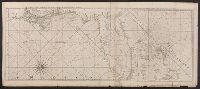
"B.F. 10" in upper right corner., Cross Collection no. 315., From Jefferys's American atlas. London : R. Sayer and J. Bennett, 1776., Prime meridians: Ferro and London., Relief shown pictorially; depths by soundings., and Stamped no. on verso: 26.
Publisher:
Printed for Robt. Sayer ...,
Subject (Geographic):
Central America--Maps--Early works to 1800, Honduras, Gulf of--Maps--Early works to 1800, and Mexico, Southeast--Maps--Early works to 1800
Subject (Name):
Jefferys, Thomas, d. 1771. American atlas and Sayer, Robert, 1725-1794
Subject (Topic):
Nautical charts--Honduras, Gulf of--Early works to 1800
Peninsula and Gulf of Florida or Channel of Bahama with the Bahama Islands
Description:
"DG.4.", From Jefferys's The American atlas ... London : Printed and sold by R. Sayer and J. Bennett, 1776., Hand colored., and Relief shown pictorially. Soundings shown in fathoms. "The soundings along the Florida coast, shoals, islands, and reefs are in feet."
Publisher:
Printed for Robt. Sayer, map and printseller ...,
Subject (Geographic):
Bahamas--Maps--Early works to 1800, Gulf Coast (Fla.)--Maps--Early works to 1800, and Gulf Coast (La.)--Maps--Early works to 1800
Subject (Name):
Jefferys, Thomas, d. 1771. American atlas and Sayer, Robert, 1725-1794
Peninsula and Gulf of Florida or Channel of Bahama with the Bahama Islands
Description:
"DG.4.", From Jefferys's The American atlas ... London : Printed and sold by R. Sayer and J. Bennett, 1776., Pictorial map, and Relief shown pictorially. Soundings shown in fathoms. "The soundings along the Florida coast, shoals, islands, and reefs are in feet."
Publisher:
Printed for Robt. Sayer, map and printseller ...,
Subject (Geographic):
Bahamas--Maps--Early works to 1800, Gulf Coast (Fla.)--Maps--Early works to 1800, and Gulf Coast (La.)--Maps--Early works to 1800
Subject (Name):
Jefferys, Thomas, d. 1771. American atlas and Sayer, Robert, 1725-1794
Peninsula and Gulf of Florida or Channel of Bahama with the Bahama Islands.
Description:
From Jefferys's The American atlas ... London : Printed and sold by R. Sayer and J. Bennett, 1776., Imperfect: detached along folds, with no loss of text. Sheets pasted together to form 1 sheet. Sheets measure 54 x 64 cm. and 54 x 66 cm., and Pictorial map.
Publisher:
Printed for Robt. Sayer, map and printseller ...,
Subject (Geographic):
Bahamas--Maps--Early works to 1800, Gulf Coast (Fla.)--Maps--Early works to 1800, and Gulf Coast (La.)--Maps--Early works to 1800
Subject (Name):
Jefferys, Thomas, d. 1771. American atlas and Sayer, Robert, 1725-1794