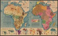
Eight inset maps (scale 1:110,000,000) show rainfall, exploration, drainage, population, races, German colonies, Islam., Physical geography -- Political complexion., Published in Fortune, Nov. 1941., and Relief shown by shading and spot heights.
Publisher:
Time, Inc.],
Subject (Geographic):
Africa--Maps
Subject (Topic):
Administrative and political divisions--Africa--Maps and Physical geography--Africa--Maps
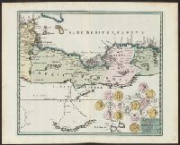
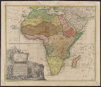
"Cum gratia et privil. S.R.I. Vicari atg., in partibg. Rheni, Suevice, et juris Franconici.", Has watermark., Includes ornamental cartouche and text., and Relief shown pictorially.
Great Britain. War Office. General Staff. Geographical Section
Published / Created:
1942
Call Number:
66gmb 1942
Container / Volume:
BRBL_00348
Image Count:
1
Resource Type:
Maps, Atlases & Globes
Alternative Title:
[G.S.G.S.] 4256 and GSGS (Series) ; 4256.
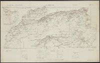
Description:
"Copied from a French (Michelin) map [sheet 151] dated 1939.", Includes index map and 3 insets: Région Meknès-Fes -- Région d'Oran -- Ré, Legend in French and English., and Shows roads, railroads, administrative boundaries, distances, and service facilities.
Publisher:
GSGS,
Subject (Geographic):
Africa, North--Maps
Subject (Name):
Pneu Michelin (Firm)
Subject (Topic):
Roads--Africa, North--Maps, Roads--Algeria--Maps, Roads--Morocco--Maps, and Roads--Tunisia--Maps
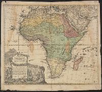
Cartouche lacks privilege., Includes text and ornamental cartouche with Africans, Europeans, flora, fauna, etc., Relief shown pictorially., and Sheet measures 52 x 60 cm. Ms. no. on recto: 58 [?].
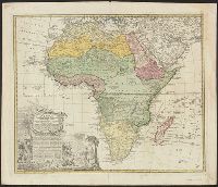
"Cum privil. S.C.M. nec non S.R.M. Polon. et Elect. Sax. A. 1737.", Includes text and ornamental cartouche with Africans, Europeans, flora, fauna, etc., Relief shown pictorially., and Sheet measures 52 x 62 cm.
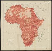
Issued with the Geographical Journal, 1911., Relief shown by spot heights., and Shows areas mapped from surveys, traverses, native reports or entirely unknown.