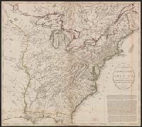
Particular map of Baffin and Hudson's Bay and Passage by land to California discover'd by Father Eusebius Francis Kino ...
Description:
"Longit. w. from Ferro.", Hand colored., Includes historical notes, notes on territorial claims, and insets of "A particular map of Baffin and Hudson's Bay" and "The passage by land to California.", and Relief shown pictorially.
Publisher:
Printed for Robert Sayer, no 53 Fleet Street ...,
Subject (Geographic):
North America--Maps--Early works to 1800
Subject (Name):
Gibson, J. (John), active 1750-1792 and Sayer, Robert, 1725-1794
2nd state. Distinguishing feature of 2nd state: "Title changed slightly to read 'An accurate map of the British Colonies...'" (McCorkle 111)., 755 1756F: Verso: Stamped "Oct 23 1959"., Printed text in left and right margins., and Published separately as broadsid
Publisher:
printed for and sold by H. Overton,
Subject (Geographic):
North America--Maps--Early works to 1800 and United States--History--French and Indian War, 1755-1763--Maps--Early works to 1800
Allen, Richard, Fellow of Pembroke College, Oxford
Published / Created:
1648
Call Number:
Mhc9 AL532 A7
Image Count:
85
Description:
Signatures: A-K8.
Publisher:
Printed by J. Macock, to be sold by Nathaniel Brooks,
Subject (Topic):
Anabaptists --Early works to 1800, Arminianism --Early works to 1800, Catholics --England --Early works to 1800, Christian sects --England --Early works to 1800, and Protestants --England --Early works to 1800
Bookplate of Frederick W. Williams., Large issue; v. 1-2 are 30 cm. tall, and v. 3 58 cm., P. 141-142 and p. 353-354 bound out of sequence., and The maps are on folded leaves.
Publisher:
Printed for G. Nicol, bookseller to His Majesty, Pall-Mall,
Subject (Geographic):
China--Description and travel, China--Foreign relations--Great Britain, and Great Britain--Foreign relations--China
Subject (Name):
Gower, Erasmus, Sir, 1742-1814, Macartney, George Macartney, Earl, 1737-1806, and Williams, Frederick Wells,--1857-1928--Bookplate
A view of the action gained by the English Sepr. 13 1759 near Quebec.
Description:
Insets: [1.] Part of the upper river of St. Laurence -- [2.] A view of the action gained by the English Sepr. 13, 1759, near Quebec, brought from thence by an officer of distinction., Oriented with north to upper right, and Relief shown by hachures and shading.
Publisher:
Published by Thos. Jefferys, Geographer to his Royal Highness the Prince of Wales, near Charing Cross,
Subject (Geographic):
Saint Lawrence River Estuary (Québec)--History, Military--Maps
Subject (Name):
Jefferys, Thomas, d. 1771 and Pitt, William, Earl of Chatham, 1708-1778, dedicatee
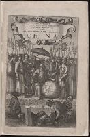
Embassy from the East India Company of the United Provinces to the Grand Tartar Cham, emperor of China. and Gezantschap der Neerlandtsche Oost-Indische Compagnie aan den grooten Tartarischen Cham, den tegenwoordigen Keizer van China. English
Description:
Added engraved t.p., Errors in paging: 185-204 omitted in numbering., and Imperfect: t.p. trimmed and mounted.
Publisher:
Printed by John Macock for the author,
Subject (Geographic):
China--Description and travel., China--History--Early works to 1800., and China--Politics and government--Early works to 1800.
Subject (Name):
Goyer, Pieter de., Keizer, Jacob de., Kircher, Athanasius, 1602-1680. China monumentis qua sacris qua profanis. English., Nederlandsche Oost-Indische Compagnie., Ogilby, John, 1600-1676., and Schall von Bell, Johann Adam, 1592?-1666.