
Search


Limit your search
- Public37
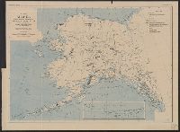
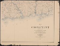
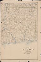
- Maps✖[remove]37
- Topographic maps3
- English37
- Geological Survey (U.S.)✖[remove]37
- Forests and forestry--Oregon--Coos County--Maps2
- Forests and forestry--Washington (State)--Chelan County--Maps2
- Forests and forestry--Washington (State)--King County--Maps2
- Forests and forestry--Washington (State)--Kittitas County--Maps2
- Forests and forestry--Wyoming--Big Horn County--Maps2
- Forests and forestry--Wyoming--Sheridan County--Maps2
- Land capability for agriculture--Oregon--Coos County--Maps2
- Land capability for agriculture--Wyoming--Big Horn County--Maps2
- Land use--Washington (State)--King County--Maps2
- Mines and mineral resources--Colorado--Leadville--Maps.2
- Geological Survey (U.S.). Annual report12
- Gannett, Henry, 1846-19149
- Plummer, Fred G. (Fred Gordon), 1864-19134
- Tweedy, Frank, 1854-19374
- Johnson, A. J3
- Julius Bien & Co3
- Barnard, E. C. (Edward Chester), 1863-19212
- Douglas, Edward Morehouse, 1855-19322
- Gannett, Samuel S. (Sameul Stinson), 1861-19392
- Geological Survey of New Jersey2
- [Washington, D.C.] :✖[remove]37
Current results range from 1880 to 1939