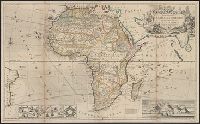
"According to the newest and most exact observations.", Includes views of "Cape Coast Castle on ye gold coast of Guinea," "James Fort on the island of St. Helena," and "A prospect of the Cape of Good Hope," and a plan of, and Prime meridians: London and Ferro.
Publisher:
Printed for H. Moll over against Devereux Court without Temple Bar, D. Midwinter at the 3 Crowns in St. Pauls church yard and Tho. Bowles print and mapseller next to the chapter house in St. Pauls church yard by Philip Overton, map and printseller near St
Subject (Geographic):
Africa--Maps--Early works to 1800
Subject (Name):
Bowles, Thomas, -1767, Midwinter, Daniel, active 1698-1725, and Overton, Philip, -1751
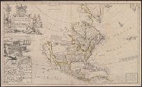
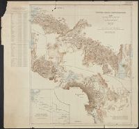
North America, according to ye newest and most exact observations
Description:
Appears in the author's The world described, or a new and correct sett of maps., Has watermark., Includes text, 10 insets of North American ports, decorative cartouche with coat of arms and figures, and "view of a stage & also, and Shows California as an island.
Publisher:
Printed for H. Moll, D. Midwinter at ye 3 Crowns in St. Pauls Church yard, T. Bowles ... next to the chapter house in St. Pauls Church yard, and over against Devereux Court, without Temple Bar, and by P. Overton ... near St. Dunstans Church Fleetstreet,
Subject (Geographic):
North America--Maps--Early works to 1800
Subject (Name):
Lens, Bernard, 1659-1725, Moll, Herman, d. 1732. World described, and Vertue, George, 1684-1756
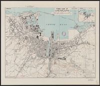
Great Britain. War Office. General Staff. Geographical Section
Published / Created:
1943
Call Number:
38 C42 1943
Container / Volume:
BRBL_00156
Image Count:
1
Resource Type:
Maps, Atlases & Globes
Alternative Title:
Geographical Section, General Staff ; no. 4234 and GSGS (Series) ; 4234.
Description:
"3rd edition 1943.", "Air photographs have been used in the production of this plan.", "Contours at 10 metres interval.", "N4937.4-W134.5/2.5x5.", "Published by War Office, 1941.", Important streets and buildings are named., and Includes inset map: Environs of Cher
Publisher:
[Printed by] Army Map Service, U.S. Army, and Published by War Office ;
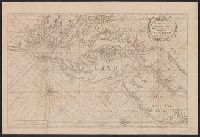
"Published under the superintendence of the Society for the Diffusion of Useful Knowledge.", Dissected and mounted on cloth. Folds to 9 x 10 cm. Ms. note on verso: Venice. dgvmp2008., and Insets: [1.] View of the Mint, St. Mark's Church, the Palace
Publisher:
Society for the Diffusion of Useful Knowledge,
Subject (Geographic):
Venice (Italy)--Maps
Subject (Name):
Davies, Benjamin Rees and Society for the Diffusion of Useful Knowledge (Great Britain)
Map of the country north and south of the Anglo German boundary reduced from the surveys of the British and German sections of the Commissions during the years 1904-1906
Description:
"Note. For information concerning the construction of this map, see the paper by Captain G.E. Smith, R.E., and the note by Captain T.T. Behrens, R.E., in the 'Geographical Journal' for March and July 1907.", "Section II.", and In upper right margin: Victoria Ny
Publisher:
Royal Geographical Society,
Subject (Geographic):
Kenya--Boundaries--Tanzania--Maps and Tanzania--Boundaries--Kenya--Maps
English pilot. Book 4. and Virginia, Maryland, Pennsylvania, east & west New Jersey
Description:
Appears in various eds. of The English pilot, Book 4., Depths shown by soundings., Mounted on linen. Sheet measures 59.1 x 87.2 cm. Cross Collection no. 191., Nautical chart of the coast from New York Bay to Chesapeake Bay,, and Oriented with north to the right.
Publisher:
Sold by William Mount & Tho. Page, Tower Hill,
Subject (Geographic):
Middle Atlantic States--Maps--Early works to 1800
Subject (Name):
Mount, William, d. 1769, bookseller and Page, Thomas, d. 1733, bookseller
Subject (Topic):
Coasts--Middle Atlantic States--Maps--Early works to 1800, Nautical charts--Atlantic Coast (Middle Atlantic States)--Early works to 1800, and Nautical charts--Middle Atlantic States--Early works to 1800
Great Britain. War Office. General Staff. Geographical Section
Published / Created:
1915
Call Number:
11hc 1915E
Image Count:
1
Resource Type:
Maps, Atlases & Globes
Alternative Title:
Geographical Section General Staff ; 3024 and GSGS (Series) ; 3024.
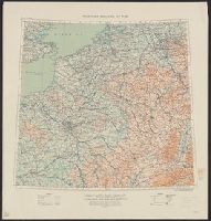
Description:
Ms. notes outside bottom right margin: "Based on Paris M31, Frankfurt M32, Lyons L31 & Milan L32, of Europe 1:1,000,000.", Relief shown as contours and gradient tints., and Shows: international boundaries, relative importance of towns, railways (2 categories),
Publisher:
G.S.G.S.,
Subject (Geographic):
Belgium--Maps and France--Maps
Subject (Topic):
World War, 1914-1918--Belgium--Maps and World War, 1914-1918--France--Maps
Coordinates not present on item and are approximated., Insets: Plan of Salesbury -- Image of Stone Henge -- 14 coats of arms of the "Earles of Wilshyre & Salesburye." Images of "The armes of the Earles of Wilshyre & Salesburye ..." appear in the lower left of the map., On verso: English text with running-title "Book I. Wilt-Shire. Chap. 14", Signature "R", p. 25 and 26., Originally issued ca. 1610 and appeared in: Theatre of the Empire of Great Britaine. London, Sudbury & Humble, 1614 (i.e. 1616)., and Relief shown pictorially.
Publisher:
Performed by Iohn Speed and are to be sold in Popes head alley against the Exchange by Iohn Sudbury and G. Humble, cum privilegio,
Subject (Geographic):
Salisbury (England)--Maps--Early works to 1800, Stonehenge (England)--Maps--Early works to 1800, and Wiltshire (England)--Maps--Early works to 1800
Subject (Name):
Humble, George, -1640, Speed, John, 1552?-1629. Theatre of the Empire of Great Britaine, and Sudbury, John
From the Atlantic Neptune, Vol.3, ,,, the coast and harbours of New England ... From the surveys ... by Samuel Holland, Esq. Part II. Plate "9". and Stipple engraved sailing chart, land col. pale brown by hand, modified for individual holdings, cities red. Hi