Skip to search
Skip to main content
Skip to first result
Search
You Searched For
Format
cartographic
New Search
Search Results
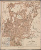
Creator:
Published / Created:
1908
Call Number:
5631 1908
Container / Volume:
BRBL_00299
Image Count:
1
Resource Type:
Maps, Atlases & Globes
Alternative Title:
Geographical Section General Staff ; no. 2112 and GSGS (Series) ; 2112.
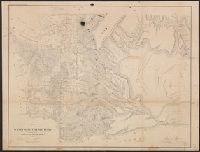
Description:
"War Office, April 1906. Corrected to Dec. 1908.", Includes explanations and conventional signs., Includes inset: sketch map of China (Scale 1:20,000,000)., and Relief shown by spot heights and shading.
Publisher:
War Office,
Subject (Geographic):
Yunnan Sheng (China)--Maps
Found in:
Beinecke Rare Book and Manuscript Library > Map of Yün-nan / compiled by Major H.R. Davies.
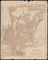
Creator:
Published / Created:
1908
Call Number:
5631 1908
Container / Volume:
BRBL_00299
Image Count:
1
Resource Type:
Maps, Atlases & Globes
Alternative Title:
Geographical Section General Staff ; no. 2112 and GSGS (Series) ; 2112.
Description:
"War Office, April 1906. Corrected to Dec. 1908.", Includes explanations and conventional signs., Includes inset: sketch map of China (Scale 1:20,000,000)., and Relief shown by spot heights and shading.
Publisher:
War Office,
Subject (Geographic):
Yunnan Sheng (China)--Maps
Found in:
Beinecke Rare Book and Manuscript Library > Map of Yün-nan / compiled by Major H.R. Davies.
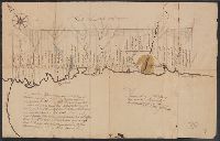
Published / Created:
1762
Call Number:
771fcm M726 1762
Container / Volume:
BRBL_00714
Image Count:
2
Resource Type:
Maps, Atlases & Globes
Description:
"Surveyed at the request of Oliver Delancey Peter Remsen and performed by me, Chris: Yates, Schonectady, Nov. 9, 1762." and Color: pen and ink.
Subject (Geographic):
New York--Maps, Manuscript--Early works to 1800
Found in:
Beinecke Rare Book and Manuscript Library > Map of a certain track of Land lying & being on the North Side of the Mohowk River ...
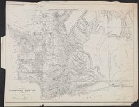
Published / Created:
1863
Call Number:
783hc 1863S
Container / Volume:
BRBL_00512
Image Count:
3
Resource Type:
Maps, Atlases & Globes
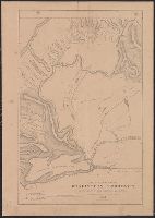
Description:
"Prepared at the Hd Qurs Army of Potomac April 10, 1863, G.K. Warren Brig Genl vols." and Sheet 2 (NE quadrant of map) missing.
Publisher:
Corps of Topographical Engineers],
Subject (Geographic):
Virginia--History--Civil War, 1861-1865--Maps
Subject (Name):
Mallory, C. A, Paine, William H, United States. Army. Corps of Topographical Engineers, Walker, L. E, and Warren, Gouverneur Kemble, 1830-1882
Found in:
Beinecke Rare Book and Manuscript Library > Map of a part of Eastern Virginia : including portions of Spotsylvania Co. and adjoining counties / compiled by Capt. W.H. Paine, A.D.C.
Creator:
Published / Created:
1860
Call Number:
847 1861
Container / Volume:
BRBL_00625
Image Count:
1
Resource Type:
Maps, Atlases & Globes
Alternative Title:
Sen. ex. doc. ; no. 1, 2nd session, 36th Congress and Senate executive document (United States. Congress. Senate) ; 36th Congress, 2nd session, no. 1.
Description:
Relief shown by hachures. and Signed: "James Tilton...," Surveyor General's Office, Olympia, W.T, Sept. 20th, 1860.
Publisher:
s.n.],
Subject (Geographic):
Washington (State)--Maps
Subject (Name):
Bien, Julius, 1826-1909 and Tilton, James
Found in:
Beinecke Rare Book and Manuscript Library > Map of a part of Washington Territory : to accompany the report of the Surveyor General, 1860-61.
Creator:
Published / Created:
1859
Call Number:
847 1859A
Container / Volume:
BRBL_00625
Image Count:
1
Resource Type:
Maps, Atlases & Globes
Alternative Title:
Senate executive document (United States. Congress. Senate) ; 36th Congress, 1st session, no. 2.
Description:
"Sen. Ex. Doc. No. 2, 1st session 36th Congress.", Relief shown by hachures., Shows surveys, reservations and trails., and Signed by Surveyor General.
Publisher:
Surveyor General's Office?],
Subject (Geographic):
Washington (State)--Maps
Subject (Name):
Bien, Julius, 1826-1909
Found in:
Beinecke Rare Book and Manuscript Library > Map of a part of Washington Territory : to accompany the report of the Surveyor General.
Creator:
Published / Created:
1857
Call Number:
847 1857
Container / Volume:
BRBL_00625
Image Count:
1
Resource Type:
Maps, Atlases & Globes
Description:
"Surveyor General's Office, Olympia, W.T., September 21st 1857. James Tilton [signature], Surveyor General.", From Congressional serial set 1857., Relief shown by hachures., and Shows Columbia River, "Great Plateau of Spokane," "Steven's route Pacific R.R.," forts, and "Military road from Steilacoom to Walla-Walla."
Publisher:
General Land Office?],
Subject (Geographic):
Washington (State)--Maps
Subject (Name):
Graham, C. B. (Curtis B.) and Washington (State). Surveyor General's Office
Found in:
Beinecke Rare Book and Manuscript Library > Map of a part of Washington Territory lying east of the Cascade Mountains : to accompany report of Surveyor General.
Published / Created:
1862
Call Number:
783 R182 1862
Container / Volume:
BRBL_00510
Image Count:
1
Resource Type:
Maps, Atlases & Globes
Description:
Manuscript note "No. 158" in upper right corner.
Publisher:
Office of Surveys & Maps for the Army of the Potomac,
Subject (Geographic):
Fredericksburg (Virginia)--Maps
Found in:
Beinecke Rare Book and Manuscript Library > Map of a part of the Rappahannock River : Above Fredericksburg and of the Rapid Ann River & the adjacent country / Compiled under the direction of Col. J.N. Macomb, A.D.C. Topl. Engr. by Capt. W.H. Paine.
Creator:
Published / Created:
1855
Call Number:
847 1855A
Container / Volume:
BRBL_00625
Image Count:
1
Resource Type:
Maps, Atlases & Globes
Alternative Title:
Sen. ex. doc. ; no. 1, 1st session, 34th Congress and Senate executive document (United States. Congress. Senate) ; 34th Congress, 1st session, no. 1.
Description:
"James Tilton, Surveyor General.", Relief shown by hachures., and SML 2013 D51 copy: From Congressional serial set 1855.
Publisher:
Surveyor General's Office,
Subject (Geographic):
Washington (State)--Maps
Subject (Name):
Tilton, James
Found in:
Beinecke Rare Book and Manuscript Library > Map of a part of the territory of Washington : to accompany report of Surveyor General, 1855.
Published / Created:
[1859?] and [between 1880 and 1889?]
Call Number:
BrSides Folio 2018 138
Image Count:
1
Resource Type:
Maps, Atlases & Globes
Alternative Title:
Map of a portion of Point Keweenaw, Lake Superior
Description:
Backed with linen. Manuscript annotations on map. Manuscript title on verso: Copper Harbour & Eagle Harbour. From the Richard H. Rickard Papers. and In upper left corner: 59.
Publisher:
[publisher not identified],
Subject (Geographic):
Keweenaw County (Mich.)--Maps. and Michigan--Keweenaw County
Subject (Name):
Delaware Mining Company of Michigan--Maps., Friend, Norman M., approximately 1815-, Pennsylvania Mining Company of Michigan--Maps., and Rickard, Richard H.,---1885--Ownership.
Subject (Topic):
Copper mines and mining, Copper mines and mining--Michigan--Keweenaw County--Maps., Landowners, Landowners--Michigan--Keweenaw County--Maps., Mines and mineral resources, and Mines and mineral resources--
Found in:
Beinecke Rare Book and Manuscript Library > Map of a portion of Point Keweenaw, L.S. : showing the lands &c. of the Pennsylvania & Delaware Mining Co's.
Branch:v1.61.6 ,Deployed:2024-06-12T09:55:33-04:00