Charts and title pages in English, text in Dutch., Map oriented with North at bottom left., and Volvelle on p. [17].
Publisher:
Jodocus Hondius excudit,
Subject (Geographic):
Europe --Maps --Early works to 1800, Great Britain --Maps --Early works to 1800, Netherlands --Maps --Early works to 1800, and North Sea --Maps --Early works to 1800
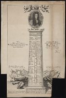
The frontispiece is dated 1795 and is included in the Contents list., Frontispiece of William Hogarth, 2 leaves (letterpress title page and "A catalogue of the original works of William Hogarth contained in this volume"), and 110 engravings on 85 leaves., and Bound in full contemporary calf, spine richly gilt in compartments, red morocco lettering piece, rebacked. For further information, consult library staff.
Publisher:
Sold by John and Josiah Boydell, at the Shakespeare Gallery, Pall-Mall, and No. 90, Cheapside, London
Subject (Geographic):
England and England.
Subject (Name):
Hogarth, William, 1697-1764. and Hogarth, William, 1697-1764
Subject (Topic):
English wit and humor, Pictorial, Social life and customs, and Manners and customs
Stamp of the American Antiquarian Society; autograph of Stephen Salisbury, jr.; imperfect: 1 leave of plates wanting. Includes (p. [17]-20): The butterfly's ball and the grasshopper's feast by William Roscoe.
Publisher:
Published by David Longworth at the Dramatic Repos
Principal islands in America belonging to the English empire viz Jamaica, Barbados, Antegoa, St. Christophers & Bermudos
Description:
[Antigua and Bermuda Islands] -- A general map of the Cariby Islands -- [Saint Kitts] -- [Barbados] -- The explanation of the marks on the island of Iamaica., Bar scale given in miles., No. 62 of 69 maps bound together in composite atlas., Relief shown pictorially., and Scales differ.
Publisher:
Sold by Phillip Lea at the Atlas and Hercules in Cheapside
Dominions of Turky in Europe in which are the governments of Romelia of the sea, of Buda, of Teme's war, and of Bosnia ... described by Sanson, corrected and amended by William Berry
Description:
Bar scales in Italian miles, common leagues of France, common leagues of Germany or great leagues of Poland, leagues of Hungary, and leagues that are of one hours travelling., Dedicated To the most serene and most sacred majesty Charles II ... by William Berry., No. 24 of 69 maps bound together in composite atlas., Relief shown pictorially., and Scale [ca. 1:3 500 000].
Publisher:
Sold by William Berry at the signe of the Globe between Charing-Cross and White-Hall
Subject (Geographic):
Balkan Peninsula --Maps --Early works to 1800, Italy --Maps --Early works to 1800, and Turkey --Maps --Early works to 1800