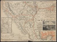
Santa Fé route : and Santa Fé route to the city of Mexico by the Atchison, Topeka and Santa Fé R.R. and Mexican Central R.R.
Description:
"February" on panel and "November 29, 1885" on timetable., Covers southweste, Relief shown by hachures., Shows cities and towns, stations, Indian reservations, state boundaries, and the railroad network emphasizing the main line., and Text and timetable on verso.
Publisher:
Rand, McNally,
Subject (Name):
Atchison, Topeka, and Santa Fe Railroad Company, Atchison, Topeka, and Santa Fe Railroad Company--Maps, Mexican Central Railway Co, and Mexican Central Railway Co.--Maps
Subject (Topic):
Railroads--Mexico--Maps, Railroads--Mexico--Timetables, Railroads--Southwestern States--Maps, and Railroads--Southwestern States--Timetables
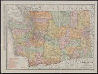
Rand McNally & Co.'s new business atlas map of Washington.
Description:
Below scale: Rand McNally & Co.'s new business atlas map of Washington. Copyright 1911 by Rand McNally & Co. Copyright 1905 by Rand McNally & Co., Indexed., Railroads shown in red., and Relief shown by hachures and spot heights.