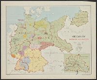
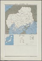
United States. Department of State. Division of Map Intelligence and Cartography
Published / Created:
1947
Call Number:
57134 1947A
Container / Volume:
BRBL_00308
Image Count:
1
Resource Type:
Maps, Atlases & Globes
Description:
"10077 February 1947.", Base from AMS L571, 1st ed., 1943, 1:250,000., Boundaries and center of population revised to Nov. 1943., and Includes ancillary map, glossary, and list of counties.
Publisher:
Dept. of State, Division of Map Intelligence and Cartography/CAHSA,
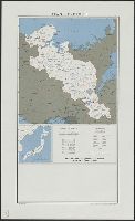
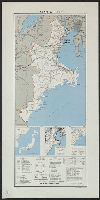
United States. Department of State. Division of Map Intelligence and Cartography
Published / Created:
[1946]
Call Number:
57144 1946
Container / Volume:
BRBL_00309
Image Count:
1
Resource Type:
Maps, Atlases & Globes
Description:
"10065 November 1946.", Base from A.M.S. L571, 1st ed., 1943, 1:250,000., Boundaries and centers of population revised to Nov. 1943., and Includes centers of population, list of gun, and location map of Japan.
Publisher:
Reproduction Branch, OSS,
Subject (Geographic):
Okayama-ken (Japan)--Maps
Subject (Name):
United States. Office of Strategic Services. Reproduction Branch
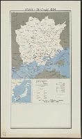
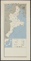
United States. Department of State. Division of Map Intelligence and Cartography
Published / Created:
[1946?]
Call Number:
5711 1946A
Container / Volume:
BRBL_00308
Image Count:
1
Resource Type:
Maps, Atlases & Globes
Description:
"10058 July 1946.", Base from A.M.S. L571, first edition, 1943 1:250,000; boundaries and centers of population revised to November 1943., and Includes ancillary map, glossary, and list of counties.
Publisher:
Dept. of State, Division of Map Intelligence and Cartography/CAHSA,
Subject (Geographic):
Aichi-ken (Japan)--Administrative and political divisions--Maps
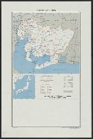
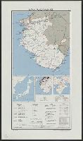
United States. Department of State. Division of Map Intelligence and Cartography
Published / Created:
[1946?]
Call Number:
57122 1946
Container / Volume:
BRBL_00308
Image Count:
1
Resource Type:
Maps, Atlases & Globes
Description:
"10064 November 1946.", Base from A.M.S. L571, first edition, 1943 1:250,000; boundaries and centers of population revised to November 1943., and Includes ancillary map, glossary, and list of gun.
Publisher:
Dept. of State, Division of Map Intelligence and Cartography/CAHSA,
Subject (Geographic):
Hiroshima-ken (Japan)--Administrative and political divisions--Maps
United States. Department of State. Division of Map Intelligence and Cartography
Published / Created:
[1946?]
Call Number:
57135 1946
Container / Volume:
BRBL_00309
Image Count:
1
Resource Type:
Maps, Atlases & Globes
Description:
"10021 July 1946.", Base from A.M.S. L571, first edition, 1943 1:250,000., and Includes 3 ancillary maps, glossary, reliability table, and list of gun.
Publisher:
Dept. of State, Division of Map Intelligence and Cartography/CAHSA,
Subject (Geographic):
Mie-ken (Japan)--Administrative and political divisions--Maps
United States. Department of State. Division of Map Intelligence and Cartography
Published / Created:
[1946?]
Call Number:
57135 1946A
Container / Volume:
BRBL_00309
Image Count:
1
Resource Type:
Maps, Atlases & Globes
Description:
"10070 July 1946.", Base from A.M.S. L571, first edition, 1943 1:250,000; boundaries and centers of population revised to November 1943., and Includes ancillary map, glossary, and list of counties.
Publisher:
Dept. of State, Division of Map Intelligence and Cartography/CAHSA,
Subject (Geographic):
Mie-ken (Japan)--Administrative and political divisions--Maps
United States. Department of State. Division of Map Intelligence and Cartography
Published / Created:
[1946?]
Call Number:
57141gm 1946
Container / Volume:
BRBL_00309
Image Count:
1
Resource Type:
Maps, Atlases & Globes
Description:
"10027 July 1946.", Base from A.M.S. L571, first edition, 1943 1:250,000., and Includes 3 ancillary maps, glossary, reliability table, and list of counties.
Publisher:
Dept. of State, Division of Map Intelligence and Cartography/CAHSA,
Subject (Geographic):
Nara-ken (Japan)--Administrative and political divisions--Maps
United States. Department of State. Division of Map Intelligence and Cartography
Published / Created:
[1946?]
Call Number:
57158 1946
Container / Volume:
BRBL_00309
Image Count:
1
Resource Type:
Maps, Atlases & Globes
Description:
"10022 August 1946.", "Base from A.M.S. L571, first edition, 1943 1:250,000.", and Includes 3 ancillary maps, glossary, reliability table, and list of counties.
Publisher:
Dept. of State, Division of Map Intelligence and Cartography/CAHSA,
Subject (Geographic):
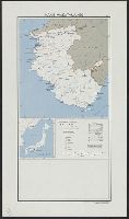
Wakayama-ken (Japan)--Administrative and political divisions--Maps
United States. Department of State. Division of Map Intelligence and Cartography
Published / Created:
[1946?]
Call Number:
57158 1946A
Container / Volume:
BRBL_00309
Image Count:
1
Resource Type:
Maps, Atlases & Globes
Description:
"10071 August 1946.", "Base from A.M.S. L571, first edition, 1943 1:250,000; boundaries and centers of population revised to November 1943.", and Includes ancillary map, glossary, and list of gun.
Publisher:
Dept. of State, Division of Map Intelligence and Cartography/CAHSA,
Subject (Geographic):
Wakayama-ken (Japan)--Administrative and political divisions--Maps