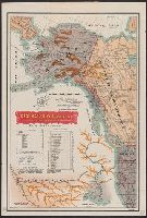
"No. 20"--Upper right margin., "The Yukon River, ranges of mountains, shores of Norton Sound and many features of the interior from a reconnaissance by W.H. Dall, Director of the Scientific Corps, of the W.U. Tel. Expedition, 1865-1868.", and Inset: Aleutian Islands.
Publisher:
U.S. Coast Survey,
Subject (Geographic):
Alaska--Maps and Yukon Territory--Maps
Subject (Name):
Dall, William Healey, 1845-1927 and Lindenkohl, H. (Henry)
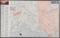
Copper River and adjacent territory, Geological Survey (U.S.). Report, Public resolution ; no. 25, 55th Congress, 3d session., and Its Report, Public resolution ; no. 25, 55th Congress, 3d session
Description:
Contour interval approximately 250 feet., Imperfect: Upper portion of map wanting. Dimensions 35 x 50 cm., and Relief shown by form lines, hachures, and spot heights.
Publisher:
The Survey,
Subject (Geographic):
Alaska--Maps, Chugach Mountains (Alaska)--Maps, and Copper River Region (Alaska)--Maps
Subject (Name):
Abercrombie, W. R.--(William Ralph),--b. 1857, Lowe, P. G, Mahlo, Emil, and Schrader, Frank C. (Frank Charles), 1860-1944
Access routes to Alaska., Golden heart of Alaska., and Great land, Alaska.
Description:
Date inferred from 1949 hunting info. on verso., Golden heart of Alaska -- Access routes to Alaska -- The great land, Alaska., Includes text and ill., Panel title., and Relief shown by hachures and spot heights.
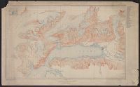
Port Valdez District, Prince William Sound region, Port Valdez District, and Topography, Alaska, Prince William Sound region, Port Valdez District
Description:
"Alaska Sheet no. 602 B.", "Control by Coast and Geodetic Survey. Surveyed in 1911 and 1912.", "Entire area within Chugach National Forest.", Includes index to the mines and prospects in the area and location map., Relief shown by contours and spot heights., and Title, upper center margin: Topography.
Publisher:
The Survey,
Subject (Geographic):
Port Valdez Region (Alaska)--Maps and Prince William Sound Region (Alaska)--Maps
Great Britain. Royal Air Force. Central Interpretation Unit
Published / Created:
1943
Call Number:
475 1944
Container / Volume:
BRBL_00262
Image Count:
1
Resource Type:
Maps, Atlases & Globes
Alternative Title:
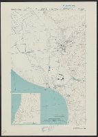
Geographical Section, General Staff ; no. 4415, GSGS (Series) ; 4415., and Vlonë (Valona) city plan
Description:
"1-44.", "1943.", "First G.S.G.S. edition, 1943.", "Ground information supplied by I.S.T.D.", "War Office 1943.", Inset: [Krionero]., Military grid., and Relief shown by contours, land form drawings, and one spot height.