Skip to search
Skip to main content
Skip to first result
Search
You Searched For
Extent of Digitization
Unspecified
Format
cartographic
New Search
Search Results
Creator:
Published / Created:
1595
Call Number:
Z3 017
Collection Title:
John Huighen van Linschoten, his Discours of Voyages into ye Easte & West Indies
Image Count:
1
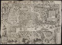
Description:
Bound in following p. 52., Map has numerous repairs on verso with tape., Map has some small tears along fold lines, most notably in the center., and Scale not given.
Subject (Geographic):
Goa (India : State) --Maps and Velha Goa (India)
Subject (Topic):
Voyages and travels --Early works to 1800
Collection Created:
[London] : Printed at London by [John Windet for] Iohn Wolfe, printer to ye Honorable Cittie of London, [1598]
Found in:
Beinecke Rare Book and Manuscript Library > A ilha e cidade de Goa metropolitana da India e partes orientais que esta en 15 graos da Banda do Norte
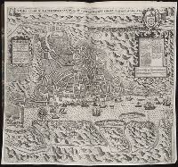
Published / Created:
MDCI [1601]
Call Number:
Taylor 193 3
Collection Title:
Tertia pars Indiae Orientalis ... / de Germanico in Latinum translata, & bono ordine disposita a
Image Count:
1
Description:
In pencil on verso: This map properly at page 73. Part 2.
Subject (Geographic):
Goa (India : State) --Maps and Goa --Description and travel
Collection Created:
Francofurti : Excudebat Matthaeus Beckerus, anno MDCI [1601]
Found in:
Beinecke Rare Book and Manuscript Library > A ilhae cidade de Goa metropolitana da Indiae partes orientais ...
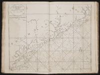
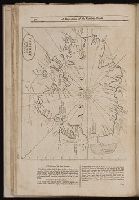
Call Number:
1974 Folio 72
Collection Title:
The English pilot: describing the West-India navigation, from Hudson's-Bay to the river Amazones
Image Count:
1
Subject (Geographic):
Atlantic Ocean --Maps --Early works to 1800 and South Carolina --Maps --Early works to 1800
Subject (Topic):
Navigation --Early works to 1800, Pilot guides --Atlantic Coast (U.S.) --Early works to 1800, and Pilot guides --Caribbean Area --Early works to 1800
Collection Created:
London : Printed for W. and J. Mount, T. Page and son, on Tower-Hill, MDCCLX [1760]
Found in:
Beinecke Rare Book and Manuscript Library > A large draft of South Carolina from Cape Roman to Port Royall
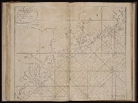
Call Number:
1973 Folio 116
Collection Title:
The English pilot: describing the West-India navigation, from Hudson's-Bay to the river Amazones
Image Count:
1
Subject (Geographic):
Atlantic Ocean --Maps --Early works to 1800 and South Carolina --Maps --Early works to 1800
Subject (Topic):
Navigation --Early works to 1800, Pilot guides --Atlantic Coast (U.S.) --Early works to 1800, and Pilot guides --Caribbean Area --Early works to 1800
Collection Created:
London :
Found in:
Beinecke Rare Book and Manuscript Library > A large draft of South Carolina from Cape Roman to Port Royall
Call Number:
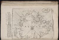
1978 Folio 10
Collection Title:
The English pilot: describing the West-India navigation, from Hudson's-Bay to the river Amazones
Image Count:
1
Subject (Geographic):
Antigua --Maps --Early works to 1800, Atlantic Ocean --Maps --Early works to 1800, and West Indies --Maps --Early works to 1800
Subject (Topic):
Navigation --Early works to 1800, Pilot guides --Atlantic Coast (U.S.) --Early works to 1800, and Pilot guides --Caribbean Area --Early works to 1800
Collection Created:
London : Printed for Thomas Page, William and Fisher Mount, in Postern-Row on Tower-hill, MDCCXXV [1725]
Found in:
Beinecke Rare Book and Manuscript Library > A large draft of the island Antegua
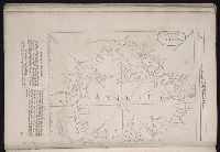
Call Number:
1973 Folio 116
Collection Title:
The English pilot: describing the West-India navigation, from Hudson's-Bay to the river Amazones
Image Count:
1
Subject (Geographic):
Antigua --Maps --Early works to 1800, Atlantic Ocean --Maps --Early works to 1800, and West Indies --Maps --Early works to 1800
Subject (Topic):
Navigation --Early works to 1800, Pilot guides --Atlantic Coast (U.S.) --Early works to 1800, and Pilot guides --Caribbean Area --Early works to 1800
Collection Created:
London :
Found in:
Beinecke Rare Book and Manuscript Library > A large draft of the island Antegua
Call Number:
1974 Folio 72
Collection Title:
The English pilot: describing the West-India navigation, from Hudson's-Bay to the river Amazones
Image Count:
1
Subject (Geographic):
Antigua --Maps --Early works to 1800, Atlantic Ocean --Maps --Early works to 1800, and West Indies --Maps --Early works to 1800
Subject (Topic):
Navigation --Early works to 1800, Pilot guides --Atlantic Coast (U.S.) --Early works to 1800, and Pilot guides --Caribbean Area --Early works to 1800
Collection Created:
London : Printed for W. and J. Mount, T. Page and son, on Tower-Hill, MDCCLX [1760]
Found in:
Beinecke Rare Book and Manuscript Library > A large draft of the island of Antegua
Call Number:
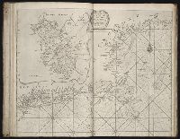
1978 Folio 10
Collection Title:
The English pilot: describing the West-India navigation, from Hudson's-Bay to the river Amazones
Image Count:
1
Subject (Geographic):
Atlantic Ocean --Maps --Early works to 1800, Boston (Mass.) --Maps --Early works to 1800, Boston Harbor (Mass.) --Maps --Early works to 1800, New England --Maps --Early works to 1800, and New York (State) --Maps --Early works to 1800
Subject (Topic):
Navigation --Early works to 1800, Pilot guides --Atlantic Coast (U.S.) --Early works to 1800, and Pilot guides --Caribbean Area --Early works to 1800
Collection Created:
London : Printed for Thomas Page, William and Fisher Mount, in Postern-Row on Tower-hill, MDCCXXV [1725]
Found in:
Beinecke Rare Book and Manuscript Library > A large draught of New England, New York, and Long Island
Call Number:
1976 1233
Collection Title:
Forty-two new maps of Asia, Africa, and America ... : all engrav’d, according to the latest
Image Count:
1
Alternative Title:
America in general
Description:
In ink on verso: 23.
Subject (Geographic):
America --Maps --Early works to 1800, North America --Maps --Early works to 1800, and South America --Maps --Early works to 1800
Subject (Name):
Nicholson, John, d. ca. 1717, bookseller
Subject (Topic):
Atlases --Early works to 1800
Collection Created:
London : Printed for J. Nicholson ..., 1716 ...
Found in:
Beinecke Rare Book and Manuscript Library > A map of America according to ye newest and most exact observations
Published / Created:
1801
Call Number:
Zc90 801mab
Collection Title:
Voyages from Montreal, on the river St. Laurence, through the continent of North America, to the
Image Count:
1
Description:
Map preceding p. 1. and Teaching resource: Professor John Mack Faragher, History 141: The American West.
Publisher:
Published 15 Oct. 1801. by Alexander Mack Kenzie
Subject (Geographic):
Northwest, Canadian --Description and travel
Subject (Topic):
Fur trade --Canada, Indians of North America --Canada, and Indians of North America --Languages --Glossaries, vocabularies, etc.
Collection Created:
London, T. Cadell, Jun. and W. Davies [etc.]; Edinburgh, W. Creech, 1802
Found in:
Beinecke Rare Book and Manuscript Library > A map of America, between latitudes 40 and 70 north and longitudes 45 and 180 west, exhibiting Mackenzie's track from Montreal to Fort Chipewyan & from thence to the North Sea In 1789 & to the West Pacific Ocean in 1793
Branch:v1.61.8 ,Deployed:2024-06-20T11:15:15-04:00