Skip to search
Skip to main content
Skip to first result
Search
You Searched For
Genre
Lithographs
Resource Type
Maps, Atlases & Globes
New Search
Search Results
Published / Created:
1850
Call Number:
1975 Folio 26
Collection Title:
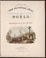
A new universal atlas containing maps of the various empires, kingdoms, states and republics of the
Image Count:
1
Resource Type:
Maps, Atlases & Globes
Subject (Name):
P.S. Duval & Son
Collection Created:
Philadelphia, Thomas, Cowperthwait & Co., No. 253 Market street, 1852
Found in:
Beinecke Rare Book and Manuscript Library > A new map of Maine
Published / Created:
1846
Call Number:
1976 Folio 93
Collection Title:
Mitchell’s universal atlas
Image Count:
1
Resource Type:
Maps, Atlases & Globes
Subject (Geographic):
Maine
Collection Created:
Philadelphia, S.A. Mitchell, 1847, c1844
Found in:
Beinecke Rare Book and Manuscript Library > A new map of Maine
Published / Created:
1854
Call Number:
1976 Folio 96
Collection Title:
A new universal atlas containing maps of the various empires, kingdoms, states and republics of the
Image Count:
1
Resource Type:
Maps, Atlases & Globes
Description:
Chromolith of P.S. Duval & Co. Phila. and Illustrated vignette depicting the first landing of Columbus in the new world.
Collection Created:
Philadelphia, Cowperthwait, DeSilver & Butler, 1854, c1850
Found in:
Beinecke Rare Book and Manuscript Library > A new universal atlas containing maps of the various empires, kingdoms, states and republics of the world ...
Creator:
Published / Created:
1850
Call Number:
1975 Folio 26
Collection Title:
A new universal atlas containing maps of the various empires, kingdoms, states and republics of the
Image Count:
1
Resource Type:
Maps, Atlases & Globes
Collection Created:
Philadelphia, Thomas, Cowperthwait & Co., No. 253 Market street, 1852
Found in:
Beinecke Rare Book and Manuscript Library > A new universal atlas containing maps of the various empires, kingdoms, states and republics of the world ...
Creator:
Published / Created:
[1840]
Call Number:
1973 Folio 105
Collection Title:
Atlas fisico y politico de la Republica de Venezuela ... por ... Agustin Codazzi ...
Image Count:
1
Resource Type:
Maps, Atlases & Globes
Description:
Double page width, tab mounted. and Lith. de Thierry Fres. Cite Bergere 1 a Paris, printers.
Subject (Geographic):
Bolivar (Venezuela : State), Guayana Region (Venezuela)--Maps, Orinoco River Valley (Venezuela and Colombia), and Venezuela --Maps
Subject (Topic):
Physical geography --Venezuela
Collection Created:
Caracas,
Found in:
Beinecke Rare Book and Manuscript Library > Carta del Canton de Angostura de la provincia de la Guayana
Creator:
Published / Created:
[1840]
Call Number:
1973 Folio 105
Collection Title:
Atlas fisico y politico de la Republica de Venezuela ... por ... Agustin Codazzi ...
Image Count:
1
Resource Type:
Maps, Atlases & Globes
Description:
Double page width, tab mounted. and Lith. de Thierry Fres. Cite Bergere 1 a Paris, printers.
Subject (Geographic):
Guayana Region (Venezuela)--Maps, Orinoco River Valley (Venezuela and Colombia), Upata (Venezuela)--Maps, and Venezuela --Maps
Subject (Topic):
Physical geography --Venezuela
Collection Created:
Caracas,
Found in:
Beinecke Rare Book and Manuscript Library > Carta del Canton de Upata de la provincia de la Guayana
Creator:
Published / Created:
[1887]
Call Number:
BrSides Elephant Folio Zc52 887ra
Image Count:
1
Resource Type:
Maps, Atlases & Globes
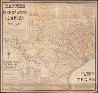
Alternative Title:
Map of the state of Texas.
Description:
Coordinates not present on map and are approximated., Imperfect: Mutilated at upper right, with some loss of text. Mounted on linen., Includes facts and figures about Texas and information about land for sale by E. M. Powell., and Relief shown by hachures.
Publisher:
Rand, McNally & Co.
Subject (Geographic):
Texas--Maps
Subject (Name):
Powell, E. M. (Ernest Malapert)
Found in:
Beinecke Rare Book and Manuscript Library > E.M. Powell's map of the state of Texas.
Published / Created:
[15--]
Call Number:
1978 Folio 106
Collection Title:
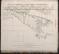
Maps of the Orinoco-Essequibo region, South America. Compiled for the Commission appointed by the
Image Count:
1
Resource Type:
Maps, Atlases & Globes
Subject (Geographic):
Amazon River--Discovery and exploration--Spanish, Amazon River--Maps, Caribbean Area--Maps--Early works to 1800, Colombia --Maps, Guyana --Maps, Orinoco River Valley (Venezuela and Colombia) --Maps, and Venezuela --Maps
Collection Created:
Washington, 1897
Found in:
Beinecke Rare Book and Manuscript Library > Early Spanish map of Guiana
Creator:
Published / Created:
1850
Call Number:
1975 Folio 26
Collection Title:
A new universal atlas containing maps of the various empires, kingdoms, states and republics of the
Image Count:
1
Resource Type:
Maps, Atlases & Globes
Alternative Title:
Heights of the principal mountains in the world
Subject (Name):
P.S. Duval & Son
Collection Created:
Philadelphia, Thomas, Cowperthwait & Co., No. 253 Market street, 1852
Found in:
Beinecke Rare Book and Manuscript Library > Lengths of the principal rivers in the world
Creator:
Published / Created:
[1840]
Call Number:
1973 Folio 105
Collection Title:
Atlas fisico y politico de la Republica de Venezuela ... por ... Agustin Codazzi ...
Image Count:
1
Resource Type:
Maps, Atlases & Globes
Description:
Double page width, tab mounted. and Lith. de Thierry Fres. Cite Bergere 1 a Paris, printers.
Subject (Geographic):
Orinoco River Valley (Venezuela and Colombia), Venezuela --Description and travel, and Venezuela --Maps
Subject (Topic):
Physical geography --Venezuela
Collection Created:
Caracas,
Found in:
Beinecke Rare Book and Manuscript Library > Mapa de las costas de Tierra-Firme desde el Orinoco hasta Yucatan: de las islas Antillas y la mayor parte de las Lucayas, con las derrotas que siguio Dn. Cristobal Colon en sus descubrimientos por estos mares y las derrotas de otros navegantes que reconoc
Branch:v1.61.6 ,Deployed:2024-06-12T09:55:36-04:00