
- None19
You Searched For
« Previous
| 19 - 25 of 25 |
Next »
Search Results
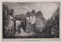
19. A view of the falls on the Passaick, or Second River, in the province of New Jersey the height of the fall between eighty and ninety feet; the river about eighty yards broad = Vue de l'Cataracte du Passaick, ou Seconde Riviere, dans la province de Nouveau Jersey : la hauteur de cette chûte est de 80 à 90 pieds, et la largeur de la riviere d'environ 40 toises / [graphic]
- Creator:
- Sandby, Paul, 1731-1809, printmaker, artist
- Published / Created:
- [1761]
- Call Number:
- 761.00.00.34++
- Image Count:
- 1
- Resource Type:
- still image
- Abstract:
- "View of a waterfall in a canyon with forest surrounding, two small figures standing on the edge of rocks, sun rays piercing through the clouds."--British Museum online catalogue, description of a later state
- Alternative Title:
- Vue de l'Cataracte du Passaick, ou Seconde Riviere, dans la province de Nouveau Jersey and View of the falls on the Passaic, or Second River, in the province of New Jersey
- Description:
- Titles engraved below image, in English and French., State with blank space preceding year "1761" in imprint statement. For another state with day and month "20 May" engraved within that space, see British Library online catalogue, shelfmark: Maps K.Top.122.31.b., Sheet trimmed within plate mark., One of 28 plates in the series: Scenographia Americana., and For a later issue of the plate, with new imprint listing John Bowles, Robert Sayer, and three others as publishers, see British Museum online catalogue, registration no.: 1878,0511.946.
- Publisher:
- Publish'd according to act of Parliament, 1761, by Thos. Jefferys, the corner of St. Martins Lane
- Subject (Geographic):
- Passaic Falls (N.J.) and New Jersey.
- Subject (Topic):
- Rivers and Waterfalls
- Found in:
- Lewis Walpole Library > A view of the falls on the Passaick, or Second River, in the province of New Jersey the height of the fall between eighty and ninety feet; the river about eighty yards broad = Vue de l'Cataracte du Passaick, ou Seconde Riviere, dans la province de Nouveau Jersey : la hauteur de cette chûte est de 80 à 90 pieds, et la largeur de la riviere d'environ 40 toises / [graphic]
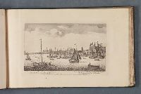
20. A view of the south east prospect of London, from the Tower to London Bridge Vüe de Londres sur du côte du sud-est depuis la Tour jusqu au Pont de Londres. [graphic] =
- Published / Created:
- [1751]
- Call Number:
- Folio 75 L847 750
- Collection Title:
- Leaf 21. London and its environs about 1750.
- Image Count:
- 1
- Resource Type:
- still image
- Abstract:
- "View of London from the Thames, with London Bridge on the left and the Tower on the right; St Paul's beyond the bridge, boats in foreground."--British Museum online catalogue
- Alternative Title:
- View of the southeast prospect of London, from the Tower to London Bridge and Vüe de Londres sur du côte du sud-est depuis la Tour jusqu au Pont de Londres
- Description:
- Titles etched below image, in English and French., Probably a later state, with slight alteration to the plate numbering format. For a state with "No. 2" in upper right corner, see British Museum online catalogue, registration no.: 1875,0710.4905., Date of publication from the British Museum online catalogue., Plate reissued by Sayer and Bennett and listed in their 1775 catalogue as part of the series "Twelve views of the city of London and public buildings therein, accurately engraved from the originals taken on the spot", in the section on "Sets of small prints"; see: Sayer and Bennett's enlarged catalogue of new and valuable prints. London : [Sayer and Bennett], 1775, page 86, no. 8., Plate numbered "2" in upper right corner., and Leaf 21 in an album of views of London and its vicinity.
- Publisher:
- Printed for Robt. Sayer, map & printseller, at the Golden Buck near Serjeants Inn, Fleet Street
- Subject (Geographic):
- London (England), Thames River (England),, London Bridge (London, England),, England, and London.
- Subject (Name):
- Tower of London (London, England), and St. Paul's Cathedral (London, England),
- Subject (Topic):
- Monument, The (London, England), Cathedrals, Bridges, Monuments & memorials, Rivers, Sailboats, and Rowboats
- Found in:
- Lewis Walpole Library > A view of the south east prospect of London, from the Tower to London Bridge Vüe de Londres sur du côte du sud-est depuis la Tour jusqu au Pont de Londres. [graphic] =
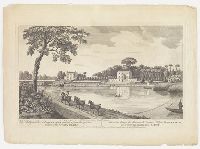
21. Dr. Battys house at Twickenham as view'd from the opposite shore of the River Thames Vüe de la maison de Monsieur le Docteur Batty a Twickenham prise du rivage opposee de la Tamisè. [graphic] =
- Creator:
- Heckel, Augustin, approximately 1690-1770, artist
- Published / Created:
- [not before 1764]
- Call Number:
- Topos M627 no. 12+
- Image Count:
- 1
- Resource Type:
- still image
- Abstract:
- "View looking across the river towards the grand house fronting the Thames; three horses pull a fishing boat in foreground, a tree to the left"--British Museum online catalogue, description of a later state of the same composition
- Alternative Title:
- Doctor Battys house at Twickenham as viewed from the opposite shore of the River Thames and Vüe de la maison de Monsieur le Docteur Batty a Twickenham prise du rivage opposee de la Tamisè
- Description:
- Title from text below image., Artist attribution from original drawing in The Lewis Walpole Library., Date of publication based on the separation of John and Carington Bowles's names in imprint statement. See British Museum online catalogue., Reissue of a print originally published in 1749 by John Bowles. See British Museum online catalogue., "Publish'd according to act of Parliament"--Below image., No. 10, "Hon. George Shirley," on Edith McKeon Abbott's map: Horace Walpole's Twickenham 1747-1797, in v. 42 of the Yale Edition of Horace Walpole's Correspondence. New Haven: Yale University Press, 1980., No. 12, "Dr. William Battie," on Edith McKeon Abbott's map: Horace Walpole's Twickenham 1747-1797, in v. 42 of the Yale Edition of Horace Walpole's Correspondence. New Haven: Yale University Press, 1980., and Watermark: J. Whatman.
- Publisher:
- Printed for John Bowles, No. 13 in Cornhill & Carington Bowles, No. 69 in St. Pauls Church Yard
- Subject (Geographic):
- Twickenham (London, England), Thames River (England),, England, and Twickenham.
- Subject (Name):
- Batty, Robert, 1763?-1849
- Subject (Topic):
- Homes and haunts, Buildings, structures, etc, Houses, Estates, Rivers, Horses, and Boats
- Found in:
- Lewis Walpole Library > Dr. Battys house at Twickenham as view'd from the opposite shore of the River Thames Vüe de la maison de Monsieur le Docteur Batty a Twickenham prise du rivage opposee de la Tamisè. [graphic] =
22. Lambeth the Archbishop of Canterbury's Palace Lambeth le Palais, de L'Archveque de Canterbury. [graphic] =
- Published / Created:
- [not before 1747]
- Call Number:
- Folio 75 L847 750
- Collection Title:
- Leaf 29. London and its environs about 1750.
- Image Count:
- 1
- Resource Type:
- still image
- Abstract:
- "View of the palace from Millbank; St Paul's in the distance to the left, boats and figures in foreground."--British Museum online catalogue
- Alternative Title:
- Lambeth le Palais, de L'Archveque de Canterbury
- Description:
- Titles etched below image, in English and French., Date of publication based on Robert Sayer's earliest year of activity. The address "near Sergeants Inn, Fleet Street" only appears on his very early prints; see British Museum online catalogue., Plate reissued by Sayer and Bennett and listed in their 1775 catalogue as part of the series "Twelve views of his Majesty's palaces and royal hospitals, and other public buildings in London, &c.", in the section on "Sets of small prints"; see: Sayer and Bennett's enlarged catalogue of new and valuable prints. London : [Sayer and Bennett], 1775, page 87, no. 9., Plate numbered "10" in upper right corner., Watermark: 1804., and Leaf 29 in an album of views of London and its vicinity.
- Publisher:
- Printed for Robt. Sayer, map & printseller, at the Golden Buck near Serjeants Inn, Fleet Street
- Subject (Geographic):
- London (England) and Thames River (England),
- Subject (Name):
- Lambeth Palace, and St. Paul's Cathedral (London, England),
- Subject (Topic):
- Castles & palaces, Official residences, Rivers, and Boats
- Found in:
- Lewis Walpole Library > Lambeth the Archbishop of Canterbury's Palace Lambeth le Palais, de L'Archveque de Canterbury. [graphic] =

23. The Royal Palace of Windsor Le Palais Royale de Windsor. [graphic] =
- Published / Created:
- [not before 1747]
- Call Number:
- Folio 75 L847 750
- Collection Title:
- Leaf 19. London and its environs about 1750.
- Image Count:
- 1
- Resource Type:
- still image
- Abstract:
- View of Windsor Castle from across the river Thames, with boats on the water and two swans to the left. Three men with fishing poles and two women are seen on the bank in the foreground; a tree stands on the right
- Alternative Title:
- Palais Royale de Windsor
- Description:
- Titles etched below image, in English and French., Date of publication based on Robert Sayer's earliest year of activity. The address "near Sergeants Inn, Fleet Street" only appears on his very early prints; see British Museum online catalogue., Plate reissued by Sayer and Bennett and listed in their 1775 catalogue as part of the series "Twelve views of his Majesty's palaces and royal hospitals, and other public buildings in London, &c.", in the section on "Sets of small prints"; see: Sayer and Bennett's enlarged catalogue of new and valuable prints. London : [Sayer and Bennett], 1775, page 87, no. 9., Imperfect; plate number erased from upper right corner of sheet. Missing number supplied from impression in the Victoria and Albert Museum, accession no.: 29635:13., Plate numbered "8" in upper right corner., Watermark: 1804., and Leaf 19 in an album of views of London and its vicinity.
- Publisher:
- Printed for Robt. Sayer, map & printseller, at the Golden Buck near Serjeants Inn, Fleet Street
- Subject (Geographic):
- Berkshire (England) and Thames River (England),
- Subject (Name):
- Windsor Castle,
- Subject (Topic):
- Castles & palaces, Official residences, Rivers, and Boats
- Found in:
- Lewis Walpole Library > The Royal Palace of Windsor Le Palais Royale de Windsor. [graphic] =

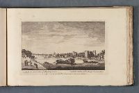
24. The north view of Battersea La veüe de Battersea au nord. [graphic] =
- Published / Created:
- [not before 1747]
- Call Number:
- Folio 75 L847 750
- Collection Title:
- Leaf 8. London and its environs about 1750.
- Image Count:
- 1
- Resource Type:
- still image
- Abstract:
- "View of Battersea, looking across the River Thames; a church in centre of view flying a flag, the river busy with barges and other boats; figures on river bank including a man fishing, a tall tree to the right."--British Museum online catalogue
- Alternative Title:
- Veüe de Battersea au nord
- Description:
- Titles etched below image, in English and French., Date of publication based on Robert Sayer's earliest year of activity. The address "near Sergeants Inn, Fleet Street" only appears on his very early prints; see British Museum online catalogue., Plate reissued by Sayer and Bennett and listed in their 1775 catalogue as part of the series "Views of villages, noblemen and gentlemen's seats, &c. situate on, or near the river Thames", in the section on "Sets of small prints"; see: Sayer and Bennett's enlarged catalogue of new and valuable prints. London : [Sayer and Bennett], 1775, page 88, no. 13., Plate numbered "7" in upper right corner., Mounted to 24 x 38 cm., and Leaf 8 in an album of views of London and its vicinity.
- Publisher:
- Printed for Robert Sayer, map & printseller near Serjeants Inn, Fleet Street
- Subject (Geographic):
- Battersea (London, England), Thames River (England), England, and London.
- Subject (Topic):
- Rivers, Churches, Flags, Barges, Sailboats, and Rowboats
- Found in:
- Lewis Walpole Library > The north view of Battersea La veüe de Battersea au nord. [graphic] =
25. The north view of Row-Hampton La veüe de Row-Hampton au nord. [graphic] =
- Published / Created:
- [not before 1747]
- Call Number:
- Folio 75 L847 750
- Collection Title:
- Leaf 6. London and its environs about 1750.
- Image Count:
- 1
- Resource Type:
- still image
- Abstract:
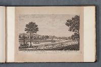
- "View with the river at the centre, boats on the water, a man rasing his sail in the left, figures walking on the path in the foreground, including a man on horseback and a man fishing by the river; the city in the background."--British Museum online catalogue
- Alternative Title:
- North view of Roehampton and Veüe de Row-Hampton au nord
- Description:
- Titles etched below image, in English and French., Date of publication based on Robert Sayer's earliest year of activity. The address "near Sergeants Inn, Fleet Street" only appears on his very early prints; see British Museum online catalogue., Plate reissued by Sayer and Bennett and listed in their 1775 catalogue as part of the series "Views of villages, noblemen and gentlemen's seats, &c. situate on, or near the river Thames", in the section on "Sets of small prints"; see: Sayer and Bennett's enlarged catalogue of new and valuable prints. London : [Sayer and Bennett], 1775, page 88, no. 13., Plate numbered "5" in upper right corner., Mounted to 24 x 39 cm., and Leaf 6 in an album of views of London and its vicinity.
- Publisher:
- Printed for Robert Sayer, map & printseller near Serjeants Inn, Fleet Street
- Subject (Geographic):
- Roehampton (London, England), Thames River (England), England, and London.
- Subject (Topic):
- Rivers, Trails & paths, Sailboats, and Rowboats
- Found in:
- Lewis Walpole Library > The north view of Row-Hampton La veüe de Row-Hampton au nord. [graphic] =