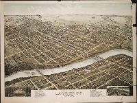
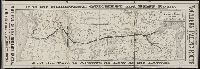
Print shows a bird's eye view of Lawrence, Kansas in 1880 numbered with 33 points of interest and indexed under the title "The New," to left of print's title caption; and, in the lower right, a map insert labeled, "Lawrence in 1855" numbered with 20 points of interest and indexed under the title "The Old," to right of the print's title caption
Description:
BEIN BrSides Zc39 880mo copy 1: Imperfect: lower right corner of sheet, upper right margin, and small section of right hand side broken off; a tear across sheet from right to center about one third up sheet. On sheet 62 x 82 cm., BEIN BrSides Zc39 880mo copy 2: On sheet 64 x 82 cm., Title from caption below image., Pictorial representation., and "Copyright by D.D. Morse, 1880."
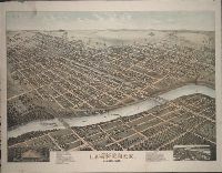
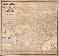
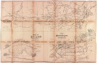
Coordinates not present on map and are approximated., Imperfect: Mutilated at upper right, with some loss of text. Mounted on linen., Includes facts and figures about Texas and information about land for sale by E. M. Powell., and Relief shown by hachures.
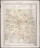
Leaflet advertising the Northern Pacifics route from Minneapolis to the Pacific Northwest, including schedules of trains, land for sale, and connecting stagecoaches.
Publisher:
Rand, McNally & Co., Printers
Subject (Name):
Northern Pacific Railroad Company
Subject (Topic):
Dakota Territory., Montana., Washington (State), and West (U.S.)
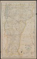
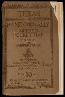
Indexed pocket map, tourists' and shippers' guide of Texas, Texas, Rand McNally indexed pocket map, tourists' and shippers' guide, Rand McNally standard map of Texas, Standard map of Texas, Rand McNally new commercial atlas map of Texas, and New commercial atlas map of Texas
Description:
BEIN Covers 796 1921: Original wrappers. Inscription on front cover: Malcolm R. Thorpe., Relief shown by hachures and spot heights., Shows railroads and counties., Title from index., Includes insets of the panhandle and southern Texas, and indexes., and On verso: Rand McNally main highway map of Texas. Scale [ca. 1:1,267,200].
Publisher:
Rand McNally
Subject (Geographic):
Texas and Texas Panhandle (Tex.)
Subject (Topic):
Administrative and political divisions and Railroads