Skip to search
Skip to main content
Skip to first result
Search
You Searched For
Format
cartographic
Language
Italian
New Search
Search Results
Published / Created:
1919
Call Number:
11hcf 1919E-3
Container / Volume:
BRBL_00010ZA
Image Count:
1
Resource Type:
Maps, Atlases & Globes
Description:
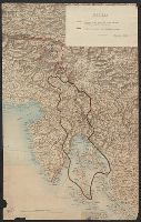
"2 November 1919." and Shows demilitarized zones.
Publisher:
s.n.,
Subject (Geographic):
Croatia--Maps and Italy--Maps
Found in:
Beinecke Rare Book and Manuscript Library > [Map showing the Trieste-Isonzo region, including Fiume.]
Published / Created:
1920
Call Number:
2006 2042
Collection Title:
La questione di Fiume / Alceste de Ambris
Image Count:
1
Description:
p. 41
Subject (Geographic):
Rijeka (Croatia) --Economic conditions and Rijeka (Croatia) --History --Siege, 1919.
Subject (Topic):
Dismemberment of nations, Partition, Territorial, Railroads, and World War, 1914-1918 --Territorial questions --Croatia --Rijeka.
Collection Created:
Roma : La Fionda, 1920
Found in:
Beinecke Rare Book and Manuscript Library > [Map: Il nodo ferroviario di S. Pietro del Carso]
Published / Created:
1920
Call Number:
2006 2042
Collection Title:
La questione di Fiume / Alceste de Ambris
Image Count:
1
Description:
Facing p. 32
Subject (Geographic):
Rijeka (Croatia) --Economic conditions and Rijeka (Croatia) --History --Siege, 1919.
Subject (Topic):
Dismemberment of nations, Partition, Territorial, and World War, 1914-1918 --Territorial questions --Croatia --Rijeka.
Collection Created:
Roma : La Fionda, 1920
Found in:
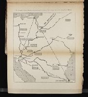
Beinecke Rare Book and Manuscript Library > [Map: Il triangolo Fiume-Danzica-Constantinopoli e le linee ferroviarie di accesso al porto di Fiume]
Published / Created:
1920
Call Number:
2006 2042
Collection Title:
La questione di Fiume / Alceste de Ambris
Image Count:
1
Description:
p. 23
Subject (Geographic):
Rijeka (Croatia) --Economic conditions and Rijeka (Croatia) --History --Siege, 1919.
Subject (Topic):
Dismemberment of nations, Partition, Territorial, and World War, 1914-1918 --Territorial questions --Croatia --Rijeka.
Collection Created:
Roma : La Fionda, 1920
Found in:
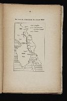
Beinecke Rare Book and Manuscript Library > [Map: La linea del compromesso 14 gennaio 1920]
Published / Created:
1920
Call Number:
2006 2042
Collection Title:
La questione di Fiume / Alceste de Ambris
Image Count:
1
Description:
p. 19
Subject (Geographic):
Rijeka (Croatia) --Economic conditions and Rijeka (Croatia) --History --Siege, 1919.
Subject (Topic):
Dismemberment of nations, Partition, Territorial, and World War, 1914-1918 --Territorial questions --Croatia --Rijeka.
Collection Created:
Roma : La Fionda, 1920
Found in:
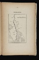
Beinecke Rare Book and Manuscript Library > [Map: La linea di Wilson]
Published / Created:
[1918?]
Call Number:
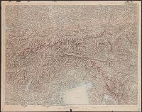
40 1918
Container / Volume:
BRBL_00202
Image Count:
1
Resource Type:
Maps, Atlases & Globes
Description:
Shows pre-war boundaries and the Armistice line, Nov. 3, 1918. and Title supplied by cataloger.
Publisher:
Instituto Geografico Militare,
Subject (Geographic):
Italy, Northern--Maps
Found in:
Beinecke Rare Book and Manuscript Library > [New Boundaries of Italy in the Northeast].
Published / Created:
1892?]
Call Number:
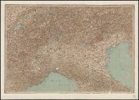
40 1892
Container / Volume:
BRBL_00202
Image Count:
2
Resource Type:
Maps, Atlases & Globes
Description:
Stamp on verso: "Officiers-Bibliotek des k.k. Landwehr-Infanterie-Regiments Brünn Nr. 14."
Publisher:
s.n.,
Subject (Geographic):
Italy, Northern--Maps
Found in:
Beinecke Rare Book and Manuscript Library > [Northern Italy].
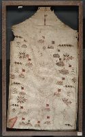
Published / Created:
[1550?]
Call Number:
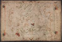
488 1550
Container / Volume:
BRBL_00706
Image Count:
1
Resource Type:
Maps, Atlases & Globes
Description:
Color: red, purple, some gold and green. and Preliminary record.
Subject (Geographic):
Aegean Sea--Maps, Manuscript--Early works to 1800
Found in:
Beinecke Rare Book and Manuscript Library > [Portolan chart of the Aegean Sea].
Published / Created:
1590
Call Number:
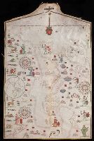
49cea 1590
Image Count:
2
Resource Type:
Maps, Atlases & Globes
Description:
Colors: red, greens, and blues., Crucifix at top of map., Inset: The world., Joan Riezo figlo de mastro dominico [Olives] in missina año 1590., and Notes: gold ribbon along borders of map, missing from far right hand side.
Subject (Geographic):
Europe--Maps--Early works to 1800 and Mediterranean Sea--Maps--Early works to 1800
Found in:
Beinecke Rare Book and Manuscript Library > [Portolan chart of the Mediterranean Sea and Europe].
Creator:
Published / Created:
[approximately 1587]
Call Number:
Art Storage 49cea 1587
Image Count:
2
Resource Type:
Maps, Atlases & Globes
Description:
Contains seven compass roses., Decoration: city views with banners; Jesus Christ on a cross at left edge., Label on verso: Vend. del 4.VI.32-X., Pen-and-ink in black, red, blue and green., Portolan chart with seaport names given for all coastlines., and Title devised by cataloger.
Subject (Geographic):
Black Sea--Maps--Early works to 1800. and Mediterranean Sea--Maps--Early works to 1800.
Subject (Topic):
Nautical charts--Black Sea--Early works to 1800. and Nautical charts--Mediterranean Sea--Early works to 1800.
Found in:
Beinecke Rare Book and Manuscript Library > [Portolan chart of the Mediterranean Sea and the Baltic Sea].
Branch:v1.61.6 ,Deployed:2024-06-12T09:55:36-04:00