Appears in various eds. of Atlas geographicus maior., Includes German text relating to English and French territorial claims., Place names and descriptive notes in English., Prime meridian: Ferro and London., Relief shown pictorially., and Sheet measures 49.5 x 61.7 cm. Title in ms. on verso. Franklin Collection no. 131 1777-1.
Publisher:
[s.n.],
Subject (Geographic):
North America--Maps--Early works to 1800 and United States--History--French and Indian War, 1755-1763--Maps--Early works to 1800
Subject (Name):
Anville, Jean Baptiste Bourguignon d', 1697-1782 and Homann Erben (Firm). Atlas geographicus maior
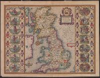
From Speed's The theatre of the empire of Great Britaine., Hand col. Sheet measures 42 x 55 cm. Lanman Collection., Left and right borders contain illustrations of notable persons from each of the 14 political districts., and Running title on verso: Heptarchiae
Publisher:
Are to be sold by John Sudbury & Georg. Humble,
Subject (Geographic):
Great Britain--Maps--Early works to 1800
Subject (Name):
Humble, George, d. 1640, Speed, John, 1552?-1629. Theatre of the Empire of Great Britaine, and Sudbury, John
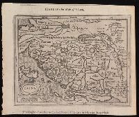
Hondius his map of China and Hondivs his map of China
Description:
North oriented towards the right., Relief shown pictorially., Removed from Samuel Purchas's Purchas his Pilgrimage (1625)., and Text in English on verso.
Publisher:
[Printed by William Stansby for Henrie Fetherstone],
Subject (Geographic):
China.
Subject (Name):
Featherstone, Henry, -1647, bookseller, Purchas, Samuel, 1577?-1626. Purchas his Pilgrimage. 1625., and Stansby, William, active 1597-1638, printer
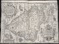
John Huighen van Linschoten, his Discours of Voyages into ye Easte & West Indies
Image Count:
1
Description:
[Scale ca. 1:13,500,000]., Bound in following p. 10., Map has one small hole (burn mark?) just to the left of the land mass of Madagascar., and Map has one small tear along bottom fold line in the center.
Subject (Geographic):
Africa --Maps --Early works to 1800, Africa, East --Maps, and Madagascar --Maps --Early works to 1800
Subject (Name):
Wolfe, John, d. 1601, printer
Subject (Topic):
Voyages and travels --Early works to 1800
Collection Created:
[London] : Printed at London by [John Windet for] Iohn Wolfe, printer to ye Honorable Cittie of London, [1598]
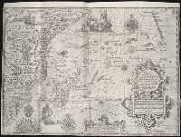
John Huighen van Linschoten, his Discours of Voyages into ye Easte & West Indies
Image Count:
1
Description:
[Scale ca. 1:13,500,000]. and Bound in following p. 10.
Subject (Geographic):
Africa --Maps --Early works to 1800, Arabian Peninsula --Maps --Early works to 1800, Arabian Sea --Charts, maps, etc., Armenia (Republic) --Maps, Asia --Maps --Early works to 1800, Bengal, Bay of --Maps, Cyprus --Maps --Early works to 1800, India --Maps --Early works to 1800, Mediterranean Sea --Maps --Early works to 1800, Syria --Maps, Tigris River Valley, and Yemen --Maps --Early works to 1800
Subject (Name):
Wolfe, John, d. 1601, printer
Subject (Topic):
Voyages and travels --Early works to 1800
Collection Created:
[London] : Printed at London by [John Windet for] Iohn Wolfe, printer to ye Honorable Cittie of London, [1598]
John Huighen van Linschoten, his Discours of Voyages into ye Easte & West Indies
Image Count:
1
Description:
[Scale ca. 1:13,500,000]., Bound in following p. 32., and Map has several small brown marks on the left portion that can also be seen on the verso.
Subject (Geographic):
Borneo --Maps --Early works to 1800, China --Maps --1368-1644, Japan --Maps --Early works to 1800, Java (Indonesia) --Maps --Early works to 1800, and Sumatra (Indonesia) --Maps
Subject (Name):
Wolfe, John, d. 1601, printer
Subject (Topic):
Voyages and travels --Early works to 1800
Collection Created:
[London] : Printed at London by [John Windet for] Iohn Wolfe, printer to ye Honorable Cittie of London, [1598]
Bat. cum Privil. Ordin. Gener, Belgii Faederati--Title cartouche., Features include ornate title cartouche (top left) with cherubs, male and female figures and royal coat-of-arms supported by lion and unicorn, arms of Scotland supported by cherubs (above scale cartouche at top right), compass indicator and coasts shaded outwards., In Latin with some place names in English; explanations and title for index to places in Dutch and English., No. 7 of 69 maps bound together in composite atlas., Relief shown pictorially., Scale [ca. 1:960 000]., Scale statement reads: Milliaria Germanica Communia 15 in uno Gradu, with scale bar graded [0]-10; Milliaria Scotica Communia quorum 50 in uno Gradu, with scale bar graded [0]-34; Milliaria Gallica quae et Horae Itineris 20 in uno Gradu, with scale bar graded [0]-14., Shows grid, rivers and tributaries, lochs (shaded), trees, place and county names, settlements (symbols classified by importance in legend), territorial boundaries., Shows Scotland including the Hebrides and Orkney Islands., and The four cardinal points are written in the borders.