
You Searched For
1 - 7 of 7
Search Results


- Creator:
- Anville, Jean Baptiste Bourguignon d', 1697-1782
- Published / Created:
- 1779
- Call Number:
- 90 1779
- Container / Volume:
- BRBL_00661
- Image Count:
- 2
- Resource Type:
- Maps, Atlases & Globes
- Description:
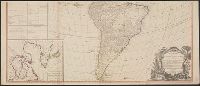
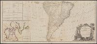
- Both sheets backed with paper., Includes text and historical notes., Inset: Chart of Falkland Islands named by the French Malouine Islands and discovered by Hawkins in the year 1593., Outline color., Prime meridian: Ferro., Relief sh, and Watermarks on both sheets.
- Publisher:
- Sayer and Bennett,
- Subject (Geographic):
- Falkland Islands--Maps--Early works to 1800 and South America--Maps--Early works to 1800
- Subject (Name):
- Robert Sayer and John Bennett (Firm)
- Found in:
- Beinecke Rare Book and Manuscript Library > A map of South America containing Tierra-Firma, Guayana, New Granada, Amazonia, Brasil, Peru, Paraguay, Chaco, Tucuman, Chili and Patagonia [cartographic material] : from Mr. d'Anville, with several improvements and additions, and the newest discoveries /
3.
- Creator:
- Anville, Jean Baptiste Bourguignon d', 1697-1782
- Published / Created:
- 1794
- Call Number:
- 70 1794
- Container / Volume:
- BRBL_00686
- Image Count:
- 2
- Resource Type:
- Maps, Atlases & Globes
- Description:
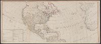
- "Publish'd by Laurie & Whittle, No. 53 Fleet Street, as the Act directs, 12th May 1794.", Appears in Thomas Kitchin's General atlas, describing the whole universe., Includes table, "The Continent and Islands of America are Divided and Possessed as follows viz.", Inset: The supplement to North America containing the countries adjoining to Baffins & Hudson bays., Joined into two sheets measuring 53.8 x 121.6 cm. and 53.8 x 121.2 cm. Stamped number on top sheet: 60. Stamped number on top sheet: 61. Cross Collection no. 139., Prime meridian: Ferro., Re-issue of John Gibson's map of [1763], 1772, 1777, 1783, and 1786., Relief shown pictorially., Shows the Western Hemisphere with some political borders, tabular information indicates national possessions; cities and rivers., and Title from ornamental cartouche.
- Publisher:
- Laurie & Whittle,
- Subject (Geographic):
- America--Maps--Early works to 1800 and West Indies--Maps--Early works to 1800
- Subject (Name):
- Gibson, J. (John), Kitchin, Thomas, d. 1784. General atlas describing the whole universe, Pownall, Thomas, 1722-1805, and Robert Laurie and James Whittle
- Found in:
- Beinecke Rare Book and Manuscript Library > A new map of the whole continent of America : divided into North and South and West Indies wherein are exactly described the United States of North America as well as the several European possessions according to the preliminaries of peace signed at Versa
4.
- Creator:
- Anville, Jean Baptiste Bourguignon d', 1697-1782
- Published / Created:
- 1794
- Call Number:
- 70 1794
- Container / Volume:
- BRBL_00725
- Image Count:
- 2
- Resource Type:
- Maps, Atlases & Globes
- Description:
- "Publish'd by Laurie & Whittle, No. 53 Fleet Street, as the Act directs, 12th May 1794.", Appears in Thomas Kitchin's General atlas, describing the whole universe., Copy 2: Joined into two sheets measuring 53.7 x 125.6 cm. and 53.7 x 125.6 cm. Stamped number on sheets: 34. Franklin Collection no. 131 1794 11-12., Includes table, "The Continent and Islands of America are Divided and Possessed as follows viz.", Inset: The supplement to North America containing the countries adjoining to Baffins & Hudson bays., Prime meridian: Ferro., Re-issue of John Gibson's map of [1763], 1772, 1777, 1783, and 1786., Relief shown pictorially., Shows the Western Hemisphere with some political borders, tabular information indicates national possessions; cities and rivers., and Title from ornamental cartouche.
- Publisher:
- Laurie & Whittle,
- Subject (Geographic):
- America--Maps--Early works to 1800 and West Indies--Maps--Early works to 1800
- Subject (Name):
- Gibson, J. (John), Kitchin, Thomas, d. 1784. General atlas describing the whole universe, Pownall, Thomas, 1722-1805, and Robert Laurie and James Whittle
- Found in:
- Beinecke Rare Book and Manuscript Library > A new map of the whole continent of America : divided into North and South and West Indies wherein are exactly described the United States of North America as well as the several European possessions according to the preliminaries of peace signed at Versa
5.
- Creator:
- Anville, Jean Baptiste Bourguignon d', 1697-1782
- Published / Created:
- 1794
- Call Number:
- 70 1794
- Container / Volume:
- BRBL_00725
- Image Count:
- 2
- Resource Type:
- Maps, Atlases & Globes
- Description:
- "Publish'd by Laurie & Whittle, No. 53 Fleet Street, as the Act directs, 12th May 1794.", Appears in Thomas Kitchin's General atlas, describing the whole universe., Copy 3: Joined into two sheets measuring 54.7 x 123.5 cm. and 54.6 x 123.4 cm. Stamped number on top sheet: 32. Stamped number on top sheet: 33. Franklin Collection no. 131 1794 13-14., Includes table, "The Continent and Islands of America are Divided and Possessed as follows viz.", Inset: The supplement to North America containing the countries adjoining to Baffins & Hudson bays., Prime meridian: Ferro., Re-issue of John Gibson's map of [1763], 1772, 1777, 1783, and 1786., Relief shown pictorially., Shows the Western Hemisphere with some political borders, tabular information indicates national possessions; cities and rivers., and Title from ornamental cartouche.
- Publisher:
- Laurie & Whittle,
- Subject (Geographic):
- America--Maps--Early works to 1800 and West Indies--Maps--Early works to 1800
- Subject (Name):
- Gibson, J. (John), Kitchin, Thomas, d. 1784. General atlas describing the whole universe, Pownall, Thomas, 1722-1805, and Robert Laurie and James Whittle
- Found in:
- Beinecke Rare Book and Manuscript Library > A new map of the whole continent of America : divided into North and South and West Indies wherein are exactly described the United States of North America as well as the several European possessions according to the preliminaries of peace signed at Versa
- Creator:
- Anville, Jean Baptiste Bourguignon d', 1697-1782
- Published / Created:
- 1794
- Call Number:
- 38 1794
- Container / Volume:
- BRBL_00153
- Image Count:
- 1
- Resource Type:
- Maps, Atlases & Globes
- Description:
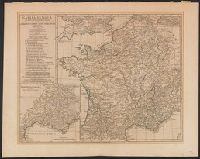
- Below title: "MDCCLX, apud auctorem ... ", Inset maps: Provinciæ Romanæ ferè integræ tabula specialis et amplior. Scale [ca. 1:1,870,000] -- Batavorum Insulæ plenior descriptio., Prime meridian: Ferro., and Relief shown pictorially.
- Publisher:
- Published ... by Laurie & Whittle,
- Subject (Geographic):
- France--History--To 987--Maps--Early works to 1800 and Gaul--History--Maps--Early works to 1800
- Subject (Name):
- Robert Laurie and James Whittle, publishers
- Found in:
- Beinecke Rare Book and Manuscript Library > Gallia Antiqua ex Ævi Romani monumentis : eruta et serenissimi Carnutum Ducis munificientia publicijuris facta / auctor d'Anville.
7.

- Creator:
- Anville, Jean Baptiste Bourguignon d', 1697-1782
- Published / Created:
- 1821
- Call Number:
- 400 1821
- Container / Volume:
- BRBL_00233
- Image Count:
- 1
- Resource Type:
- Maps, Atlases & Globes
- Description:
- Includes 2 insets of Rome city region and "Urbs septicollis." and Relief shown pictorially.
- Publisher:
- R.H. Laurie,
- Subject (Geographic):
- Italy--Historical geography--Maps, Italy--History--To 476--Maps, and Rome--Maps
- Found in:
- Beinecke Rare Book and Manuscript Library > Tabula Italiae antiquae geographica : quam excellentissimus dominus Dux de la Rochefoucauld in aere incidi curavit / auctor d'Anville ... MDCCLXIV.