From Jefferys's The American atlas ... London : Printed and sold by R. Sayer and J. Bennett, 1776. and Insets: A particular survey of the Isles of Montreal -- The city of Quebec -- Course of the river St. Laurence, from La Valterie to Quebec -- Plan of Montreal, or Víllemarie.
Publisher:
Printed for Robt. Sayer and John Bennett,
Subject (Geographic):
Québec (Province)--Maps--Early works to 1800
Subject (Name):
Jefferys, Thomas, -1771. American atlas and Robert Sayer and John Bennett (Firm)
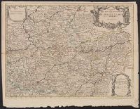
Appears in Senex's New general atlas., Cross collection no. 74., Dedicated to John Richmond Webb; dedication shows evidence of previous cartographer's name being removed and replaced by that of John Senex., London meridian., Relief shown pictorially., and Shows boundaries, rivers, forests and settlements.
Publisher:
John Senex],
Subject (Geographic):
Cambrai (France)--Maps--Early works to 1800, Hainaut (County)--Maps--Early works to 1800, and Namur (Belgium)--Maps--Early works to 1800
Subject (Name):
Senex, John, d. 1740, dedicator, Senex, John, d. 1740. New general atlas, and Webb, John Richmond, dedicatee
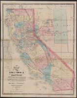
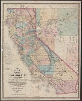
"Entered according to act of Congress in the year 1863 by Warren Holt ....", Includes distance table and index to land districts., Relief shown by hachures., Shows drainage, townships, mining districts, etc., and Unlike another variant, this does not contain statement "Lith. by L. Nagel," and has other variations including name "Arizona Ter." in lower right margin.
Publisher:
W. Holt,
Subject (Geographic):
California--Maps and Nevada--Maps
Subject (Name):
Doolittle, A. J and Holt, Warren
Subject (Topic):
Mining districts--California--Maps and Mining districts--Nevada--Maps
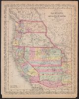
"Entered according to act of Congress in the year 1856 by Charles Desilver in the clerks office of the district court of the eastern district of Pennsylvania."
"Entered according to Act of Congress in the year 1869 by Warren Holt, in the clerk's office of the District Court of the Northern District of the state of California.", Also shows mining districts., and Includes distance table and index to "United States land districts."
Publisher:
W. Holt,
Subject (Geographic):
California--Maps and Nevada--Maps
Subject (Name):
Holt, Warren
Subject (Topic):
Mining districts--California--Maps and Mining districts--Nevada--Maps
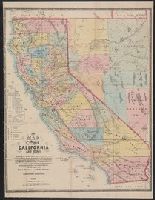
"Entered according to Act of Congress in the year 1869 by WarrenHolt, in the clerk's office of the District Court of the Northern District of the state of California.", Also shows mining districts., and Includes index to "United States land districts" and distance chart.
Publisher:
W. Holt,
Subject (Geographic):
California--Maps and Nevada--Maps
Subject (Name):
Baker, Geo. H. (George Holbrook), 1827-1906, Doolittle, A. J, and Holt, Warren
Subject (Topic):
Mining districts--California--Maps and Mining districts--Nevada--Maps
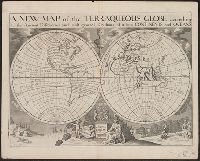
"Dedicated to His Highness William Duke of Gloucester.", "Delin. M. Burghers sculpt. Univ. Oxon.", Cross collection no. 32., Plate mark 1 was added below the dedication plinth for the editions in 1726 and 1738--Cf. Shirley., and Scale measured at center of hemisphere.
Publisher:
s.n.,
Subject (Name):
Burghers, M and Wells, Edward, 1667-1727. New sett of maps both of antient and present geography
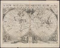
"Dedicated to His Highness William Duke of Gloucester.", "Delin. M. Burghers sculpt. Univ. Oxon.", Appeared in Wells' New sett of maps both of antient and present geography., Cross collection no. 31., Double hemisphere on sheet in outline, with rivers, capes and island marked but few other place names., Plate mark 2 was added below the dedication plinth for the editions in 1726 and 1738--Cf. Shirley., Scale measured at center of hemisphere., and Slip pasted to verso of map: Property of Andrew Arthur Benton, New York, N.Y.
Publisher:
s.n.,
Subject (Name):
Benton, Andrew Arthur--Ownership, Burghers, M, and Wells, Edward, 1667-1727. New sett of maps both of antient and present geography