Bar scales given in English miles, 60 in a degree, Irish miles, 50 in a degree, and Dutch miles, 15 in a degree., Drawn from the survey made by Sr. Wm. Petty ; divided into its provinces, counties, and barronies, shewing also its bishopricks, borroughs, highwaies ... ; improved with many additions not extent in any other map., Includes inset map The sea coast of England, Scotland, and Ireland, Holland & part of France., No. 8 of 69 maps bound together in composite atlas., and Scale [ca. 1:540 000].
Publisher:
Sold by Rob. Morden at the Atlas in Corn-hil and by Christ. Brown at the Globe and Compasses in St. Pauls Churchyard
No. 18 of 43 maps bound together in composite atlas., Reduite d'apres la grande carte pour trouver facilement ce qu'on a envie de chercher dans celle-la., Relief shown pictorially., Scale [ca 1:3,750,000]., Table alphabetique des villes ... qui se trouvent dans cette carte., and With inset map: Morceau detache qui represente l'acroissement des etats de sa majeste le roi de Sardaigne, depuis l'an 1680.
Ferro meridian., No. 38 of 43 maps bound together in composite atlas., Relief shown by hachures., Scale [1:1,750,000]., and Shows rivers and settlements.
Subject (Geographic):
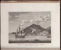
Egypt --Maps --Early works to 1800 and Nile River --Maps --Early works to 1800
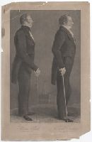
Print reproduces a pair of full-length portraits of Hyrum and Joseph Smith drawn by Maudsley from originals painted by David Rogers; an image of the Temple at Nauvoo, in reduced scale, is shown between the figures of the two men; the two men are dressed formally, hold walking sticks in their right hands, and face right in profile.
Alternative Title:
Temple of Nauvoo
Description:
Another state of this image, colored and with slightly different letters, includes the imprint, London: Moses Martin, 1847., Below image: Temple of Nauvoo., and Title from caption.
Publisher:
[Moses Martin?]
Subject (Name):
Le Blond & Co., engraver, Maudsley, Sutcliffe, 1809-1881, artist, Nauvoo Temple (Nauvoo, Ill. : 1841-1850)--Pictorial works, Smith, Hyrum, 1800-1844--Pictorial works, and Smith, Joseph, Jr., 1805-1844--Pictorial works
Mortier, David Mortier, Pierre Sanson, Nicolas, 1600-1667, creator
Published / Created:
[1710]
Call Number:
1973 Folio 10
Image Count:
1
Resource Type:
Maps, Atlases & Globes
Alternative Title:
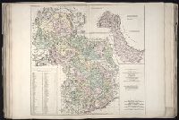
Premiere carte de la Meuse avec les pais, duchez et comtez voisins and Teatre de la guerre en Flandre et Brabant
Description:
Alternate title in upper margin: Premiere carte de la Meuse avec les pais, duchez et comtez voisins., Does not show troop positions or other military locations., Ferro meridian., Imperfect: western sheet (with title cartouche) wanting. Part of eastern map (inset of Arras/Cambrai region) pasted over correction[?]., Includes inset of Arras/Cambrai region and color illustration of battles at upper left and lower right., No. 47 of 69 maps bound together in composite atlas., Originally printed on 4 sheets., Presentee a son altesse Monseigneur le Duc & Comte [sic] de Marlborough, Marquis de Blandford, &c. &c. &c., par son tres-humble et tres-obeissant serviteur, Pierre Mortier, libraire a Amsterdam., Relief shown pictorially., and Scale [ca. 1:250 000].
Publisher:
Apud Petrum Mortier, et se vend a Londres chez David Mortier
Subject (Topic):
Spanish Succession, War of, 1701-1714 --Maps --Early works to 1800