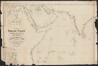
Faden, William, 1749-1836 Palmer, W. (William), 1739-1812 Roberts, Henry, Lieut
Published / Created:
1784
Call Number:
23 1784
Container / Volume:
BRBL_00019
Image Count:
1
Resource Type:
Maps, Atlases & Globes
Alternative Title:
Chart of the northwest coast of America and the northeast coast of Asia, explored in the years 1778 and 1779
Description:
Includes notes., Relief shown pictorially. Depths shown by soundings., and Sheet measures 53 x 80.5 cm.
Publisher:
Wm. Faden, geographer to the King, Charing Cross,
Subject (Geographic):
Bering Strait Region--Discovery and exploration--Maps--Early works to 1800, North America--Discovery and exploration--Maps--Early works to 1800, and Pacific Coast (North America)--Discovery and exploration--Maps--Early works to 1800
Subject (Name):
Cook, James,--1728-1779
Subject (Topic):
Discoveries in geography--Maps--Early works to 1800
First edition, 1784. Improvements in present ed. by Mr. De la Rochette., Not found in Phillips' List of Maps of Am. in LC, nor ST. in Cat. of pr. maps in BM., and Shores tinted by hand, apparently by nationality of discoverer; tracks to the north and return in
North-American pilot for New England, New York, Pensilvania, Maryland, and Virginia.
Description:
A Scale of 5 "English Miles" is given below the title at upper left., Below the scale: The Light-House of Sandy Hook is 40d. 27m. North Latitude., Coordinates not present on map and are approximated., Depths shown by soundings. Relief shown by hachures., First state., Includes note., Issued separately and in the first edition of Sayer & Bennett's North American Pilot for New England, New York, Pensilvania, Maryland, and Virginia. 1777., Sailing chart of the area around New York Harbor and Long Island; centered on Staten Island, York's Bay and Constable Point, extending north to Hells Gate, New York Island, Netwon Inlet, Bushwick Inlet, Wallabout Bay, Crown Point, the Battery and Ship Yards and south to the Shrewsbury River. The map extends East to include Amboy and the Raritan River, noting (Samuel?) Holland's House and east to Jamaica Bay and Plumb Island., and Watermarks.
Publisher:
Printed for Robt. Sayer & John Bennett, sea chart & map-sellers, No. 53, in Fleet Street. Published as the Act directs,
Subject (Geographic):
Atlantic Ocean--Lower Bay, Atlantic Ocean--Upper Bay, New Jersey--Sandy Hook, New York Harbor (N.Y. and N.J.) Maps--Early works to 1800., New York Region--Maps--Early works to 1800., and Sandy Hook (N.J.)
Subject (Name):
Robert Sayer and John Bennett (Firm), printmaker, printseller
Subject (Topic):
Nautical charts, Nautical charts--Hudson River Estuary (N.Y. and N.J.)--Early works to 1800., Nautical charts--Lower Bay (N.Y. and N.J.)--Early works to 1800., and Nautical charts--Upper Bay (N.Y. and N.J.)--Early works to 180