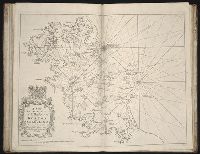
New map of the kingdom of England and Dominion of Wales, New map of the kingdome of England and Wales, and New mapp of the kingdom of England and Dominion of Wales
Description:
Imperfect: upper right of map mutilated, with some loss of text., No. 4 of 69 maps bound together in composite atlas., Relief shown pictorially., Scale [ca. 1:1 110 000]., With an alphabeticall table of all the cities and market towns in England and Wales., and With dedication To the most serene and most sacred Majesty William III ... from William Berry.
Publisher:
Sold by William Berry at the sign of the Globe between Charing Cross and White Hall
Subject (Geographic):
Great Britain --Maps --Early works to 1800
Subject (Topic):
Roads --Great Britain --Maps --Early works to 1800
[Atlas nouveau contenant toutes les parties du monde ou sont exactement marques les empires
Image Count:
1
Resource Type:
Maps, Atlases & Globes
Abstract:
Factitious collection of about 549 maps taken from the atlases of the 17th and the beginning of the 18th century, put together with the title "Atlas" and bound in 6 volumes. These volumes originally bore the imprint: Amstelaedamii apvd Reiniervm & Josvam Ottens. Over these words on the title pages of volumes 1-2 and 4-6 is the name of Henrik de Leth who painted them.
Description:
Verso blank.
Subject (Geographic):
British Isles --Maps --Early works to 1800
Subject (Name):
Leth, Hendrik de, 1703-1766, Reiner et Josua Ottens (Firm), Schenck, Peter, 1661-1715, Schenck, Peter, ca. 1698-1752, Valck, G. (Gerard), 1651 or 2-1726, and Wit, Frederik de
Subject (Topic):
Atlases --Early works to 1800
Collection Created:
[A Amsterdam, chez J. Covens & C. Mortier, ca. 1730-ca. 1800]
Browne, Christopher, fl. 1684-1712 Fer, Nicolas de, 1646-1720, creator
Published / Created:
[1704?]
Call Number:
1973 Folio 10
Image Count:
1
Resource Type:
Maps, Atlases & Globes
Alternative Title:
New map of the theatre of the war in Flanders and on the Rhine and Theatre of the warr in Flanders
Description:
Bar scales given in English miles., Dedicated to Q. Anne by C. Browne., Ferro meridian., Includes inset map the Rhine River Valley., No. 46 of 69 maps bound together in composite atlas., Relief shown pictorially., and Scale [ca. 1:600 000].
Publisher:
Made english and sold by C. Browne at the Globe at the west end of St. Pauls Church
Title and date from item., In upper right margin: 112., and This electronic record is derived from historic data and may not reflect our current information. Review and updating of records is ongoing.
Publisher:
Printed for Bowles & Carver, No. 69 in St. Pauls Church Yard, London. Publishd as the Act directs
Subject (Topic):
Obesity, Indigestion, Dogs, Seesaws, Children, and Eating & drinking
Certaine errors in nauigation / detected and corrected by Edw. Wright ; with many additions that
Image Count:
1
Description:
[ca. 1:5,400,000]., Bound in following p. 110., Linear brown stain at top on verso., Middle panel right of center has small hole., and Several small yellow, brown and black stains can be seen on both the recto and verso.
Subject (Geographic):
Azores
Subject (Topic):
Cosmography--Early works to 1800, Nautical astronomy --Early works to 1800, and Navigation --Early works to 1800
Collection Created:
[London] : Printed by Felix Kingsto[n] at London, 1610
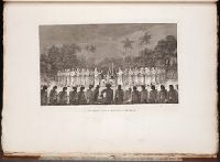
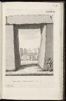
Album containing 122 engravings by Stukeley, many in proof, assembled by the artist himself. Contents include 85 engravings from Itinerarium Curiosum and 23 from Stonehenge, a Temple Restor’d to the British Druids.
Description:
Plate numbered 104.
Subject (Geographic):
Great Britain --Antiquities --Early works to 1800 and Wiltshire (England) --Antiquities
Subject (Topic):
Megalithic monuments --England --Wiltshire and Stonehenge (England)--Early works to 1800